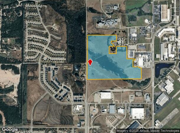
Property Record
201 Ns Nt Pkwy, New Century, KS 66031
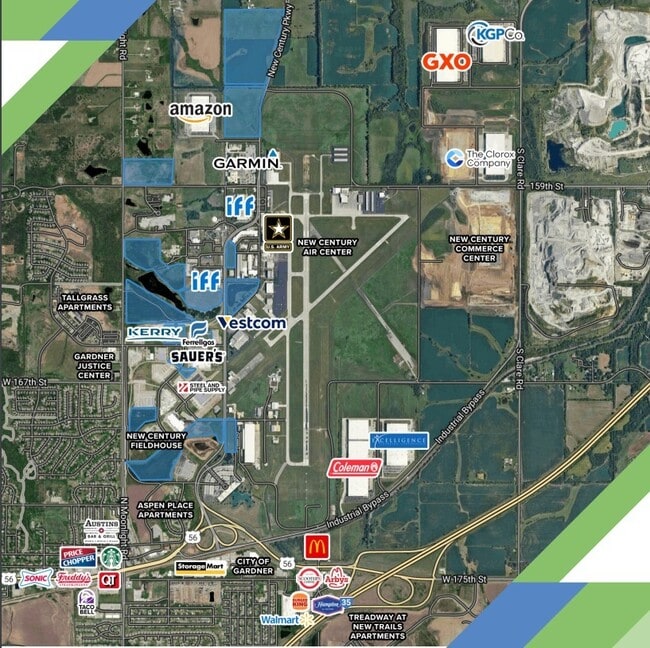
NEARBY LISTINGS FOR SALE OR LEASE
Property Detail
201 Ns Nt Pkwy
2F231418-1003
18-14-23 BG 170 W NE CR NW1/4 S 1140.54 E 170 S 434.95 W 235 S 217.1 W 140.11 SWLY 628.84 S 30 & 7.44 W 25 S 20 SE 35 S 512 E 593.92 S 822 W TO W/L N 3295 TO NW CR NW1/4 E ALG N/L TO POB EX 1.12 AC EX 82.04 AC EX 13.34 AC EX 4.96 AC EX .98 AC EX 1.00
Correctionalfacility
Johnson
X
Kansas
20091C0105G
69.41 AC
0
South Johnson County
2024
Kansas City
053711
Kansas City, MO-KS
2,768 SF
DEMOGRAPHICS near 201 Ns Nt Pkwy
1 Mile
3 Mile
5 Mile
2024 Total Population
2,271
27,554
46,855
2029 Population
2,415
28,956
49,064
Pop Growth 2024-2029
+ 6.34%
+ 5.09%
+ 4.71%
Average Age
36
36
37
2024 Total Households
738
9,299
15,816
HH Growth 2024-2029
+ 6.91%
+ 5.37%
+ 4.98%
Median Household Inc
$98,018
$88,298
$92,272
Avg Household Size
3.10
2.80
2.90
2024 Avg HH Vehicles
2.00
2.00
2.00
Median Home Value
$304,375
$271,713
$284,744
Median Year Built
2002
2001
2000
Nearby Places
- Restaurants
- Banks
- Shops
- Fitness
- Groceries
SALE & LEASE HISTORY
LISTING DATE
SALE/LEASE

Oct 09, 2024
For Sale
Nearby Properties
Address
Land Use
TOTAL SIZE
Lot Size
Zoning
Address
Land Use
TOTAL SIZE
Lot Size
Zoning
287,502 SF
80.54 AC
PEC3
Address
Land Use
TOTAL SIZE
Lot Size
Zoning
345,346 SF
73.42 AC
R-1
Address
Land Use
TOTAL SIZE
Lot Size
Zoning
71,086 SF
22.76 AC
R-3
Address
Land Use
TOTAL SIZE
Lot Size
Zoning
206,145 SF
55.77 AC
Address
Land Use
TOTAL SIZE
Lot Size
Zoning
1,005,940 SF
66.67 AC
L-P
Address
Land Use
TOTAL SIZE
Lot Size
Zoning
746,120 SF
PEC3
Address
Land Use
TOTAL SIZE
Lot Size
Zoning
522,478 SF
45.72 AC
PEC3
Address
Land Use
TOTAL SIZE
Lot Size
Zoning
648,070 SF
33.46 AC
MP-1
Address
Land Use
TOTAL SIZE
Lot Size
Zoning
569,960 SF
26.89 AC
M-2
Address
Land Use
TOTAL SIZE
Lot Size
Zoning
106,819 SF
14.43 AC
PEC3
Address
Land Use
TOTAL SIZE
Lot Size
Zoning
131,178 SF
32.78 AC
R-1
Address
Land Use
TOTAL SIZE
Lot Size
Zoning
19,022 SF
38.73 AC
A
Address
Land Use
TOTAL SIZE
Lot Size
Zoning
565,272 SF
24.79 AC
RUR
Address
Land Use
TOTAL SIZE
Lot Size
Zoning
141,329 SF
20.88 AC
R-1
Address
Land Use
TOTAL SIZE
Lot Size
Zoning
1,107,600 SF
50.97 AC
MP-1
Address
Land Use
TOTAL SIZE
Lot Size
Zoning
73,451 SF
14.39 AC
R-1
Address
Land Use
TOTAL SIZE
Lot Size
Zoning
33,045 SF
15.25 AC
CP-2
Address
Land Use
TOTAL SIZE
Lot Size
Zoning
88,724 SF
127.92 AC
A
Address
Land Use
TOTAL SIZE
Lot Size
Zoning
189,334 SF
12.19 AC
PEC3
Address
Land Use
TOTAL SIZE
Lot Size
Zoning
73,451 SF
12.58 AC
A
Address
Land Use
TOTAL SIZE
Lot Size
Zoning
331,712 SF
PEC3
Address
Land Use
TOTAL SIZE
Lot Size
Zoning
158.84 AC
RUR
Address
Land Use
TOTAL SIZE
Lot Size
Zoning
821,570 SF
44.78 AC
M-2
Address
Land Use
TOTAL SIZE
Lot Size
Zoning
88,250 SF
9.82 AC
PEC3
Address
Land Use
TOTAL SIZE
Lot Size
Zoning
55,482 SF
72.69 AC
PEC3
Address
Land Use
TOTAL SIZE
Lot Size
Zoning
10,956 SF
90 AC
PEC3
Address
Land Use
TOTAL SIZE
Lot Size
Zoning
79,038 SF
15.98 AC
PEC3
Address
Land Use
TOTAL SIZE
Lot Size
Zoning
53,491 SF
14.74 AC
A
The World's #1 Commercial Real Estate Marketplace
Connect with us
© 2025 CoStar Group
The information above has been obtained from sources believed reliable. While we do not doubt its accuracy we have not verified it and make no guarantee, warranty or representation about it. It is your responsibility to independently confirm its accuracy and completeness. Any projections, opinions, assumptions, or estimates used are for example only and do not represent the current or future performance of the property. The value of this transaction to you depends on tax and other factors which should be evaluated by your tax, financial, and legal advisors. You and your advisors should conduct a careful, independent investigation of the property to determine to your satisfaction the suitability of the property for your needs.