Property Record
New Monroe Rd, Bastrop, LA 71220

Save to a Folder
{{folder.Name}}
{{folder.ListingIds.length}} Properties
{{folder.ListingIds.length}} Property
Create a New Folder
Property Detail
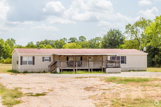
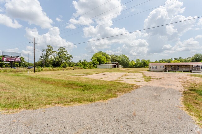
New Monroe Rd
Monroe, LA
LOT 3 & N. 189 FT LOT 2 BL 9 CHARLES H. FISHER CENTRAL SUBD. PLAT BK 2, P. 62. BOT OF W. BONNER IN BK 237, P 270. ..2 ALSO, S
10013300
MOREHOUSE
Officebuilding
Louisiana
A Areas with a 1% annual chance of flooding and a 26% chance of flooding over the life of a 30-year mortgage.
903
2025
2 AC
2025
Louisiana North Area
950500
Other Market Areas
2,550 SF
NEARBY LISTINGS FOR SALE OR LEASE
-
-
View all Bastrop listings for sale on LoopNet.com
DEMOGRAPHICS near New Monroe Rd
1 mile
3 mile
5 mile
2025 Total Population
764
7,796
14,400
2030 Population
728
7,525
13,743
Pop Growth 2025-2030
(4.71%)
(3.48%)
(4.56%)
Average Age
44
40
41
2025 Total Households
322
3,072
5,704
HH Growth 2025-2030
(4.97%)
(3.55%)
(4.73%)
Median Household Inc
$32,635
$31,070
$33,895
Avg Household Size
2.40
2.40
2.40
2025 Avg HH Vehicles
2.00
1.00
2.00
Median Home Value
$91,352
$93,256
$99,735
Median Year Built
1971
1974
1973
Nearby Places
Map Layers
Map Styles
 Street
 Aerial
Layers
 Traffic
 Biking
Places
Listings with unknown addresses are not visible on the map
- Restaurants
- Banks
- Shops
- Fitness
- Groceries
PUBLIC TRANSPORTATION
AIRPORT
Monroe Regional
Drive
Walk
Distance
Monroe Regional
30 min
23.3 mi
Freight Ports
Port of Shreveport
Drive
Walk
Distance
Port of Shreveport
155 min
133.8 mi
SALE & LEASE HISTORY
LISTING DATE
SALE/LEASE

Sep 24, 2016
For Sale
Oct 20, 2016
For Sale
Apr 24, 2017
For Sale
Nearby Properties
Address
Land Use
TOTAL SIZE
Lot Size
Zoning
Address
Land Use
TOTAL SIZE
Lot Size
Zoning
61,904 SF
4.51 AC
Address
Land Use
TOTAL SIZE
Lot Size
Zoning
0.61 AC
Address
Land Use
TOTAL SIZE
Lot Size
Zoning
Address
Land Use
TOTAL SIZE
Lot Size
Zoning
153,814 SF
6.17 AC
Address
Land Use
TOTAL SIZE
Lot Size
Zoning
100,393 SF
21.56 AC
Address
Land Use
TOTAL SIZE
Lot Size
Zoning
0.11 AC
Address
Land Use
TOTAL SIZE
Lot Size
Zoning
40,915 SF
25 AC
Address
Land Use
TOTAL SIZE
Lot Size
Zoning
Address
Land Use
TOTAL SIZE
Lot Size
Zoning
Address
Land Use
TOTAL SIZE
Lot Size
Zoning
29.02 AC
Address
Land Use
TOTAL SIZE
Lot Size
Zoning
10,322 SF
12.69 AC
Address
Land Use
TOTAL SIZE
Lot Size
Zoning
Address
Land Use
TOTAL SIZE
Lot Size
Zoning
58,378 SF
0.25 AC
Address
Land Use
TOTAL SIZE
Lot Size
Zoning
46,606 SF
9 AC
Address
Land Use
TOTAL SIZE
Lot Size
Zoning
57,725 SF
6 AC
Address
Land Use
TOTAL SIZE
Lot Size
Zoning
49,414 SF
11 AC
Address
Land Use
TOTAL SIZE
Lot Size
Zoning
29,809 SF
83 AC
Address
Land Use
TOTAL SIZE
Lot Size
Zoning
46,441 SF
2.61 AC
Address
Land Use
TOTAL SIZE
Lot Size
Zoning
33,176 SF
0.45 AC
Address
Land Use
TOTAL SIZE
Lot Size
Zoning
4.02 AC
Address
Land Use
TOTAL SIZE
Lot Size
Zoning
55,046 SF
9 AC
Address
Land Use
TOTAL SIZE
Lot Size
Zoning
81,559 SF
2.04 AC
Address
Land Use
TOTAL SIZE
Lot Size
Zoning
50,952 SF
12.14 AC
Address
Land Use
TOTAL SIZE
Lot Size
Zoning
8,720 SF
2.12 AC
Address
Land Use
TOTAL SIZE
Lot Size
Zoning
72,739 SF
7.65 AC
Address
Land Use
TOTAL SIZE
Lot Size
Zoning
19,499 SF
7.66 AC
Address
Land Use
TOTAL SIZE
Lot Size
Zoning
1.15 AC
Address
Land Use
TOTAL SIZE
Lot Size
Zoning
55,484 SF
13 AC
Address
Land Use
TOTAL SIZE
Lot Size
Zoning
30,092 SF
2.04 AC
Address
Land Use
TOTAL SIZE
Lot Size
Zoning
20,175 SF
3.23 AC
The World's #1 Commercial Real Estate Marketplace
Connect with us
© 2026 CoStar Group
The information above has been obtained from sources believed reliable. While we do not doubt its accuracy we have not verified it and make no guarantee, warranty or representation about it. It is your responsibility to independently confirm its accuracy and completeness. Any projections, opinions, assumptions, or estimates used are for example only and do not represent the current or future performance of the property. The value of this transaction to you depends on tax and other factors which should be evaluated by your tax, financial, and legal advisors. You and your advisors should conduct a careful, independent investigation of the property to determine to your satisfaction the suitability of the property for your needs.