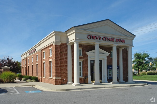
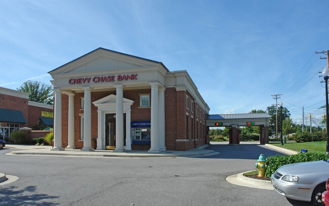
Property Record
Newtowne Dr, Annapolis, MD 21401


Property Detail
Newtowne Dr
06-000-90213794
LAND UNIT B NEWTOWNE DR VILLAGE GREENS LT 2R LAN
Storebuilding
ANNE ARUNDEL
R3
Maryland
AE The base floodplain where base flood elevations are provided. AE Zones are now used on new format FIRMs instead of A1-A30 Zones.
2r
2024
2.87 AC
2025
Annapolis
706600
Baltimore
34,355 SF
Baltimore-Columbia-Towson, MD
NEARBY LISTINGS FOR SALE OR LEASE
DEMOGRAPHICS near Newtowne Dr
1 mile
3 mile
5 mile
2025 Total Population
15,069
70,023
113,302
2030 Population
15,342
71,573
115,602
Pop Growth 2025-2030
+ 1.81%
+ 2.21%
+ 2.03%
Average Age
38
42
43
2025 Total Households
5,532
29,613
46,036
HH Growth 2025-2030
+ 1.95%
+ 2.26%
+ 2.03%
Median Household Inc
$103,781
$112,543
$120,900
Avg Household Size
2.60
2.30
2.40
2025 Avg HH Vehicles
2.00
2.00
2.00
Median Home Value
$451,687
$572,158
$620,252
Median Year Built
1978
1980
1981
Nearby Places
Map Layers
Map Styles
 Street
 Aerial
Layers
 Traffic
 Biking
Places
Listings with unknown addresses are not visible on the map
- Restaurants
- Banks
- Shops
- Fitness
- Groceries
PUBLIC TRANSPORTATION
AIRPORT
Baltimore/Washington International Thurgood Marshall
Drive
Walk
Distance
Baltimore/Washington International Thurgood Marshall
33 min
23.1 mi
Ronald Reagan Washington Ntl
Drive
Walk
Distance
Ronald Reagan Washington Ntl
48 min
34.8 mi
Freight Ports
Port of Baltimore
Drive
Walk
Distance
Port of Baltimore
40 min
28.7 mi
SALE & LEASE HISTORY
LISTING DATE
SALE/LEASE

Mar 24, 2021
For Lease
Dec 07, 2017
For Lease
Nearby Properties
Address
Land Use
TOTAL SIZE
Lot Size
Zoning
Address
Land Use
TOTAL SIZE
Lot Size
Zoning
2,568,175 SF
55.32 AC
TC
Address
Land Use
TOTAL SIZE
Lot Size
Zoning
717,491 SF
26.28 AC
C2
Address
Land Use
TOTAL SIZE
Lot Size
Zoning
6,400 SF
31.17 AC
C1
Address
Land Use
TOTAL SIZE
Lot Size
Zoning
31.16 AC
R4
Address
Land Use
TOTAL SIZE
Lot Size
Zoning
406,976 SF
18.98 AC
R2
Address
Land Use
TOTAL SIZE
Lot Size
Zoning
58.99 AC
R2
Address
Land Use
TOTAL SIZE
Lot Size
Zoning
296,790 SF
27.74 AC
TC
Address
Land Use
TOTAL SIZE
Lot Size
Zoning
313,440 SF
23.43 AC
TC
Address
Land Use
TOTAL SIZE
Lot Size
Zoning
250,163 SF
2.19 AC
P
Address
Land Use
TOTAL SIZE
Lot Size
Zoning
441,482 SF
3.85 AC
W1
Address
Land Use
TOTAL SIZE
Lot Size
Zoning
577,560 SF
3.71 AC
C2
Address
Land Use
TOTAL SIZE
Lot Size
Zoning
346,335 SF
16.42 AC
R22
Address
Land Use
TOTAL SIZE
Lot Size
Zoning
419,712 SF
9.48 AC
R2
Address
Land Use
TOTAL SIZE
Lot Size
Zoning
389,081 SF
4.79 AC
TC
Address
Land Use
TOTAL SIZE
Lot Size
Zoning
591,962 SF
6.43 AC
BCE
Address
Land Use
TOTAL SIZE
Lot Size
Zoning
271,003 SF
1 AC
TC
Address
Land Use
TOTAL SIZE
Lot Size
Zoning
365,268 SF
4.85 AC
W1
Address
Land Use
TOTAL SIZE
Lot Size
Zoning
198,795 SF
36 AC
R2
Address
Land Use
TOTAL SIZE
Lot Size
Zoning
97,888 SF
59.42 AC
C2
Address
Land Use
TOTAL SIZE
Lot Size
Zoning
341,468 SF
1.82 AC
TC
Address
Land Use
TOTAL SIZE
Lot Size
Zoning
435,081 SF
2.62 AC
TC
Address
Land Use
TOTAL SIZE
Lot Size
Zoning
315,260 SF
22.82 AC
C2
Address
Land Use
TOTAL SIZE
Lot Size
Zoning
248,820 SF
24.92 AC
R2
Address
Land Use
TOTAL SIZE
Lot Size
Zoning
309,756 SF
0.01 AC
R-22
Address
Land Use
TOTAL SIZE
Lot Size
Zoning
146,329 SF
1.26 AC
WMC
Address
Land Use
TOTAL SIZE
Lot Size
Zoning
272,275 SF
3.11 AC
P
Address
Land Use
TOTAL SIZE
Lot Size
Zoning
285,174 SF
24 AC
R2
Address
Land Use
TOTAL SIZE
Lot Size
Zoning
194,155 SF
6.69 AC
R1
Address
Land Use
TOTAL SIZE
Lot Size
Zoning
254,969 SF
13.73 AC
W1A
Address
Land Use
TOTAL SIZE
Lot Size
Zoning
8.78 AC
R3
The World's #1 Commercial Real Estate Marketplace
Connect with us
© 2026 CoStar Group
The information above has been obtained from sources believed reliable. While we do not doubt its accuracy we have not verified it and make no guarantee, warranty or representation about it. It is your responsibility to independently confirm its accuracy and completeness. Any projections, opinions, assumptions, or estimates used are for example only and do not represent the current or future performance of the property. The value of this transaction to you depends on tax and other factors which should be evaluated by your tax, financial, and legal advisors. You and your advisors should conduct a careful, independent investigation of the property to determine to your satisfaction the suitability of the property for your needs.