Property Record
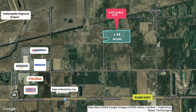
N 300 W, Mccordsville, IN 46055
This Property Is For Sale
NEARBY LISTINGS FOR SALE OR LEASE
Property Detail
N 300 W
30-06-15-200-009.000-006
NW 15-16-6 40.5AC
Agriculturalland
Hancock
X
Indiana
18059C0128D
40.50 AC
2024
Hancock County
2024
Indianapolis
410201
Indianapolis-Carmel-Anderson, IN
DEMOGRAPHICS near N 300 W
1 Mile
3 Mile
5 Mile
2024 Total Population
398
6,061
30,939
2029 Population
436
6,649
34,199
Pop Growth 2024-2029
+ 9.55%
+ 9.70%
+ 10.54%
Average Age
45
43
41
2024 Total Households
158
2,429
12,598
HH Growth 2024-2029
+ 9.49%
+ 10.09%
+ 10.90%
Median Household Inc
$78,846
$74,336
$71,695
Avg Household Size
2.40
2.40
2.40
2024 Avg HH Vehicles
3.00
2.00
2.00
Median Home Value
$199,999
$177,137
$174,445
Median Year Built
1983
1982
1989
Nearby Places
Map Layers
Map Styles
 Street
 Aerial
- Restaurants
- Banks
- Shops
- Fitness
- Groceries
PUBLIC TRANSPORTATION
AIRPORT
Indianapolis International
DRIVE
WALK
Distance
Indianapolis International
59 min
33.6 mi
Freight Ports
Port of Toledo
DRIVE
WALK
Distance
Port of Toledo
263 min
211.9 mi
Nearby Properties
Address
Land Use
TOTAL SIZE
Lot Size
Zoning
Address
Land Use
TOTAL SIZE
Lot Size
Zoning
659,178 SF
84.62 AC
Address
Land Use
TOTAL SIZE
Lot Size
Zoning
13.89 AC
Address
Land Use
TOTAL SIZE
Lot Size
Zoning
41.23 AC
Address
Land Use
TOTAL SIZE
Lot Size
Zoning
54.63 AC
Address
Land Use
TOTAL SIZE
Lot Size
Zoning
416,714 SF
47.60 AC
Address
Land Use
TOTAL SIZE
Lot Size
Zoning
499,913 SF
38.88 AC
Address
Land Use
TOTAL SIZE
Lot Size
Zoning
19.52 AC
Address
Land Use
TOTAL SIZE
Lot Size
Zoning
439,040 SF
31.70 AC
Address
Land Use
TOTAL SIZE
Lot Size
Zoning
423,000 SF
30.62 AC
Address
Land Use
TOTAL SIZE
Lot Size
Zoning
250,000 SF
20.86 AC
Address
Land Use
TOTAL SIZE
Lot Size
Zoning
216,427 SF
19.62 AC
Address
Land Use
TOTAL SIZE
Lot Size
Zoning
243,574 SF
19.92 AC
Address
Land Use
TOTAL SIZE
Lot Size
Zoning
18.91 AC
Address
Land Use
TOTAL SIZE
Lot Size
Zoning
38.09 AC
Address
Land Use
TOTAL SIZE
Lot Size
Zoning
32.32 AC
Address
Land Use
TOTAL SIZE
Lot Size
Zoning
37,826 SF
15.08 AC
Address
Land Use
TOTAL SIZE
Lot Size
Zoning
11.11 AC
Address
Land Use
TOTAL SIZE
Lot Size
Zoning
19.74 AC
Address
Land Use
TOTAL SIZE
Lot Size
Zoning
2,464 SF
22.19 AC
Address
Land Use
TOTAL SIZE
Lot Size
Zoning
20.47 AC
Address
Land Use
TOTAL SIZE
Lot Size
Zoning
17.73 AC
Address
Land Use
TOTAL SIZE
Lot Size
Zoning
20.03 AC
Address
Land Use
TOTAL SIZE
Lot Size
Zoning
2,630 SF
22.52 AC
Address
Land Use
TOTAL SIZE
Lot Size
Zoning
210.59 AC
Address
Land Use
TOTAL SIZE
Lot Size
Zoning
37.52 AC
Address
Land Use
TOTAL SIZE
Lot Size
Zoning
22.78 AC
Address
Land Use
TOTAL SIZE
Lot Size
Zoning
142.95 AC
Address
Land Use
TOTAL SIZE
Lot Size
Zoning
8,304 SF
0.95 AC
Address
Land Use
TOTAL SIZE
Lot Size
Zoning
145.94 AC
Address
Land Use
TOTAL SIZE
Lot Size
Zoning
111.52 AC
The World's #1 Commercial Real Estate Marketplace
Connect with us
© 2026 CoStar Group
The information above has been obtained from sources believed reliable. While we do not doubt its accuracy we have not verified it and make no guarantee, warranty or representation about it. It is your responsibility to independently confirm its accuracy and completeness. Any projections, opinions, assumptions, or estimates used are for example only and do not represent the current or future performance of the property. The value of this transaction to you depends on tax and other factors which should be evaluated by your tax, financial, and legal advisors. You and your advisors should conduct a careful, independent investigation of the property to determine to your satisfaction the suitability of the property for your needs.