Property Record
15 S State St, Freeburg, IL 62243
This Property Is For Sale
NEARBY LISTINGS FOR SALE OR LEASE
-
-
View all Freeburg listings for sale on LoopNet.com
Property Detail
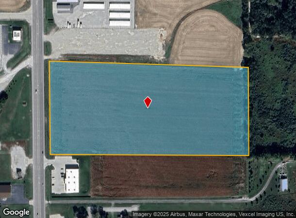
15 S State St
St. Louis
Freeburg Twp
St. Louis, MO-IL
FREEBURG TWP SEC 18& 19 LOT/SEC-18-SUBL/TWP-1S-BLK/RG-7W S 547 FT NW SE DOC A01679946 EXC PT FOR RD 05-ED-20 A02464643
14-18.0-400-042
St. Clair
Agriculturalland
Illinois
2024
16.59 AC
2024
Illinois
503906
DEMOGRAPHICS near 15 S State St
1 Mile
3 Mile
5 Mile
2024 Total Population
1,145
5,727
14,141
2029 Population
1,105
5,511
13,604
Pop Growth 2024-2029
(3.49%)
(3.77%)
(3.80%)
Average Age
43
43
41
2024 Total Households
473
2,217
5,359
HH Growth 2024-2029
(3.59%)
(3.74%)
(3.83%)
Median Household Inc
$96,283
$94,955
$93,193
Avg Household Size
2.40
2.50
2.60
2024 Avg HH Vehicles
2.00
2.00
2.00
Median Home Value
$235,764
$251,557
$223,343
Median Year Built
1987
1987
1988
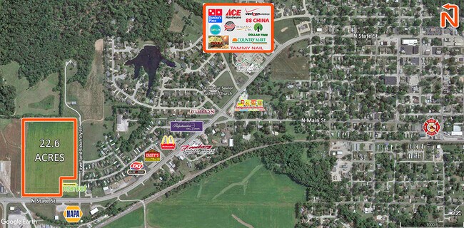
Nearby Places
- Restaurants
- Banks
- Shops
- Fitness
- Groceries
PUBLIC TRANSPORTATION
COMMUTER RAIL
College (Lambert Airport Shiloh-Scott - St. Louis MetroLink (MetroLink))
DRIVE
WALK
Distance
College (Lambert Airport Shiloh-Scott - St. Louis MetroLink (MetroLink))
12 min
7.0 mi
Belleville (Lambert Airport Shiloh-Scott - St. Louis MetroLink (MetroLink))
DRIVE
WALK
Distance
Belleville (Lambert Airport Shiloh-Scott - St. Louis MetroLink (MetroLink))
12 min
8.5 mi
AIRPORT
Scott AFB/Midamerica St Louis
DRIVE
WALK
Distance
Scott AFB/Midamerica St Louis
26 min
14.1 mi
Freight Ports
Port Milwaukee
DRIVE
WALK
Distance
Port Milwaukee
430 min
375.6 mi
Nearby Properties
Address
Land Use
TOTAL SIZE
Lot Size
Zoning
Address
Land Use
TOTAL SIZE
Lot Size
Zoning
9,600 SF
8.59 AC
Address
Land Use
TOTAL SIZE
Lot Size
Zoning
3.90 AC
Address
Land Use
TOTAL SIZE
Lot Size
Zoning
19,576 SF
22.78 AC
Address
Land Use
TOTAL SIZE
Lot Size
Zoning
29,788 SF
6.45 AC
Address
Land Use
TOTAL SIZE
Lot Size
Zoning
217,808 SF
19.45 AC
Address
Land Use
TOTAL SIZE
Lot Size
Zoning
15,000 SF
11.38 AC
Address
Land Use
TOTAL SIZE
Lot Size
Zoning
5,880 SF
28.39 AC
Address
Land Use
TOTAL SIZE
Lot Size
Zoning
19,120 SF
3.45 AC
Address
Land Use
TOTAL SIZE
Lot Size
Zoning
Address
Land Use
TOTAL SIZE
Lot Size
Zoning
7,814 SF
0.83 AC
Address
Land Use
TOTAL SIZE
Lot Size
Zoning
1,209.04 AC
Address
Land Use
TOTAL SIZE
Lot Size
Zoning
9,191 SF
1.21 AC
Address
Land Use
TOTAL SIZE
Lot Size
Zoning
1.63 AC
Address
Land Use
TOTAL SIZE
Lot Size
Zoning
3,000 SF
6.20 AC
Address
Land Use
TOTAL SIZE
Lot Size
Zoning
3,250 SF
0.86 AC
Address
Land Use
TOTAL SIZE
Lot Size
Zoning
13.62 AC
Address
Land Use
TOTAL SIZE
Lot Size
Zoning
3,824 SF
1.64 AC
Address
Land Use
TOTAL SIZE
Lot Size
Zoning
2,961 SF
9.92 AC
Address
Land Use
TOTAL SIZE
Lot Size
Zoning
4,772 SF
1.97 AC
Address
Land Use
TOTAL SIZE
Lot Size
Zoning
8,339 SF
1.70 AC
Address
Land Use
TOTAL SIZE
Lot Size
Zoning
6,666 SF
1.22 AC
Address
Land Use
TOTAL SIZE
Lot Size
Zoning
11,188 SF
5.17 AC
Address
Land Use
TOTAL SIZE
Lot Size
Zoning
4,500 SF
4.94 AC
Address
Land Use
TOTAL SIZE
Lot Size
Zoning
8,000 SF
5.04 AC
Address
Land Use
TOTAL SIZE
Lot Size
Zoning
10,200 SF
1.01 AC
Address
Land Use
TOTAL SIZE
Lot Size
Zoning
7,250 SF
2.60 AC
Address
Land Use
TOTAL SIZE
Lot Size
Zoning
4,096 SF
21.08 AC
Address
Land Use
TOTAL SIZE
Lot Size
Zoning
0.87 AC
Address
Land Use
TOTAL SIZE
Lot Size
Zoning
6,522 SF
1.82 AC
Address
Land Use
TOTAL SIZE
Lot Size
Zoning
3,444 SF
0.56 AC
The World's #1 Commercial Real Estate Marketplace
Connect with us
© 2025 CoStar Group
The information above has been obtained from sources believed reliable. While we do not doubt its accuracy we have not verified it and make no guarantee, warranty or representation about it. It is your responsibility to independently confirm its accuracy and completeness. Any projections, opinions, assumptions, or estimates used are for example only and do not represent the current or future performance of the property. The value of this transaction to you depends on tax and other factors which should be evaluated by your tax, financial, and legal advisors. You and your advisors should conduct a careful, independent investigation of the property to determine to your satisfaction the suitability of the property for your needs.