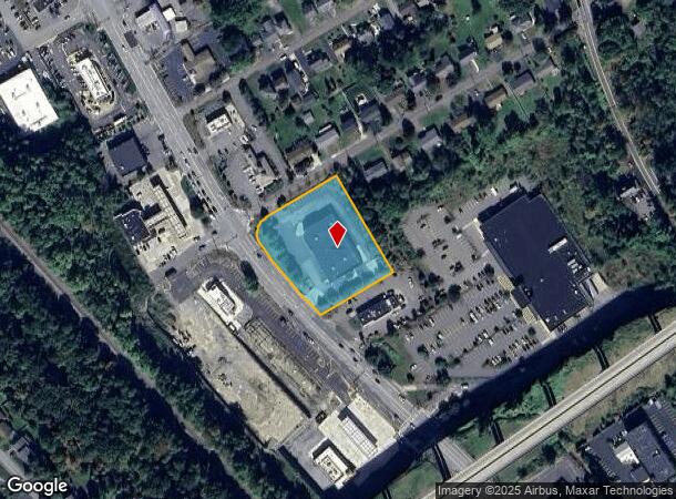
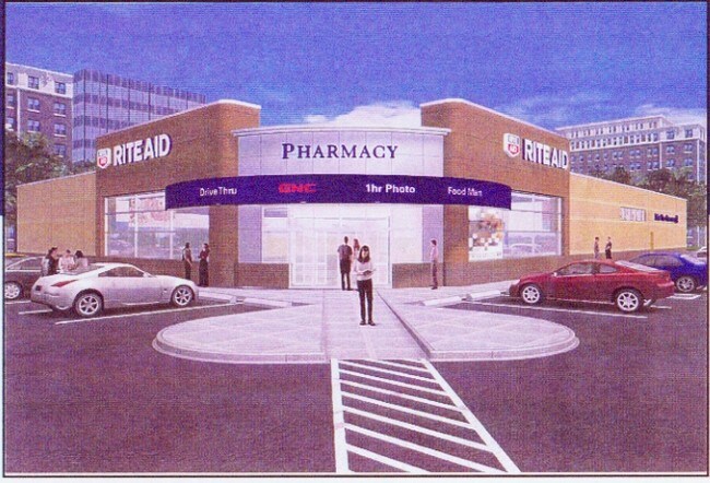
Property Record
Northern Blvd, Clarks Summit, PA 18411

NEARBY LISTINGS FOR SALE OR LEASE
Property Detail
Northern Blvd
Scranton--Wilkes-Barre--Hazelton, PA
1.60A W-01 B-0470 L-0205
10004010003
Lackawanna
Taxexempt
Pennsylvania
AE
205
42069C0202D
1.60 AC
2025
I-81 Corridor
2025
Philadelphia
110500
DEMOGRAPHICS near Northern Blvd
1 Mile
3 Mile
5 Mile
2024 Total Population
6,255
21,023
70,604
2029 Population
6,159
20,669
69,754
Pop Growth 2024-2029
(1.53%)
(1.68%)
(1.20%)
Average Age
43
43
42
2024 Total Households
2,473
8,450
28,845
HH Growth 2024-2029
(1.58%)
(1.66%)
(1.22%)
Median Household Inc
$90,533
$92,088
$66,028
Avg Household Size
2.40
2.40
2.30
2024 Avg HH Vehicles
2.00
2.00
2.00
Median Home Value
$231,592
$242,981
$179,786
Median Year Built
1969
1974
1953
Nearby Places
- Restaurants
- Banks
- Shops
- Fitness
- Groceries
PUBLIC TRANSPORTATION
AIRPORT
Wilkes-Barre/Scranton International
DRIVE
WALK
Distance
Wilkes-Barre/Scranton International
27 min
17.9 mi
Freight Ports
Maher Terminal
DRIVE
WALK
Distance
Maher Terminal
149 min
118.9 mi
Nearby Properties
Address
Land Use
TOTAL SIZE
Lot Size
Zoning
Address
Land Use
TOTAL SIZE
Lot Size
Zoning
Address
Land Use
TOTAL SIZE
Lot Size
Zoning
43.52 AC
Address
Land Use
TOTAL SIZE
Lot Size
Zoning
Address
Land Use
TOTAL SIZE
Lot Size
Zoning
41.75 AC
Address
Land Use
TOTAL SIZE
Lot Size
Zoning
19.70 AC
Address
Land Use
TOTAL SIZE
Lot Size
Zoning
28.89 AC
Address
Land Use
TOTAL SIZE
Lot Size
Zoning
Address
Land Use
TOTAL SIZE
Lot Size
Zoning
7.04 AC
Address
Land Use
TOTAL SIZE
Lot Size
Zoning
Address
Land Use
TOTAL SIZE
Lot Size
Zoning
Address
Land Use
TOTAL SIZE
Lot Size
Zoning
Address
Land Use
TOTAL SIZE
Lot Size
Zoning
20.20 AC
Address
Land Use
TOTAL SIZE
Lot Size
Zoning
Address
Land Use
TOTAL SIZE
Lot Size
Zoning
Address
Land Use
TOTAL SIZE
Lot Size
Zoning
Address
Land Use
TOTAL SIZE
Lot Size
Zoning
Address
Land Use
TOTAL SIZE
Lot Size
Zoning
Address
Land Use
TOTAL SIZE
Lot Size
Zoning
3.99 AC
Address
Land Use
TOTAL SIZE
Lot Size
Zoning
2.55 AC
Address
Land Use
TOTAL SIZE
Lot Size
Zoning
10.57 AC
Address
Land Use
TOTAL SIZE
Lot Size
Zoning
Address
Land Use
TOTAL SIZE
Lot Size
Zoning
Address
Land Use
TOTAL SIZE
Lot Size
Zoning
4.91 AC
Address
Land Use
TOTAL SIZE
Lot Size
Zoning
2.13 AC
Address
Land Use
TOTAL SIZE
Lot Size
Zoning
28.89 AC
Address
Land Use
TOTAL SIZE
Lot Size
Zoning
2.53 AC
Address
Land Use
TOTAL SIZE
Lot Size
Zoning
2.97 AC
Address
Land Use
TOTAL SIZE
Lot Size
Zoning
Address
Land Use
TOTAL SIZE
Lot Size
Zoning
Address
Land Use
TOTAL SIZE
Lot Size
Zoning
204.37 AC
The World's #1 Commercial Real Estate Marketplace
Connect with us
© 2025 CoStar Group
The information above has been obtained from sources believed reliable. While we do not doubt its accuracy we have not verified it and make no guarantee, warranty or representation about it. It is your responsibility to independently confirm its accuracy and completeness. Any projections, opinions, assumptions, or estimates used are for example only and do not represent the current or future performance of the property. The value of this transaction to you depends on tax and other factors which should be evaluated by your tax, financial, and legal advisors. You and your advisors should conduct a careful, independent investigation of the property to determine to your satisfaction the suitability of the property for your needs.