Property Record
Northshore Dr, North Little Rock, AR 72113
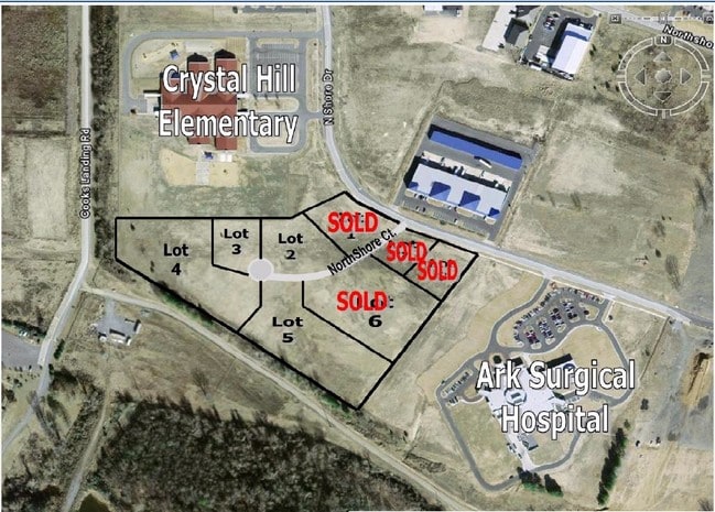


This Property Is For Sale
NEARBY LISTINGS FOR SALE OR LEASE
Property Detail
Northshore Dr
Little Rock-North Little Rock-Conway, AR
Northshore Business Park Sub
43N-008-03-001-01
PT OF LT 1; MPDA BEG AT SE COR LT 1, TH N53 0609W ALG SLN OF SD LT 1 1052.62FT TO SW COR OF SD LT 1; TH N00 0445W ALG WLN OF SD LT 1 199.13FT; TH N89 5550E 637.40FT; TH N50 5039E 248.28 TO W ROW LN OF NORTH SHORE DRIVE; TH ALG W ROW LN ON CURVE TO
Commercialacreage
Pulaski
AE
Arkansas
05119C0336G
1
2025
10.07 AC
2025
North Little Rock
004309
Little Rock/N Little Rock
DEMOGRAPHICS near Northshore Dr
1 Mile
3 Mile
5 Mile
2024 Total Population
72
26,832
117,476
2029 Population
72
26,631
117,107
Pop Growth 2024-2029
0.00%
(0.75%)
(0.31%)
Average Age
40
40
39
2024 Total Households
28
12,687
53,981
HH Growth 2024-2029
0.00%
(0.73%)
(0.34%)
Median Household Inc
$112,500
$68,778
$55,202
Avg Household Size
2.50
2.10
2.10
2024 Avg HH Vehicles
2.00
2.00
2.00
Median Home Value
$320,000
$285,677
$208,216
Median Year Built
1985
1972
1975
Nearby Places
Map Layers
Map Styles
 Street
 Aerial
- Restaurants
- Banks
- Shops
- Fitness
- Groceries
PUBLIC TRANSPORTATION
COMMUTER RAIL
Little Rock Union Station (Texas Eagle - Amtrak)
DRIVE
WALK
Distance
Little Rock Union Station (Texas Eagle - Amtrak)
15 min
10.0 mi
AIRPORT
Bill and Hillary Clinton Ntl/Adams Field
DRIVE
WALK
Distance
Bill and Hillary Clinton Ntl/Adams Field
21 min
14.0 mi
Freight Ports
Port of Shreveport
DRIVE
WALK
Distance
Port of Shreveport
252 min
235.1 mi
Nearby Properties
Address
Land Use
TOTAL SIZE
Lot Size
Zoning
Address
Land Use
TOTAL SIZE
Lot Size
Zoning
89,847 SF
12.77 AC
Address
Land Use
TOTAL SIZE
Lot Size
Zoning
124,774 SF
21.05 AC
Address
Land Use
TOTAL SIZE
Lot Size
Zoning
7,859 SF
175.11 AC
Address
Land Use
TOTAL SIZE
Lot Size
Zoning
1,974 SF
14.30 AC
Address
Land Use
TOTAL SIZE
Lot Size
Zoning
65.57 AC
Address
Land Use
TOTAL SIZE
Lot Size
Zoning
80,720 SF
15.62 AC
Address
Land Use
TOTAL SIZE
Lot Size
Zoning
173,209 SF
26.54 AC
Address
Land Use
TOTAL SIZE
Lot Size
Zoning
318,188 SF
8.86 AC
Address
Land Use
TOTAL SIZE
Lot Size
Zoning
73,197 SF
12.09 AC
Address
Land Use
TOTAL SIZE
Lot Size
Zoning
293,057 SF
20.78 AC
Address
Land Use
TOTAL SIZE
Lot Size
Zoning
48,470 SF
26.37 AC
Address
Land Use
TOTAL SIZE
Lot Size
Zoning
83,352 SF
6.90 AC
Address
Land Use
TOTAL SIZE
Lot Size
Zoning
18,904 SF
12.73 AC
Address
Land Use
TOTAL SIZE
Lot Size
Zoning
155,000 SF
12 AC
Address
Land Use
TOTAL SIZE
Lot Size
Zoning
93,503 SF
34.50 AC
Address
Land Use
TOTAL SIZE
Lot Size
Zoning
42,313 SF
5.17 AC
Address
Land Use
TOTAL SIZE
Lot Size
Zoning
39,082 SF
3.62 AC
Address
Land Use
TOTAL SIZE
Lot Size
Zoning
21,168 SF
8.30 AC
Address
Land Use
TOTAL SIZE
Lot Size
Zoning
74,384 SF
16.97 AC
Address
Land Use
TOTAL SIZE
Lot Size
Zoning
49.39 AC
Address
Land Use
TOTAL SIZE
Lot Size
Zoning
48.52 AC
Address
Land Use
TOTAL SIZE
Lot Size
Zoning
114,030 SF
7.69 AC
Address
Land Use
TOTAL SIZE
Lot Size
Zoning
54,445 SF
157.11 AC
Address
Land Use
TOTAL SIZE
Lot Size
Zoning
177,410 SF
9.19 AC
Address
Land Use
TOTAL SIZE
Lot Size
Zoning
43,918 SF
10.75 AC
Address
Land Use
TOTAL SIZE
Lot Size
Zoning
101,732 SF
2.64 AC
Address
Land Use
TOTAL SIZE
Lot Size
Zoning
60,045 SF
5.12 AC
Address
Land Use
TOTAL SIZE
Lot Size
Zoning
24,951 SF
143.50 AC
Address
Land Use
TOTAL SIZE
Lot Size
Zoning
60,966 SF
21.82 AC
Address
Land Use
TOTAL SIZE
Lot Size
Zoning
1,353 SF
3.76 AC
The World's #1 Commercial Real Estate Marketplace
Connect with us
© 2026 CoStar Group
The information above has been obtained from sources believed reliable. While we do not doubt its accuracy we have not verified it and make no guarantee, warranty or representation about it. It is your responsibility to independently confirm its accuracy and completeness. Any projections, opinions, assumptions, or estimates used are for example only and do not represent the current or future performance of the property. The value of this transaction to you depends on tax and other factors which should be evaluated by your tax, financial, and legal advisors. You and your advisors should conduct a careful, independent investigation of the property to determine to your satisfaction the suitability of the property for your needs.