Property Record
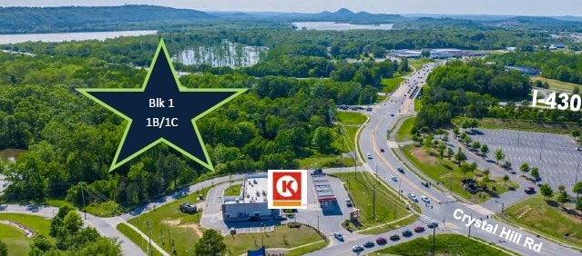
Young Rd, North Little Rock, AR 72118
This Property Is For Sale
NEARBY LISTINGS FOR SALE OR LEASE
Property Detail
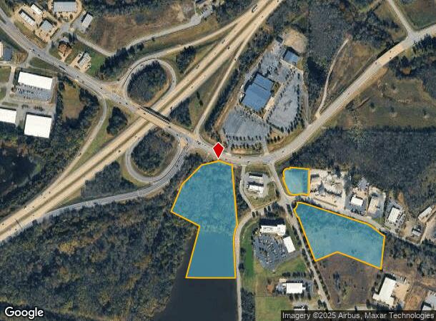
Young Rd
Little Rock-North Little Rock-Conway, AR
Northshore Bus Park
43N-013-00-016-00
PT S1/2 NW MPDA COM NW COR LOT 1A BLOCK 1 TH N60*3702W 123.03 FT TO POB TH S71*2940W 134.31 FT S27*2159W 11.78 FT S77*3336W 146.21 FT S45*3730W 251.56 FT S21*5531W 260.08 FT S62*3948E 288.27 FT S14*5804W 479.25 FT S89*2
Commercialacreage
Pulaski
AE
Arkansas
05119C0336G
1a
2025
11.07 AC
2025
North Little Rock
004302
Little Rock/N Little Rock
DEMOGRAPHICS near Young Rd
1 Mile
3 Mile
5 Mile
2024 Total Population
230
24,431
106,469
2029 Population
230
24,245
105,783
Pop Growth 2024-2029
0.00%
(0.76%)
(0.64%)
Average Age
38
39
40
2024 Total Households
97
11,669
48,946
HH Growth 2024-2029
0.00%
(0.72%)
(0.65%)
Median Household Inc
$63,214
$61,945
$59,301
Avg Household Size
2.30
2.10
2.10
2024 Avg HH Vehicles
2.00
2.00
2.00
Median Home Value
$304,545
$284,256
$228,022
Median Year Built
1993
1978
1976
Nearby Places
Map Layers
Map Styles
 Street
 Aerial
- Restaurants
- Banks
- Shops
- Fitness
- Groceries
PUBLIC TRANSPORTATION
COMMUTER RAIL
Little Rock Union Station (Texas Eagle - Amtrak)
DRIVE
WALK
Distance
Little Rock Union Station (Texas Eagle - Amtrak)
14 min
9.4 mi
AIRPORT
Bill and Hillary Clinton Ntl/Adams Field
DRIVE
WALK
Distance
Bill and Hillary Clinton Ntl/Adams Field
19 min
13.5 mi
Freight Ports
Port of Shreveport
DRIVE
WALK
Distance
Port of Shreveport
251 min
234.5 mi
Nearby Properties
Address
Land Use
TOTAL SIZE
Lot Size
Zoning
Address
Land Use
TOTAL SIZE
Lot Size
Zoning
28,414 SF
80.25 AC
Address
Land Use
TOTAL SIZE
Lot Size
Zoning
89,847 SF
12.77 AC
Address
Land Use
TOTAL SIZE
Lot Size
Zoning
124,774 SF
21.05 AC
Address
Land Use
TOTAL SIZE
Lot Size
Zoning
7,859 SF
175.11 AC
Address
Land Use
TOTAL SIZE
Lot Size
Zoning
35,712 SF
19.92 AC
Address
Land Use
TOTAL SIZE
Lot Size
Zoning
1,974 SF
14.30 AC
Address
Land Use
TOTAL SIZE
Lot Size
Zoning
65.57 AC
Address
Land Use
TOTAL SIZE
Lot Size
Zoning
80,720 SF
15.62 AC
Address
Land Use
TOTAL SIZE
Lot Size
Zoning
173,209 SF
26.54 AC
Address
Land Use
TOTAL SIZE
Lot Size
Zoning
73,197 SF
12.09 AC
Address
Land Use
TOTAL SIZE
Lot Size
Zoning
293,057 SF
20.78 AC
Address
Land Use
TOTAL SIZE
Lot Size
Zoning
83,352 SF
6.90 AC
Address
Land Use
TOTAL SIZE
Lot Size
Zoning
77,478 SF
38.22 AC
Address
Land Use
TOTAL SIZE
Lot Size
Zoning
18,904 SF
12.73 AC
Address
Land Use
TOTAL SIZE
Lot Size
Zoning
155,000 SF
12 AC
Address
Land Use
TOTAL SIZE
Lot Size
Zoning
93,503 SF
34.50 AC
Address
Land Use
TOTAL SIZE
Lot Size
Zoning
42,313 SF
5.17 AC
Address
Land Use
TOTAL SIZE
Lot Size
Zoning
39,082 SF
3.62 AC
Address
Land Use
TOTAL SIZE
Lot Size
Zoning
188,528 SF
24.29 AC
Address
Land Use
TOTAL SIZE
Lot Size
Zoning
66,619 SF
5.89 AC
Address
Land Use
TOTAL SIZE
Lot Size
Zoning
12,346 SF
14.41 AC
Address
Land Use
TOTAL SIZE
Lot Size
Zoning
74,384 SF
16.97 AC
Address
Land Use
TOTAL SIZE
Lot Size
Zoning
49.39 AC
Address
Land Use
TOTAL SIZE
Lot Size
Zoning
48.52 AC
Address
Land Use
TOTAL SIZE
Lot Size
Zoning
177,410 SF
9.19 AC
Address
Land Use
TOTAL SIZE
Lot Size
Zoning
101,732 SF
2.64 AC
Address
Land Use
TOTAL SIZE
Lot Size
Zoning
60,045 SF
5.12 AC
Address
Land Use
TOTAL SIZE
Lot Size
Zoning
24,951 SF
143.50 AC
Address
Land Use
TOTAL SIZE
Lot Size
Zoning
60,966 SF
21.82 AC
Address
Land Use
TOTAL SIZE
Lot Size
Zoning
1,353 SF
3.76 AC
The World's #1 Commercial Real Estate Marketplace
Connect with us
© 2026 CoStar Group
The information above has been obtained from sources believed reliable. While we do not doubt its accuracy we have not verified it and make no guarantee, warranty or representation about it. It is your responsibility to independently confirm its accuracy and completeness. Any projections, opinions, assumptions, or estimates used are for example only and do not represent the current or future performance of the property. The value of this transaction to you depends on tax and other factors which should be evaluated by your tax, financial, and legal advisors. You and your advisors should conduct a careful, independent investigation of the property to determine to your satisfaction the suitability of the property for your needs.