Property Record
Ns # Ns, De Soto, KS 66018
Property Detail
Ns # Ns
AF221225-2005
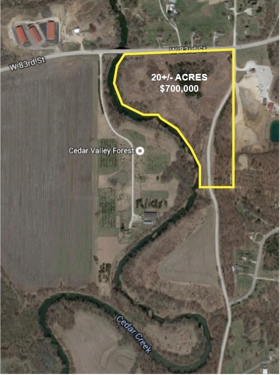
25-12-22 SE1/4 SW1/4 EX S 9 AC EX PT 1/4 1/4 SEC LYG E OF W/L OF TWP RD AS NOW ESTABLISHED & EX .0569 AC 27.5731 ACS M/L DEC 252
Librarymuseum
JOHNSON
R-0
Kansas
AE The base floodplain where base flood elevations are provided. AE Zones are now used on new format FIRMs instead of A1-A30 Zones.
15.44 AC
2024
Northwest Johnson County
2025
Kansas City
052701
Kansas City, MO-KS
NEARBY LISTINGS FOR SALE OR LEASE
-
-
View all De Soto listings for sale on LoopNet.com
DEMOGRAPHICS near Ns # Ns
1 mile
3 mile
5 mile
2025 Total Population
501
10,604
33,912
2030 Population
526
11,145
35,619
Pop Growth 2025-2030
+ 4.99%
+ 5.10%
+ 5.03%
Average Age
43
42
41
2025 Total Households
192
3,836
12,080
HH Growth 2025-2030
+ 5.21%
+ 5.19%
+ 5.17%
Median Household Inc
$130,242
$138,131
$140,200
Avg Household Size
2.60
2.70
2.80
2025 Avg HH Vehicles
2.00
2.00
2.00
Median Home Value
$456,578
$529,900
$520,605
Median Year Built
1991
2003
2003
Nearby Places
Map Layers
Map Styles
 Street
 Aerial
Layers
 Traffic
 Biking
Places
Listings with unknown addresses are not visible on the map
- Restaurants
- Banks
- Shops
- Fitness
- Groceries
PUBLIC TRANSPORTATION
AIRPORT
Kansas City International
Drive
Walk
Distance
Kansas City International
51 min
40.2 mi
Freight Ports
Tulsa Port Of Catoosa
Drive
Walk
Distance
Tulsa Port Of Catoosa
269 min
237.7 mi
SALE & LEASE HISTORY
LISTING DATE
SALE/LEASE

Oct 17, 2017
For Sale
Nearby Properties
Address
Land Use
TOTAL SIZE
Lot Size
Zoning
Address
Land Use
TOTAL SIZE
Lot Size
Zoning
39,668 SF
6.02 AC
Address
Land Use
TOTAL SIZE
Lot Size
Zoning
163,515 SF
70.39 AC
R1
Address
Land Use
TOTAL SIZE
Lot Size
Zoning
74,420 SF
20.04 AC
AG
Address
Land Use
TOTAL SIZE
Lot Size
Zoning
57,788 SF
4.65 AC
O-I
Address
Land Use
TOTAL SIZE
Lot Size
Zoning
436,551 SF
52.90 AC
M-1
Address
Land Use
TOTAL SIZE
Lot Size
Zoning
600 SF
91.25 AC
RUR
Address
Land Use
TOTAL SIZE
Lot Size
Zoning
83.09 AC
AG
Address
Land Use
TOTAL SIZE
Lot Size
Zoning
2,920 SF
3.45 AC
AG
Address
Land Use
TOTAL SIZE
Lot Size
Zoning
2,550 SF
2.52 AC
AG
Address
Land Use
TOTAL SIZE
Lot Size
Zoning
392 SF
37.18 AC
Address
Land Use
TOTAL SIZE
Lot Size
Zoning
9,114 SF
8.66 AC
R1
Address
Land Use
TOTAL SIZE
Lot Size
Zoning
133,668 SF
11.62 AC
M-2
Address
Land Use
TOTAL SIZE
Lot Size
Zoning
1,206 SF
29.82 AC
Address
Land Use
TOTAL SIZE
Lot Size
Zoning
99,750 SF
3.40 AC
M-2
Address
Land Use
TOTAL SIZE
Lot Size
Zoning
29.53 AC
AG
Address
Land Use
TOTAL SIZE
Lot Size
Zoning
7,320 SF
0.64 AC
C-2
Address
Land Use
TOTAL SIZE
Lot Size
Zoning
7,625 SF
4.54 AC
R-0
Address
Land Use
TOTAL SIZE
Lot Size
Zoning
576 SF
14.19 AC
Address
Land Use
TOTAL SIZE
Lot Size
Zoning
12,231 SF
0.82 AC
P-D
Address
Land Use
TOTAL SIZE
Lot Size
Zoning
16,086 SF
2.61 AC
C-2
Address
Land Use
TOTAL SIZE
Lot Size
Zoning
755,060 SF
41.21 AC
Address
Land Use
TOTAL SIZE
Lot Size
Zoning
77,519 SF
15.20 AC
M-1
Address
Land Use
TOTAL SIZE
Lot Size
Zoning
20.40 AC
R1
Address
Land Use
TOTAL SIZE
Lot Size
Zoning
3,870 SF
0.42 AC
C-1
Address
Land Use
TOTAL SIZE
Lot Size
Zoning
7,106 SF
0.71 AC
RUR
Address
Land Use
TOTAL SIZE
Lot Size
Zoning
16.50 AC
AG
Address
Land Use
TOTAL SIZE
Lot Size
Zoning
7,409 SF
0.28 AC
C-1
Address
Land Use
TOTAL SIZE
Lot Size
Zoning
58.33 AC
AG
Address
Land Use
TOTAL SIZE
Lot Size
Zoning
14.14 AC
Address
Land Use
TOTAL SIZE
Lot Size
Zoning
51.50 AC
RP1
The World's #1 Commercial Real Estate Marketplace
Connect with us
© 2026 CoStar Group
The information above has been obtained from sources believed reliable. While we do not doubt its accuracy we have not verified it and make no guarantee, warranty or representation about it. It is your responsibility to independently confirm its accuracy and completeness. Any projections, opinions, assumptions, or estimates used are for example only and do not represent the current or future performance of the property. The value of this transaction to you depends on tax and other factors which should be evaluated by your tax, financial, and legal advisors. You and your advisors should conduct a careful, independent investigation of the property to determine to your satisfaction the suitability of the property for your needs.