Property Record
Ns # Ns, De Soto, KS 66018

Property Detail
Ns # Ns
Kansas City, MO-KS
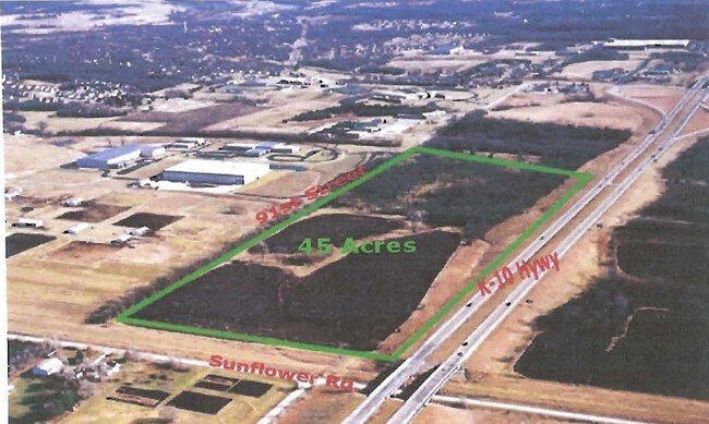
32-12-22 BG NE CR SW1/4 S ALG E/L 1/4 865 TO N RTWY K-10 HWY NW ALG RTWY 1505.20 SW 661.90 & W 358.58 TO PT 145 E OF W/L 1/4 N 787.73 TO N/L 1/4 E ALG N/L 1/4 2510.58 TO POB EX .139 AC IN ST & EX 2.305 AC IN ST 42.244 ACS M/L
AF221232-2001
JOHNSON
Chemical
Kansas
M-1
1
2025
41.84 AC
2025
Northwest Johnson County
052701
Kansas City
NEARBY LISTINGS FOR SALE OR LEASE
DEMOGRAPHICS near Ns # Ns
1 mile
3 mile
5 mile
2025 Total Population
404
6,452
9,907
2030 Population
425
6,790
10,365
Pop Growth 2025-2030
+ 5.20%
+ 5.24%
+ 4.62%
Average Age
40
40
41
2025 Total Households
148
2,400
3,685
HH Growth 2025-2030
+ 5.41%
+ 5.38%
+ 4.75%
Median Household Inc
$87,068
$94,718
$97,432
Avg Household Size
2.70
2.70
2.70
2025 Avg HH Vehicles
2.00
2.00
2.00
Median Home Value
$429,411
$406,707
$431,513
Median Year Built
1991
1989
1989
Nearby Places
Map Layers
Map Styles
 Street
 Aerial
Layers
 Traffic
 Biking
Places
Listings with unknown addresses are not visible on the map
- Restaurants
- Banks
- Shops
- Fitness
- Groceries
PUBLIC TRANSPORTATION
AIRPORT
Kansas City International
Drive
Walk
Distance
Kansas City International
57 min
48.2 mi
Freight Ports
Tulsa Port Of Catoosa
Drive
Walk
Distance
Tulsa Port Of Catoosa
268 min
226.2 mi
SALE & LEASE HISTORY
LISTING DATE
SALE/LEASE

Sep 24, 2016
For Sale
Nearby Properties
Address
Land Use
TOTAL SIZE
Lot Size
Zoning
Address
Land Use
TOTAL SIZE
Lot Size
Zoning
4,833,391 SF
260.48 AC
M-1
Address
Land Use
TOTAL SIZE
Lot Size
Zoning
261,124 SF
28.29 AC
O-I
Address
Land Use
TOTAL SIZE
Lot Size
Zoning
17,561 SF
6.91 AC
M-1
Address
Land Use
TOTAL SIZE
Lot Size
Zoning
186,690 SF
30.21 AC
O-I
Address
Land Use
TOTAL SIZE
Lot Size
Zoning
1,016,186 SF
54.32 AC
RUR
Address
Land Use
TOTAL SIZE
Lot Size
Zoning
86,459 SF
17.20 AC
O-I
Address
Land Use
TOTAL SIZE
Lot Size
Zoning
3,416 SF
3.20 AC
M-1
Address
Land Use
TOTAL SIZE
Lot Size
Zoning
57,788 SF
4.65 AC
O-I
Address
Land Use
TOTAL SIZE
Lot Size
Zoning
436,551 SF
52.90 AC
M-1
Address
Land Use
TOTAL SIZE
Lot Size
Zoning
298,974 SF
146 AC
M-1
Address
Land Use
TOTAL SIZE
Lot Size
Zoning
35,725 SF
9.52 AC
R-0
Address
Land Use
TOTAL SIZE
Lot Size
Zoning
116,622 SF
164.92 AC
M-1
Address
Land Use
TOTAL SIZE
Lot Size
Zoning
2 AC
RUR
Address
Land Use
TOTAL SIZE
Lot Size
Zoning
1,874 SF
46.62 AC
RUR
Address
Land Use
TOTAL SIZE
Lot Size
Zoning
158.57 AC
RUR
Address
Land Use
TOTAL SIZE
Lot Size
Zoning
133,668 SF
11.62 AC
M-2
Address
Land Use
TOTAL SIZE
Lot Size
Zoning
99,750 SF
3.40 AC
M-2
Address
Land Use
TOTAL SIZE
Lot Size
Zoning
18,000 SF
3.31 AC
M-1
Address
Land Use
TOTAL SIZE
Lot Size
Zoning
5,000 SF
20.03 AC
RUR
Address
Land Use
TOTAL SIZE
Lot Size
Zoning
7,320 SF
0.64 AC
C-2
Address
Land Use
TOTAL SIZE
Lot Size
Zoning
7,625 SF
4.54 AC
R-0
Address
Land Use
TOTAL SIZE
Lot Size
Zoning
37,081 SF
5.46 AC
M-1
Address
Land Use
TOTAL SIZE
Lot Size
Zoning
10,620 SF
5.85 AC
R-1
Address
Land Use
TOTAL SIZE
Lot Size
Zoning
12,231 SF
0.82 AC
P-D
Address
Land Use
TOTAL SIZE
Lot Size
Zoning
16,086 SF
2.61 AC
C-2
Address
Land Use
TOTAL SIZE
Lot Size
Zoning
77,519 SF
15.20 AC
M-1
Address
Land Use
TOTAL SIZE
Lot Size
Zoning
19.57 AC
O-I
Address
Land Use
TOTAL SIZE
Lot Size
Zoning
46,024 SF
3.64 AC
M-1
Address
Land Use
TOTAL SIZE
Lot Size
Zoning
3,870 SF
0.42 AC
C-1
The World's #1 Commercial Real Estate Marketplace
Connect with us
© 2026 CoStar Group
The information above has been obtained from sources believed reliable. While we do not doubt its accuracy we have not verified it and make no guarantee, warranty or representation about it. It is your responsibility to independently confirm its accuracy and completeness. Any projections, opinions, assumptions, or estimates used are for example only and do not represent the current or future performance of the property. The value of this transaction to you depends on tax and other factors which should be evaluated by your tax, financial, and legal advisors. You and your advisors should conduct a careful, independent investigation of the property to determine to your satisfaction the suitability of the property for your needs.