Property Record
Ns # Ns, Gardner, KS 66030
Property Detail
Ns # Ns
Kansas City, MO-KS
7-14-23 PT NE1/4 BG 630.99 S NW CR NE1/4 S 2012.17 E 685.37 N 2013.72 W 686.60 TO POB 31.7 ACS M/L
2F231407-3002
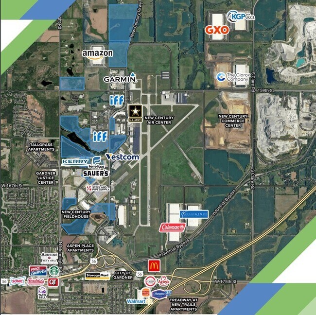
JOHNSON
Aircraft
Kansas
RUR
108.22 AC
B and X Area of moderate flood hazard, usually the area between the limits of the 100-year and 500-year floods.
South Johnson County
2024
Kansas City
2025
NEARBY LISTINGS FOR SALE OR LEASE
DEMOGRAPHICS near Ns # Ns
1 mile
3 mile
5 mile
2025 Total Population
465
17,191
60,646
2030 Population
490
17,951
63,023
Pop Growth 2025-2030
+ 5.38%
+ 4.42%
+ 3.92%
Average Age
39
37
37
2025 Total Households
153
5,612
20,570
HH Growth 2025-2030
+ 5.88%
+ 4.70%
+ 4.13%
Median Household Inc
$173,333
$110,059
$98,441
Avg Household Size
3.00
2.90
2.80
2025 Avg HH Vehicles
3.00
2.00
2.00
Median Home Value
$467,532
$361,258
$339,179
Median Year Built
2007
2001
1999
Nearby Places
Map Layers
Map Styles
 Street
 Aerial
Transit
 Traffic
 Biking
Places
Listings with unknown addresses are not visible on the map
- Restaurants
- Banks
- Shops
- Fitness
- Groceries
SALE & LEASE HISTORY
LISTING DATE
SALE/LEASE

Oct 09, 2024
For Sale
Nearby Properties
Address
Land Use
TOTAL SIZE
Lot Size
Zoning
Address
Land Use
TOTAL SIZE
Lot Size
Zoning
287,502 SF
80.54 AC
PEC3
Address
Land Use
TOTAL SIZE
Lot Size
Zoning
746,120 SF
PEC3
Address
Land Use
TOTAL SIZE
Lot Size
Zoning
648,070 SF
33.46 AC
MP-1
Address
Land Use
TOTAL SIZE
Lot Size
Zoning
522,478 SF
45.72 AC
PEC3
Address
Land Use
TOTAL SIZE
Lot Size
Zoning
569,960 SF
26.86 AC
M-2
Address
Land Use
TOTAL SIZE
Lot Size
Zoning
565,272 SF
24.79 AC
RUR
Address
Land Use
TOTAL SIZE
Lot Size
Zoning
320,835 SF
57.95 AC
M-2
Address
Land Use
TOTAL SIZE
Lot Size
Zoning
106,819 SF
14.43 AC
PEC3
Address
Land Use
TOTAL SIZE
Lot Size
Zoning
188,944 SF
31.48 AC
R-1
Address
Land Use
TOTAL SIZE
Lot Size
Zoning
331,712 SF
PEC3
Address
Land Use
TOTAL SIZE
Lot Size
Zoning
141,329 SF
20.88 AC
R-1
Address
Land Use
TOTAL SIZE
Lot Size
Zoning
1,107,600 SF
50.97 AC
MP-1
Address
Land Use
TOTAL SIZE
Lot Size
Zoning
11,271 SF
4.26 AC
PEC3
Address
Land Use
TOTAL SIZE
Lot Size
Zoning
33,045 SF
15.25 AC
CP-2
Address
Land Use
TOTAL SIZE
Lot Size
Zoning
212,032 SF
9.53 AC
RUR
Address
Land Use
TOTAL SIZE
Lot Size
Zoning
158.84 AC
RUR
Address
Land Use
TOTAL SIZE
Lot Size
Zoning
821,570 SF
44.78 AC
M-2
Address
Land Use
TOTAL SIZE
Lot Size
Zoning
88,250 SF
9.82 AC
PEC3
Address
Land Use
TOTAL SIZE
Lot Size
Zoning
68,645 SF
10.73 AC
MP-2
Address
Land Use
TOTAL SIZE
Lot Size
Zoning
189,334 SF
12.19 AC
PEC3
Address
Land Use
TOTAL SIZE
Lot Size
Zoning
137,532 SF
12.02 AC
M-2
Address
Land Use
TOTAL SIZE
Lot Size
Zoning
33,833 SF
13.36 AC
M-2
Address
Land Use
TOTAL SIZE
Lot Size
Zoning
55,482 SF
72.69 AC
PEC3
Address
Land Use
TOTAL SIZE
Lot Size
Zoning
64,221 SF
8.79 AC
R-1
Address
Land Use
TOTAL SIZE
Lot Size
Zoning
10,956 SF
90 AC
PEC3
Address
Land Use
TOTAL SIZE
Lot Size
Zoning
22,176 SF
62.47 AC
CTY RUR
Address
Land Use
TOTAL SIZE
Lot Size
Zoning
79,038 SF
15.98 AC
PEC3
The World's #1 Commercial Real Estate Marketplace
Connect with us
© 2026 CoStar Group
The information above has been obtained from sources believed reliable. While we do not doubt its accuracy we have not verified it and make no guarantee, warranty or representation about it. It is your responsibility to independently confirm its accuracy and completeness. Any projections, opinions, assumptions, or estimates used are for example only and do not represent the current or future performance of the property. The value of this transaction to you depends on tax and other factors which should be evaluated by your tax, financial, and legal advisors. You and your advisors should conduct a careful, independent investigation of the property to determine to your satisfaction the suitability of the property for your needs.