Property Record
Ns # Ns, Leawood, KS 66224
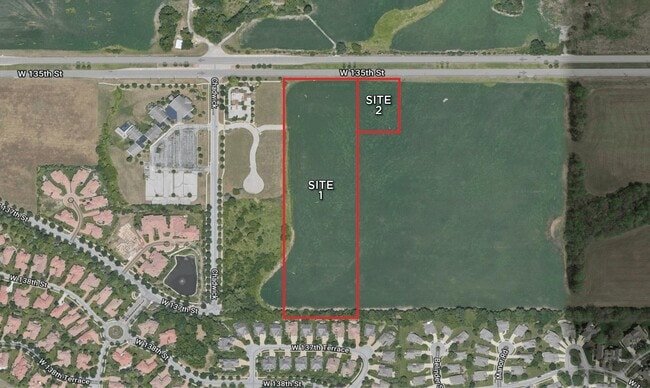

This Property Is For Sale
NEARBY LISTINGS FOR SALE OR LEASE
Property Detail
Ns # Ns
HF251334-3010
34-13-25 E 1/2 W 1/2 NW1/4 NE1/4 EX .811 AC IN ST 9.245 ACS M/L
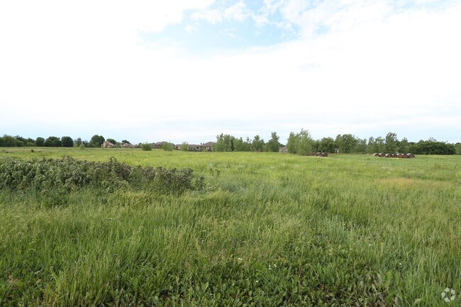
Farms
Johnson
X
Kansas
29095C0388G
8.83 AC
2024
South Johnson County
2024
Kansas City
053409
Kansas City, MO-KS
DEMOGRAPHICS near Ns # Ns
1 Mile
3 Mile
5 Mile
2024 Total Population
6,026
58,582
150,082
2029 Population
6,215
60,684
155,187
Pop Growth 2024-2029
+ 3.14%
+ 3.59%
+ 3.40%
Average Age
44
43
42
2024 Total Households
2,416
24,153
62,155
HH Growth 2024-2029
+ 3.19%
+ 3.78%
+ 3.50%
Median Household Inc
$139,533
$115,720
$99,893
Avg Household Size
2.50
2.40
2.30
2024 Avg HH Vehicles
2.00
2.00
2.00
Median Home Value
$605,431
$465,427
$394,846
Median Year Built
1996
1995
1990
Nearby Places
Map Layers
Map Styles
 Street
 Aerial
- Restaurants
- Banks
- Shops
- Fitness
- Groceries
PUBLIC TRANSPORTATION
AIRPORT
Kansas City International
DRIVE
WALK
Distance
Kansas City International
50 min
39.9 mi
Freight Ports
Tulsa Port Of Catoosa
DRIVE
WALK
Distance
Tulsa Port Of Catoosa
247 min
222.1 mi
Nearby Properties
Address
Land Use
TOTAL SIZE
Lot Size
Zoning
Address
Land Use
TOTAL SIZE
Lot Size
Zoning
1,173,824 SF
63.09 AC
R-1
Address
Land Use
TOTAL SIZE
Lot Size
Zoning
364,818 SF
25.48 AC
R-1
Address
Land Use
TOTAL SIZE
Lot Size
Zoning
384,819 SF
67.59 AC
AG
Address
Land Use
TOTAL SIZE
Lot Size
Zoning
305,147 SF
49.02 AC
R-1
Address
Land Use
TOTAL SIZE
Lot Size
Zoning
335,643 SF
25.13 AC
R-1
Address
Land Use
TOTAL SIZE
Lot Size
Zoning
184,524 SF
33.20 AC
AG
Address
Land Use
TOTAL SIZE
Lot Size
Zoning
325,588 SF
36.63 AC
SD-CR
Address
Land Use
TOTAL SIZE
Lot Size
Zoning
173,314 SF
25.83 AC
R-1
Address
Land Use
TOTAL SIZE
Lot Size
Zoning
79,917 SF
7.86 AC
SD-NCR
Address
Land Use
TOTAL SIZE
Lot Size
Zoning
122,491 SF
19.30 AC
R-1
Address
Land Use
TOTAL SIZE
Lot Size
Zoning
102,411 SF
17.02 AC
AG
Address
Land Use
TOTAL SIZE
Lot Size
Zoning
166,097 SF
37.29 AC
R-1
Address
Land Use
TOTAL SIZE
Lot Size
Zoning
105,110 SF
8.93 AC
AG
Address
Land Use
TOTAL SIZE
Lot Size
Zoning
76,942 SF
15.10 AC
R-1
Address
Land Use
TOTAL SIZE
Lot Size
Zoning
72,184 SF
9.53 AC
AG
Address
Land Use
TOTAL SIZE
Lot Size
Zoning
66,083 SF
14.91 AC
R-1
Address
Land Use
TOTAL SIZE
Lot Size
Zoning
9,508 SF
8.29 AC
RP-1
Address
Land Use
TOTAL SIZE
Lot Size
Zoning
159,274 SF
14.38 AC
SD-CR
Address
Land Use
TOTAL SIZE
Lot Size
Zoning
59,770 SF
8.88 AC
CP-2
Address
Land Use
TOTAL SIZE
Lot Size
Zoning
56,287 SF
7.88 AC
R-1
Address
Land Use
TOTAL SIZE
Lot Size
Zoning
28,633 SF
13.25 AC
R-1
Address
Land Use
TOTAL SIZE
Lot Size
Zoning
68,493 SF
9.92 AC
R-1
Address
Land Use
TOTAL SIZE
Lot Size
Zoning
40,181 SF
1.80 AC
MXD
Address
Land Use
TOTAL SIZE
Lot Size
Zoning
43,021 SF
7.47 AC
SD-O
Address
Land Use
TOTAL SIZE
Lot Size
Zoning
36,012 SF
18.10 AC
AG
Address
Land Use
TOTAL SIZE
Lot Size
Zoning
67,523 SF
11.95 AC
R-1
Address
Land Use
TOTAL SIZE
Lot Size
Zoning
26,022 SF
109.48 AC
IP-2J
Address
Land Use
TOTAL SIZE
Lot Size
Zoning
60,960 SF
4.82 AC
SD-NCR
Address
Land Use
TOTAL SIZE
Lot Size
Zoning
268,536 SF
12.69 AC
CP-O
Address
Land Use
TOTAL SIZE
Lot Size
Zoning
69,026 SF
34.84 AC
RP-3
The World's #1 Commercial Real Estate Marketplace
Connect with us
© 2025 CoStar Group
The information above has been obtained from sources believed reliable. While we do not doubt its accuracy we have not verified it and make no guarantee, warranty or representation about it. It is your responsibility to independently confirm its accuracy and completeness. Any projections, opinions, assumptions, or estimates used are for example only and do not represent the current or future performance of the property. The value of this transaction to you depends on tax and other factors which should be evaluated by your tax, financial, and legal advisors. You and your advisors should conduct a careful, independent investigation of the property to determine to your satisfaction the suitability of the property for your needs.