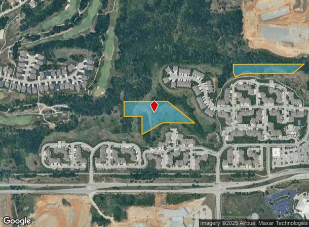
Property Record
Ns # Ns, Lenexa, KS 66219

NEARBY LISTINGS FOR SALE OR LEASE
Property Detail
Ns # Ns
IF241231-4004
31-12-24 S 1/2 SE1/4 EX BG NE CR S 506.5 W 25 NW TO PT ON N/L S 1/2 SE1/4 230 W NE CR E 230 TO POB EX 10.56 AC EX 1.621 AC IN RD & EX .597 AC IN RD & EX 3 TRS PLATTED 1.5357 AC 3.3686 AC & 4.7495 & EX 11.348 AC & EX 39.507 AC & EX .43 AC IN ST & EX .
Commercialnec
Johnson
X
Kansas
20091C0049G
6.13 AC
2024
Northwest Johnson County
2024
Kansas City
052504
Kansas City, MO-KS
DEMOGRAPHICS near Ns # Ns
1 Mile
3 Mile
5 Mile
2024 Total Population
4,888
47,140
173,997
2029 Population
5,148
49,283
181,306
Pop Growth 2024-2029
+ 5.32%
+ 4.55%
+ 4.20%
Average Age
38
41
40
2024 Total Households
2,607
19,561
71,080
HH Growth 2024-2029
+ 5.45%
+ 4.62%
+ 4.26%
Median Household Inc
$77,442
$98,025
$88,955
Avg Household Size
1.90
2.40
2.40
2024 Avg HH Vehicles
2.00
2.00
2.00
Median Home Value
$426,961
$345,246
$303,020
Median Year Built
2003
1994
1988
Nearby Places
Map Layers
Map Styles
 Street
 Aerial
- Restaurants
- Banks
- Shops
- Fitness
- Groceries
PUBLIC TRANSPORTATION
AIRPORT
Kansas City International
DRIVE
WALK
Distance
Kansas City International
42 min
35.0 mi
Freight Ports
Tulsa Port Of Catoosa
DRIVE
WALK
Distance
Tulsa Port Of Catoosa
257 min
228.5 mi
Nearby Properties
Address
Land Use
TOTAL SIZE
Lot Size
Zoning
Address
Land Use
TOTAL SIZE
Lot Size
Zoning
740,953 SF
88.91 AC
RP5
Address
Land Use
TOTAL SIZE
Lot Size
Zoning
208,693 SF
22.30 AC
BP1
Address
Land Use
TOTAL SIZE
Lot Size
Zoning
133,932 SF
3.29 AC
CC
Address
Land Use
TOTAL SIZE
Lot Size
Zoning
635,676 SF
30.59 AC
BP2
Address
Land Use
TOTAL SIZE
Lot Size
Zoning
564,948 SF
27.40 AC
AG
Address
Land Use
TOTAL SIZE
Lot Size
Zoning
606,171 SF
31 AC
BP2
Address
Land Use
TOTAL SIZE
Lot Size
Zoning
144,755 SF
22.19 AC
BP2
Address
Land Use
TOTAL SIZE
Lot Size
Zoning
69,872 SF
1.91 AC
CC
Address
Land Use
TOTAL SIZE
Lot Size
Zoning
404,388 SF
21.55 AC
BP2
Address
Land Use
TOTAL SIZE
Lot Size
Zoning
49,029 SF
15.02 AC
BP1
Address
Land Use
TOTAL SIZE
Lot Size
Zoning
120,492 SF
10 AC
R1
Address
Land Use
TOTAL SIZE
Lot Size
Zoning
222,396 SF
14.76 AC
BP2
Address
Land Use
TOTAL SIZE
Lot Size
Zoning
141,340 SF
19.92 AC
R1
Address
Land Use
TOTAL SIZE
Lot Size
Zoning
347,324 SF
18.16 AC
BP2
Address
Land Use
TOTAL SIZE
Lot Size
Zoning
75,010 SF
24.78 AC
RP2
Address
Land Use
TOTAL SIZE
Lot Size
Zoning
249,780 SF
15.75 AC
BP2
Address
Land Use
TOTAL SIZE
Lot Size
Zoning
72,994 SF
7.99 AC
RP3
Address
Land Use
TOTAL SIZE
Lot Size
Zoning
267,668 SF
17.36 AC
BP2
Address
Land Use
TOTAL SIZE
Lot Size
Zoning
49,282 SF
11.89 AC
RP1
Address
Land Use
TOTAL SIZE
Lot Size
Zoning
255,160 SF
15 AC
BP2
Address
Land Use
TOTAL SIZE
Lot Size
Zoning
204,922 SF
14.73 AC
BP2
Address
Land Use
TOTAL SIZE
Lot Size
Zoning
36,903 SF
0.55 AC
CC
Address
Land Use
TOTAL SIZE
Lot Size
Zoning
42,261 SF
9.58 AC
R1
Address
Land Use
TOTAL SIZE
Lot Size
Zoning
143,055 SF
8.11 AC
BP1
Address
Land Use
TOTAL SIZE
Lot Size
Zoning
56,347 SF
0.76 AC
CC
Address
Land Use
TOTAL SIZE
Lot Size
Zoning
73,003 SF
15.62 AC
R1
Address
Land Use
TOTAL SIZE
Lot Size
Zoning
140,608 SF
11.33 AC
BP2
Address
Land Use
TOTAL SIZE
Lot Size
Zoning
32,272 SF
3.61 AC
BP1
Address
Land Use
TOTAL SIZE
Lot Size
Zoning
70,672 SF
8.85 AC
BP2
Address
Land Use
TOTAL SIZE
Lot Size
Zoning
186,546 SF
20.42 AC
CP2
The World's #1 Commercial Real Estate Marketplace
Connect with us
© 2026 CoStar Group
The information above has been obtained from sources believed reliable. While we do not doubt its accuracy we have not verified it and make no guarantee, warranty or representation about it. It is your responsibility to independently confirm its accuracy and completeness. Any projections, opinions, assumptions, or estimates used are for example only and do not represent the current or future performance of the property. The value of this transaction to you depends on tax and other factors which should be evaluated by your tax, financial, and legal advisors. You and your advisors should conduct a careful, independent investigation of the property to determine to your satisfaction the suitability of the property for your needs.