Property Record
Ns # Ns, Lenexa, KS
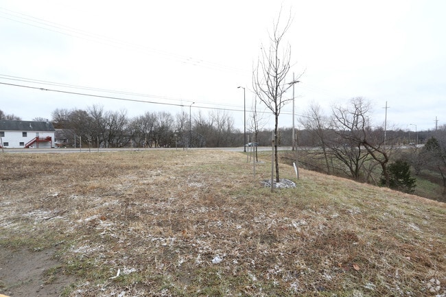
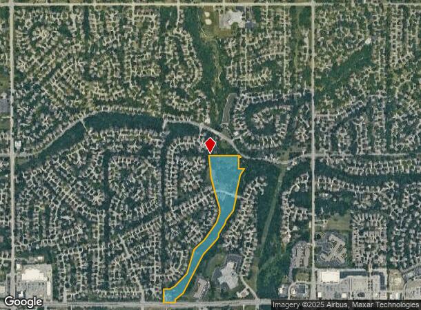

Property Detail
Ns # Ns
Kansas City, MO-KS
Oak Valley
IF241228-4013
28-12-24 BG 45 N SW CR SE1/4 TO N RTWY 87TH ST N 241.61 TOSW CR LT 1 OAK VALLEY 1ST PLATNE 113.52 TO SE CR LT 1 NE TOSE CR LT 2 NE 306.08 TO SE CRLT 6 NE TO NE CR LT 11 NE 231.64 TO S CR LT 15 NE 378.10 TO S CR LT 20 NE 173.39 TO SE CR LT 22 N 93.13
Parkplaygroundpicnicarea
Johnson
AE
Kansas
20091C0036G
1
0
16.95 AC
2025
Northwest Johnson County
052414
Kansas City
NEARBY LISTINGS FOR SALE OR LEASE
DEMOGRAPHICS near Ns # Ns
1 mile
3 mile
5 mile
2024 Total Population
13,902
79,105
196,655
2029 Population
14,417
82,126
204,617
Pop Growth 2024-2029
+ 3.70%
+ 3.82%
+ 4.05%
Average Age
43
40
40
2024 Total Households
5,978
34,230
85,315
HH Growth 2024-2029
+ 3.98%
+ 3.96%
+ 4.17%
Median Household Inc
$87,097
$78,805
$79,349
Avg Household Size
2.30
2.20
2.20
2024 Avg HH Vehicles
2.00
2.00
2.00
Median Home Value
$288,121
$274,698
$285,187
Median Year Built
1983
1981
1981
Nearby Places
Map Layers
Map Styles
 Street
 Aerial
Transit
 Traffic
 Biking
Places
Listings with unknown addresses are not visible on the map
- Restaurants
- Banks
- Shops
- Fitness
- Groceries
PUBLIC TRANSPORTATION
AIRPORT
Kansas City International
Drive
Walk
Distance
Kansas City International
43 min
32.3 mi
Freight Ports
Tulsa Port Of Catoosa
Drive
Walk
Distance
Tulsa Port Of Catoosa
256 min
228.1 mi
Nearby Properties
Address
Land Use
TOTAL SIZE
Lot Size
Zoning
Address
Land Use
TOTAL SIZE
Lot Size
Zoning
787,363 SF
88.91 AC
RP5
Address
Land Use
TOTAL SIZE
Lot Size
Zoning
203,079 SF
8.10 AC
BP2
Address
Land Use
TOTAL SIZE
Lot Size
Zoning
202,842 SF
10.20 AC
PD
Address
Land Use
TOTAL SIZE
Lot Size
Zoning
208,693 SF
22.30 AC
BP1
Address
Land Use
TOTAL SIZE
Lot Size
Zoning
133,932 SF
3.29 AC
CC
Address
Land Use
TOTAL SIZE
Lot Size
Zoning
304,926 SF
7.87 AC
CC
Address
Land Use
TOTAL SIZE
Lot Size
Zoning
166,039 SF
35.38 AC
R-1
Address
Land Use
TOTAL SIZE
Lot Size
Zoning
129,784 SF
36.15 AC
CPO
Address
Land Use
TOTAL SIZE
Lot Size
Zoning
49,029 SF
15.02 AC
BP1
Address
Land Use
TOTAL SIZE
Lot Size
Zoning
69,872 SF
1.91 AC
CC
Address
Land Use
TOTAL SIZE
Lot Size
Zoning
146,143 SF
10.59 AC
CP-2
Address
Land Use
TOTAL SIZE
Lot Size
Zoning
120,492 SF
10 AC
R1
Address
Land Use
TOTAL SIZE
Lot Size
Zoning
411,435 SF
17.41 AC
CP-2
Address
Land Use
TOTAL SIZE
Lot Size
Zoning
141,340 SF
19.92 AC
R1
Address
Land Use
TOTAL SIZE
Lot Size
Zoning
72,994 SF
7.99 AC
RP3
Address
Land Use
TOTAL SIZE
Lot Size
Zoning
75,010 SF
5.53 AC
PD
Address
Land Use
TOTAL SIZE
Lot Size
Zoning
75,010 SF
24.78 AC
RP2
Address
Land Use
TOTAL SIZE
Lot Size
Zoning
85,703 SF
7.84 AC
R-1
Address
Land Use
TOTAL SIZE
Lot Size
Zoning
49,282 SF
11.89 AC
RP1
Address
Land Use
TOTAL SIZE
Lot Size
Zoning
85,940 SF
9.08 AC
RGA
Address
Land Use
TOTAL SIZE
Lot Size
Zoning
139,880 SF
17.18 AC
R1
Address
Land Use
TOTAL SIZE
Lot Size
Zoning
89,002 SF
8.77 AC
R-1
Address
Land Use
TOTAL SIZE
Lot Size
Zoning
79,737 SF
11.90 AC
R-1
Address
Land Use
TOTAL SIZE
Lot Size
Zoning
36,903 SF
0.55 AC
CC
Address
Land Use
TOTAL SIZE
Lot Size
Zoning
88,866 SF
21.54 AC
RS
Address
Land Use
TOTAL SIZE
Lot Size
Zoning
143,055 SF
8.11 AC
BP1
Address
Land Use
TOTAL SIZE
Lot Size
Zoning
85,469 SF
10.32 AC
CPO
Address
Land Use
TOTAL SIZE
Lot Size
Zoning
70,952 SF
9.98 AC
R-1
Address
Land Use
TOTAL SIZE
Lot Size
Zoning
56,347 SF
0.76 AC
CC
Address
Land Use
TOTAL SIZE
Lot Size
Zoning
35,848 SF
74.74 AC
R1
The World's #1 Commercial Real Estate Marketplace
Connect with us
© 2026 CoStar Group
The information above has been obtained from sources believed reliable. While we do not doubt its accuracy we have not verified it and make no guarantee, warranty or representation about it. It is your responsibility to independently confirm its accuracy and completeness. Any projections, opinions, assumptions, or estimates used are for example only and do not represent the current or future performance of the property. The value of this transaction to you depends on tax and other factors which should be evaluated by your tax, financial, and legal advisors. You and your advisors should conduct a careful, independent investigation of the property to determine to your satisfaction the suitability of the property for your needs.