Property Record
Ns # Ns, Olathe, KS
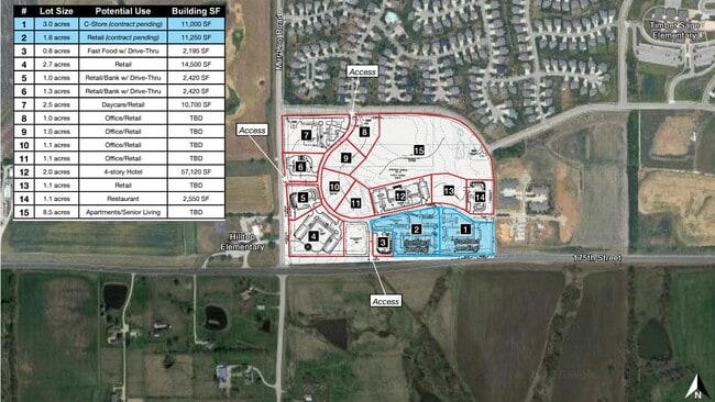
This Property Is For Sale
Property Detail
Ns # Ns
DF241420-2002
20-14-24 BG 740 N SW CR SW1/4 N 403.59 E 1097.14 ELYCUR RT 38.85 S 402.08 W 1135.96 TO POB EX 3.971 AC LYG O/S SD EX PT IN RDS & EX .78 AC PLATTED 5.42 ACS M/L OLC 703 1 1 2
Farms
JOHNSON
CP-2
Kansas
B and X Area of moderate flood hazard, usually the area between the limits of the 100-year and 500-year floods.
1.23 AC
2024
South Johnson County
2025
Kansas City
053414
Kansas City, MO-KS
NEARBY LISTINGS FOR SALE OR LEASE
DEMOGRAPHICS near Ns # Ns
1 mile
3 mile
5 mile
2025 Total Population
2,238
32,169
87,199
2030 Population
2,403
33,501
90,193
Pop Growth 2025-2030
+ 7.37%
+ 4.14%
+ 3.43%
Average Age
39
37
38
2025 Total Households
761
10,530
29,109
HH Growth 2025-2030
+ 7.49%
+ 4.33%
+ 3.52%
Median Household Inc
$178,645
$138,577
$129,987
Avg Household Size
2.90
3.00
2.90
2025 Avg HH Vehicles
2.00
2.00
2.00
Median Home Value
$496,734
$396,562
$394,841
Median Year Built
2011
2003
1997
Nearby Places
Map Layers
Map Styles
 Street
 Aerial
Transit
 Traffic
 Biking
Places
Listings with unknown addresses are not visible on the map
- Restaurants
- Banks
- Shops
- Fitness
- Groceries
Nearby Properties
Address
Land Use
TOTAL SIZE
Lot Size
Zoning
Address
Land Use
TOTAL SIZE
Lot Size
Zoning
320,892 SF
74.58 AC
R-1
Address
Land Use
TOTAL SIZE
Lot Size
Zoning
143,207 SF
16.19 AC
R-1
Address
Land Use
TOTAL SIZE
Lot Size
Zoning
103,102 SF
31.90 AC
R-1
Address
Land Use
TOTAL SIZE
Lot Size
Zoning
137,955 SF
23.80 AC
R-1
Address
Land Use
TOTAL SIZE
Lot Size
Zoning
102,280 SF
30.53 AC
RP-4
Address
Land Use
TOTAL SIZE
Lot Size
Zoning
73,085 SF
18.66 AC
PRN
Address
Land Use
TOTAL SIZE
Lot Size
Zoning
320,891 SF
39.07 AC
M-2
Address
Land Use
TOTAL SIZE
Lot Size
Zoning
71,221 SF
17.13 AC
R-1
Address
Land Use
TOTAL SIZE
Lot Size
Zoning
71,221 SF
13.84 AC
R-1
Address
Land Use
TOTAL SIZE
Lot Size
Zoning
71,221 SF
14.16 AC
Address
Land Use
TOTAL SIZE
Lot Size
Zoning
72,091 SF
11.33 AC
R-1
Address
Land Use
TOTAL SIZE
Lot Size
Zoning
69,723 SF
11.29 AC
R-1
Address
Land Use
TOTAL SIZE
Lot Size
Zoning
65,691 SF
11.51 AC
RP-1
Address
Land Use
TOTAL SIZE
Lot Size
Zoning
62,832 SF
15.43 AC
CTY RUR
Address
Land Use
TOTAL SIZE
Lot Size
Zoning
24,144 SF
11.10 AC
RP-3
Address
Land Use
TOTAL SIZE
Lot Size
Zoning
41,250 SF
6.01 AC
R-R
Address
Land Use
TOTAL SIZE
Lot Size
Zoning
23,219 SF
7.94 AC
CTY RUR
Address
Land Use
TOTAL SIZE
Lot Size
Zoning
53,855 SF
10.17 AC
R-1
Address
Land Use
TOTAL SIZE
Lot Size
Zoning
50,651 SF
9.26 AC
R-1
Address
Land Use
TOTAL SIZE
Lot Size
Zoning
136,176 SF
8.26 AC
RP-3
Address
Land Use
TOTAL SIZE
Lot Size
Zoning
14,884 SF
9.01 AC
M-2
Address
Land Use
TOTAL SIZE
Lot Size
Zoning
23,766 SF
19.91 AC
RUR
Address
Land Use
TOTAL SIZE
Lot Size
Zoning
92.22 AC
R-1
Address
Land Use
TOTAL SIZE
Lot Size
Zoning
9,480 SF
151.19 AC
RN1
Address
Land Use
TOTAL SIZE
Lot Size
Zoning
24,000 SF
3.33 AC
M-2
Address
Land Use
TOTAL SIZE
Lot Size
Zoning
72,000 SF
13.82 AC
R-R
Address
Land Use
TOTAL SIZE
Lot Size
Zoning
79.26 AC
A-J
Address
Land Use
TOTAL SIZE
Lot Size
Zoning
24,324 SF
2.56 AC
M-2
Address
Land Use
TOTAL SIZE
Lot Size
Zoning
93,943 SF
9.34 AC
C-2
Address
Land Use
TOTAL SIZE
Lot Size
Zoning
16,746 SF
4.72 AC
R-1
The World's #1 Commercial Real Estate Marketplace
Connect with us
© 2026 CoStar Group
The information above has been obtained from sources believed reliable. While we do not doubt its accuracy we have not verified it and make no guarantee, warranty or representation about it. It is your responsibility to independently confirm its accuracy and completeness. Any projections, opinions, assumptions, or estimates used are for example only and do not represent the current or future performance of the property. The value of this transaction to you depends on tax and other factors which should be evaluated by your tax, financial, and legal advisors. You and your advisors should conduct a careful, independent investigation of the property to determine to your satisfaction the suitability of the property for your needs.