Property Record
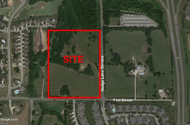
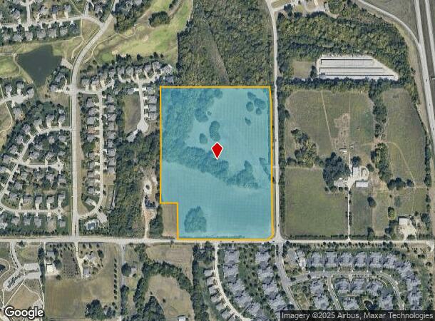
Ns # Ns, Shawnee, KS 66226
NEARBY LISTINGS FOR SALE OR LEASE
Property Detail
Ns # Ns
QF231216-4016
16-12-23 BG 473.91 E SW CR S 1/2 SE1/4 N 330 W 145.20 N 995.13 E 934.02 S 125.30 & 1140 SW 41.10 S 30 W 768.92 TO POB EX .53 AC IN RD 27.35 ACS M/L SHC 332 5
Commercialnec
Johnson
AE
Kansas
20209C0140E
27.19 AC
0
Northwest Johnson County
2024
Kansas City
052604
Kansas City, MO-KS
DEMOGRAPHICS near Ns # Ns
1 Mile
3 Mile
5 Mile
2024 Total Population
4,334
29,915
63,012
2029 Population
4,615
31,350
65,320
Pop Growth 2024-2029
+ 6.48%
+ 4.80%
+ 3.66%
Average Age
41
38
39
2024 Total Households
1,705
10,113
22,818
HH Growth 2024-2029
+ 6.63%
+ 5.03%
+ 3.68%
Median Household Inc
$74,865
$131,731
$119,908
Avg Household Size
2.50
2.90
2.70
2024 Avg HH Vehicles
2.00
2.00
2.00
Median Home Value
$351,286
$370,667
$386,671
Median Year Built
2004
2003
2002
Nearby Places
Map Layers
Map Styles
 Street
 Aerial
- Restaurants
- Banks
- Shops
- Fitness
- Groceries
PUBLIC TRANSPORTATION
AIRPORT
Kansas City International
DRIVE
WALK
Distance
Kansas City International
42 min
35.0 mi
Freight Ports
Tulsa Port Of Catoosa
DRIVE
WALK
Distance
Tulsa Port Of Catoosa
265 min
235.5 mi
SALE & LEASE HISTORY
LISTING DATE
SALE/LEASE

May 11, 2018
For Sale
Nearby Properties
Address
Land Use
TOTAL SIZE
Lot Size
Zoning
Address
Land Use
TOTAL SIZE
Lot Size
Zoning
163,515 SF
70.39 AC
R1
Address
Land Use
TOTAL SIZE
Lot Size
Zoning
202,945 SF
30.29 AC
AG
Address
Land Use
TOTAL SIZE
Lot Size
Zoning
108,062 SF
14.76 AC
AG
Address
Land Use
TOTAL SIZE
Lot Size
Zoning
91,639 SF
19.51 AC
R1
Address
Land Use
TOTAL SIZE
Lot Size
Zoning
32,186 SF
2.80 AC
CH
Address
Land Use
TOTAL SIZE
Lot Size
Zoning
100,591 SF
33.88 AC
AG
Address
Land Use
TOTAL SIZE
Lot Size
Zoning
67,336 SF
26.85 AC
AG
Address
Land Use
TOTAL SIZE
Lot Size
Zoning
99,600 SF
7.77 AC
PI
Address
Land Use
TOTAL SIZE
Lot Size
Zoning
75,626 SF
17.48 AC
AG
Address
Land Use
TOTAL SIZE
Lot Size
Zoning
79,697 SF
11.36 AC
PSF
Address
Land Use
TOTAL SIZE
Lot Size
Zoning
74,420 SF
20.04 AC
AG
Address
Land Use
TOTAL SIZE
Lot Size
Zoning
80,190 SF
16.86 AC
R-1
Address
Land Use
TOTAL SIZE
Lot Size
Zoning
69,923 SF
11.99 AC
AG
Address
Land Use
TOTAL SIZE
Lot Size
Zoning
52,710 SF
29.55 AC
AG
Address
Land Use
TOTAL SIZE
Lot Size
Zoning
39,668 SF
6.02 AC
Address
Land Use
TOTAL SIZE
Lot Size
Zoning
20,832 SF
19.85 AC
AG
Address
Land Use
TOTAL SIZE
Lot Size
Zoning
12,746 SF
8.99 AC
AG
Address
Land Use
TOTAL SIZE
Lot Size
Zoning
19,003 SF
4.47 AC
CH
Address
Land Use
TOTAL SIZE
Lot Size
Zoning
28,390 SF
9.85 AC
AG
Address
Land Use
TOTAL SIZE
Lot Size
Zoning
16,078 SF
19.48 AC
PUDMR
Address
Land Use
TOTAL SIZE
Lot Size
Zoning
161,076 SF
20.27 AC
CH
Address
Land Use
TOTAL SIZE
Lot Size
Zoning
85,059 SF
17.52 AC
RP2
Address
Land Use
TOTAL SIZE
Lot Size
Zoning
46,326 SF
4.01 AC
PI
Address
Land Use
TOTAL SIZE
Lot Size
Zoning
241,418 SF
21.42 AC
PI
Address
Land Use
TOTAL SIZE
Lot Size
Zoning
83.09 AC
AG
Address
Land Use
TOTAL SIZE
Lot Size
Zoning
36,712 SF
8.70 AC
PUDMR
Address
Land Use
TOTAL SIZE
Lot Size
Zoning
9,157 SF
1.46 AC
PUDMR
Address
Land Use
TOTAL SIZE
Lot Size
Zoning
11,519 SF
5.02 AC
PI
Address
Land Use
TOTAL SIZE
Lot Size
Zoning
9,020 SF
9.60 AC
AG
Address
Land Use
TOTAL SIZE
Lot Size
Zoning
73,218 SF
4.78 AC
PUDOC
The World's #1 Commercial Real Estate Marketplace
Connect with us
© 2025 CoStar Group
The information above has been obtained from sources believed reliable. While we do not doubt its accuracy we have not verified it and make no guarantee, warranty or representation about it. It is your responsibility to independently confirm its accuracy and completeness. Any projections, opinions, assumptions, or estimates used are for example only and do not represent the current or future performance of the property. The value of this transaction to you depends on tax and other factors which should be evaluated by your tax, financial, and legal advisors. You and your advisors should conduct a careful, independent investigation of the property to determine to your satisfaction the suitability of the property for your needs.