Property Record
Ns Nt, Lenexa, KS


Property Detail
Ns Nt
IF231302-4008
2-13-23 NE1/4 SE1/4 EX 7.14 AC EX 7 TRS PLATTED 7.3926 AC .816 AC 3.483 AC 2.7 AC 4.239 AC EX 1.521 AC & 3.33 AC & EX .851 AC IN ST EX 1.031 AC EX 2.111 AC & EX 1.61 AC 3.7754 ACS M/L
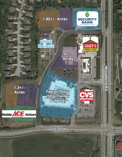
Parkinglot
JOHNSON
CP2
Kansas
B and X Area of moderate flood hazard, usually the area between the limits of the 100-year and 500-year floods.
2.91 AC
2024
Northwest Johnson County
2025
Kansas City
052608
Kansas City, MO-KS
NEARBY LISTINGS FOR SALE OR LEASE
DEMOGRAPHICS near Ns Nt
1 mile
3 mile
5 mile
2024 Total Population
5,407
37,401
143,577
2029 Population
5,653
39,539
150,052
Pop Growth 2024-2029
+ 4.55%
+ 5.72%
+ 4.51%
Average Age
41
40
39
2024 Total Households
1,933
14,622
55,805
HH Growth 2024-2029
+ 4.60%
+ 5.81%
+ 4.59%
Median Household Inc
$149,433
$115,396
$94,691
Avg Household Size
2.70
2.50
2.50
2024 Avg HH Vehicles
2.00
2.00
2.00
Median Home Value
$460,603
$398,170
$328,598
Median Year Built
2006
2005
1993
Nearby Places
Map Layers
Map Styles
 Street
 Aerial
Transit
 Traffic
 Biking
Places
Listings with unknown addresses are not visible on the map
- Restaurants
- Banks
- Shops
- Fitness
- Groceries
PUBLIC TRANSPORTATION
AIRPORT
Kansas City International
Drive
Walk
Distance
Kansas City International
46 min
36.9 mi
SALE & LEASE HISTORY
LISTING DATE
SALE/LEASE

Feb 22, 2019
For Lease
Nearby Properties
Address
Land Use
TOTAL SIZE
Lot Size
Zoning
Address
Land Use
TOTAL SIZE
Lot Size
Zoning
290,674 SF
74.32 AC
RP-1
Address
Land Use
TOTAL SIZE
Lot Size
Zoning
162,499 SF
38.74 AC
R-1
Address
Land Use
TOTAL SIZE
Lot Size
Zoning
88,459 SF
15.13 AC
R-1
Address
Land Use
TOTAL SIZE
Lot Size
Zoning
204,792 SF
15.20 AC
RP-3
Address
Land Use
TOTAL SIZE
Lot Size
Zoning
635,676 SF
30.59 AC
BP2
Address
Land Use
TOTAL SIZE
Lot Size
Zoning
564,948 SF
27.40 AC
AG
Address
Land Use
TOTAL SIZE
Lot Size
Zoning
208,693 SF
22.30 AC
BP1
Address
Land Use
TOTAL SIZE
Lot Size
Zoning
211,785 SF
35.56 AC
RP-3
Address
Land Use
TOTAL SIZE
Lot Size
Zoning
133,932 SF
3.29 AC
CC
Address
Land Use
TOTAL SIZE
Lot Size
Zoning
144,755 SF
22.19 AC
BP2
Address
Land Use
TOTAL SIZE
Lot Size
Zoning
106,283 SF
11.79 AC
R1
Address
Land Use
TOTAL SIZE
Lot Size
Zoning
304,926 SF
7.87 AC
CC
Address
Land Use
TOTAL SIZE
Lot Size
Zoning
146,926 SF
29.23 AC
R-1
Address
Land Use
TOTAL SIZE
Lot Size
Zoning
129,784 SF
36.15 AC
CPO
Address
Land Use
TOTAL SIZE
Lot Size
Zoning
404,388 SF
21.55 AC
BP2
Address
Land Use
TOTAL SIZE
Lot Size
Zoning
49,029 SF
15.02 AC
BP1
Address
Land Use
TOTAL SIZE
Lot Size
Zoning
69,872 SF
1.91 AC
CC
Address
Land Use
TOTAL SIZE
Lot Size
Zoning
347,324 SF
18.16 AC
BP2
Address
Land Use
TOTAL SIZE
Lot Size
Zoning
68,131 SF
6.01 AC
Address
Land Use
TOTAL SIZE
Lot Size
Zoning
91,639 SF
19.51 AC
R1
Address
Land Use
TOTAL SIZE
Lot Size
Zoning
192,548 SF
20.09 AC
BP
Address
Land Use
TOTAL SIZE
Lot Size
Zoning
141,340 SF
19.92 AC
R1
Address
Land Use
TOTAL SIZE
Lot Size
Zoning
69,675 SF
11.85 AC
R1
Address
Land Use
TOTAL SIZE
Lot Size
Zoning
75,010 SF
24.78 AC
RP2
Address
Land Use
TOTAL SIZE
Lot Size
Zoning
267,668 SF
17.36 AC
BP2
Address
Land Use
TOTAL SIZE
Lot Size
Zoning
204,922 SF
14.73 AC
BP2
Address
Land Use
TOTAL SIZE
Lot Size
Zoning
138,758 SF
36.62 AC
BP
Address
Land Use
TOTAL SIZE
Lot Size
Zoning
71,146 SF
12.67 AC
CP-2
Address
Land Use
TOTAL SIZE
Lot Size
Zoning
36,903 SF
0.55 AC
CC
Address
Land Use
TOTAL SIZE
Lot Size
Zoning
99,600 SF
7.77 AC
PI
The World's #1 Commercial Real Estate Marketplace
Connect with us
© 2026 CoStar Group
The information above has been obtained from sources believed reliable. While we do not doubt its accuracy we have not verified it and make no guarantee, warranty or representation about it. It is your responsibility to independently confirm its accuracy and completeness. Any projections, opinions, assumptions, or estimates used are for example only and do not represent the current or future performance of the property. The value of this transaction to you depends on tax and other factors which should be evaluated by your tax, financial, and legal advisors. You and your advisors should conduct a careful, independent investigation of the property to determine to your satisfaction the suitability of the property for your needs.