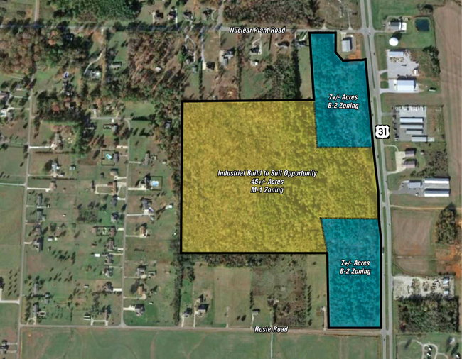
Property Record
Nuclear Plant Rd Highway 31, Tanner, AL 35671


NEARBY LISTINGS FOR SALE OR LEASE
Property Detail
Nuclear Plant Rd Highway 31
Huntsville, AL
Tanner Estates
16-02-09-0-001-054.000
TANNER ESTATES LOTS 30 THRU 35 PLAT F\79-82 SEC 5 4 4
Miscellaneous
Limestone
X
Alabama
01083C0279F
30 - 35
2025
5.90 AC
2024
Outlying Limestone County
021101
Huntsville
DEMOGRAPHICS near Nuclear Plant Rd Highway 31
1 Mile
3 Mile
5 Mile
2024 Total Population
1,099
2,967
11,543
2029 Population
1,310
3,526
13,658
Pop Growth 2024-2029
+ 19.20%
+ 18.84%
+ 18.32%
Average Age
44
43
42
2024 Total Households
451
1,184
4,598
HH Growth 2024-2029
+ 19.73%
+ 19.34%
+ 18.77%
Median Household Inc
$52,386
$53,705
$76,015
Avg Household Size
2.40
2.50
2.50
2024 Avg HH Vehicles
2.00
2.00
2.00
Median Home Value
$264,788
$250,000
$274,395
Median Year Built
1995
1992
1994
Nearby Places
Map Layers
Map Styles
 Street
 Aerial
- Restaurants
- Banks
- Shops
- Fitness
- Groceries
PUBLIC TRANSPORTATION
AIRPORT
Huntsville International-Carl T Jones Field
DRIVE
WALK
Distance
Huntsville International-Carl T Jones Field
26 min
19.0 mi
Freight Ports
Port of Mobile
DRIVE
WALK
Distance
Port of Mobile
376 min
344.0 mi
SALE & LEASE HISTORY
LISTING DATE
SALE/LEASE

Nov 03, 2022
For Sale
Jan 15, 2020
For Sale
Nearby Properties
Address
Land Use
TOTAL SIZE
Lot Size
Zoning
Address
Land Use
TOTAL SIZE
Lot Size
Zoning
55,196 SF
21.21 AC
Address
Land Use
TOTAL SIZE
Lot Size
Zoning
Address
Land Use
TOTAL SIZE
Lot Size
Zoning
2,156 SF
107 AC
Address
Land Use
TOTAL SIZE
Lot Size
Zoning
Address
Land Use
TOTAL SIZE
Lot Size
Zoning
568 SF
8.25 AC
Address
Land Use
TOTAL SIZE
Lot Size
Zoning
52,644 SF
10 AC
Address
Land Use
TOTAL SIZE
Lot Size
Zoning
27,360 SF
4.80 AC
Address
Land Use
TOTAL SIZE
Lot Size
Zoning
20,225 SF
4 AC
Address
Land Use
TOTAL SIZE
Lot Size
Zoning
196.30 AC
Address
Land Use
TOTAL SIZE
Lot Size
Zoning
18,462 SF
2.90 AC
Address
Land Use
TOTAL SIZE
Lot Size
Zoning
2,400 SF
19.86 AC
Address
Land Use
TOTAL SIZE
Lot Size
Zoning
17,196 SF
3 AC
Address
Land Use
TOTAL SIZE
Lot Size
Zoning
11,139 SF
2 AC
Address
Land Use
TOTAL SIZE
Lot Size
Zoning
8,960 SF
0.51 AC
Address
Land Use
TOTAL SIZE
Lot Size
Zoning
219 AC
Address
Land Use
TOTAL SIZE
Lot Size
Zoning
8,250 SF
1.20 AC
Address
Land Use
TOTAL SIZE
Lot Size
Zoning
11,924 SF
3 AC
Address
Land Use
TOTAL SIZE
Lot Size
Zoning
15.50 AC
Address
Land Use
TOTAL SIZE
Lot Size
Zoning
7,296 SF
3.50 AC
Address
Land Use
TOTAL SIZE
Lot Size
Zoning
700 SF
62 AC
Address
Land Use
TOTAL SIZE
Lot Size
Zoning
15,566 SF
1.90 AC
Address
Land Use
TOTAL SIZE
Lot Size
Zoning
7,037 SF
2.01 AC
Address
Land Use
TOTAL SIZE
Lot Size
Zoning
12,770 SF
3 AC
Address
Land Use
TOTAL SIZE
Lot Size
Zoning
5,000 SF
1 AC
Address
Land Use
TOTAL SIZE
Lot Size
Zoning
10.60 AC
Address
Land Use
TOTAL SIZE
Lot Size
Zoning
89.26 AC
Address
Land Use
TOTAL SIZE
Lot Size
Zoning
146 AC
Address
Land Use
TOTAL SIZE
Lot Size
Zoning
72 AC
Address
Land Use
TOTAL SIZE
Lot Size
Zoning
6,000 SF
0.51 AC
Address
Land Use
TOTAL SIZE
Lot Size
Zoning
6,572 SF
3.20 AC
The World's #1 Commercial Real Estate Marketplace
Connect with us
© 2025 CoStar Group
The information above has been obtained from sources believed reliable. While we do not doubt its accuracy we have not verified it and make no guarantee, warranty or representation about it. It is your responsibility to independently confirm its accuracy and completeness. Any projections, opinions, assumptions, or estimates used are for example only and do not represent the current or future performance of the property. The value of this transaction to you depends on tax and other factors which should be evaluated by your tax, financial, and legal advisors. You and your advisors should conduct a careful, independent investigation of the property to determine to your satisfaction the suitability of the property for your needs.