Property Record
Null, Tyrone, GA 30290

Property Detail
Null
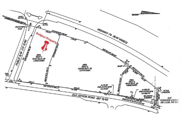
07-26-00-036
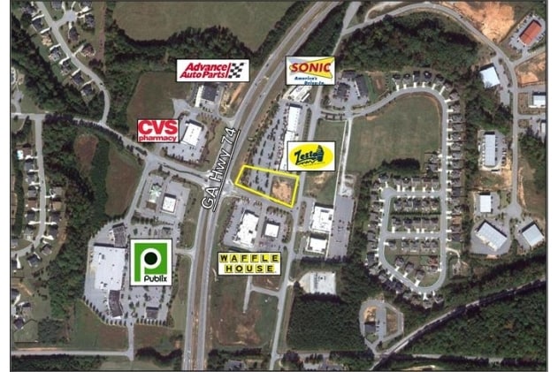
1.40 ACRES HWY 74 N & CARRIAGE
Commercialacreage
FAYETTE
C C2
Georgia
B and X Area of moderate flood hazard, usually the area between the limits of the 100-year and 500-year floods.
1.40 AC
2024
Fayette/Coweta County
2025
Atlanta
140203
Atlanta-Sandy Springs-Roswell, GA
NEARBY LISTINGS FOR SALE OR LEASE
DEMOGRAPHICS near Null
1 mile
3 mile
5 mile
2025 Total Population
2,059
14,306
53,855
2030 Population
2,125
14,973
56,281
Pop Growth 2025-2030
+ 3.21%
+ 4.66%
+ 4.50%
Average Age
41
41
41
2025 Total Households
660
4,789
19,558
HH Growth 2025-2030
+ 3.48%
+ 4.74%
+ 4.38%
Median Household Inc
$122,142
$103,178
$103,498
Avg Household Size
3.10
3.00
2.70
2025 Avg HH Vehicles
2.00
2.00
2.00
Median Home Value
$465,624
$416,916
$437,463
Median Year Built
1999
1997
1999
Nearby Places
Map Layers
Map Styles
 Street
 Aerial
Transit
 Traffic
 Biking
Places
Listings with unknown addresses are not visible on the map
- Restaurants
- Banks
- Shops
- Fitness
- Groceries
PUBLIC TRANSPORTATION
AIRPORT
Hartsfield - Jackson Atlanta International
Drive
Walk
Distance
Hartsfield - Jackson Atlanta International
28 min
18.4 mi
SALE & LEASE HISTORY
LISTING DATE
SALE/LEASE

Aug 28, 2017
For Sale
Nearby Properties
Address
Land Use
TOTAL SIZE
Lot Size
Zoning
Address
Land Use
TOTAL SIZE
Lot Size
Zoning
907,675 SF
73.12 AC
AG1
Address
Land Use
TOTAL SIZE
Lot Size
Zoning
412,253 SF
134.50 AC
Address
Land Use
TOTAL SIZE
Lot Size
Zoning
80,800 SF
9.39 AC
C C2
Address
Land Use
TOTAL SIZE
Lot Size
Zoning
598,814 SF
120.60 AC
Address
Land Use
TOTAL SIZE
Lot Size
Zoning
80,956 SF
60.90 AC
Address
Land Use
TOTAL SIZE
Lot Size
Zoning
72,376 SF
30.30 AC
Address
Land Use
TOTAL SIZE
Lot Size
Zoning
90,360 SF
5.86 AC
C2
Address
Land Use
TOTAL SIZE
Lot Size
Zoning
60.89 AC
I M1
Address
Land Use
TOTAL SIZE
Lot Size
Zoning
30,397 SF
24.50 AC
Address
Land Use
TOTAL SIZE
Lot Size
Zoning
13.89 AC
Address
Land Use
TOTAL SIZE
Lot Size
Zoning
12,859 SF
50.50 AC
Address
Land Use
TOTAL SIZE
Lot Size
Zoning
15,440 SF
10.86 AC
C C1
Address
Land Use
TOTAL SIZE
Lot Size
Zoning
17,248 SF
3.47 AC
C OI
Address
Land Use
TOTAL SIZE
Lot Size
Zoning
26,022 SF
3.48 AC
C C2
Address
Land Use
TOTAL SIZE
Lot Size
Zoning
11,780 SF
2.07 AC
C2
Address
Land Use
TOTAL SIZE
Lot Size
Zoning
24,100 SF
4.30 AC
C C3
Address
Land Use
TOTAL SIZE
Lot Size
Zoning
1,080 SF
37.60 AC
I M1
Address
Land Use
TOTAL SIZE
Lot Size
Zoning
27,270 SF
3.28 AC
C C2
Address
Land Use
TOTAL SIZE
Lot Size
Zoning
18,400 SF
2.35 AC
C C1
Address
Land Use
TOTAL SIZE
Lot Size
Zoning
720 SF
14.23 AC
AG1
Address
Land Use
TOTAL SIZE
Lot Size
Zoning
60,099 SF
3.60 AC
Address
Land Use
TOTAL SIZE
Lot Size
Zoning
56,280 SF
4.04 AC
OI
Address
Land Use
TOTAL SIZE
Lot Size
Zoning
14,375 SF
1.85 AC
C C1
Address
Land Use
TOTAL SIZE
Lot Size
Zoning
24,033 SF
2.65 AC
C1
Address
Land Use
TOTAL SIZE
Lot Size
Zoning
17,330 SF
4.16 AC
C OI
Address
Land Use
TOTAL SIZE
Lot Size
Zoning
15,512 SF
11.26 AC
Address
Land Use
TOTAL SIZE
Lot Size
Zoning
30,000 SF
9.45 AC
C C2
Address
Land Use
TOTAL SIZE
Lot Size
Zoning
13,914 SF
1.74 AC
C C2
Address
Land Use
TOTAL SIZE
Lot Size
Zoning
62,322 SF
25.50 AC
I M1
Address
Land Use
TOTAL SIZE
Lot Size
Zoning
6,940 SF
1.65 AC
C C2
The World's #1 Commercial Real Estate Marketplace
Connect with us
© 2026 CoStar Group
The information above has been obtained from sources believed reliable. While we do not doubt its accuracy we have not verified it and make no guarantee, warranty or representation about it. It is your responsibility to independently confirm its accuracy and completeness. Any projections, opinions, assumptions, or estimates used are for example only and do not represent the current or future performance of the property. The value of this transaction to you depends on tax and other factors which should be evaluated by your tax, financial, and legal advisors. You and your advisors should conduct a careful, independent investigation of the property to determine to your satisfaction the suitability of the property for your needs.