Property Record
2790 W Baseline Rd, Laveen, AZ 85339
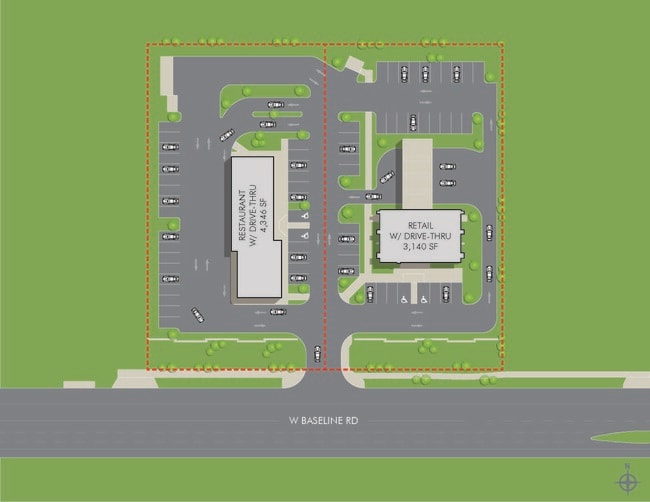


This Property Is For Sale
Current Lease Availabilities
Property Detail
2790 W Baseline Rd
Phoenix-Mesa-Chandler, AZ
W 300F OF E 870F OF S2 S2 SE4 SE4 SEC 35 EX S 55F P/F 23-0268314
105-88-982
MARICOPA
Residentialacreage
Arizona
2025
1.89 AC
2025
Laveen
116612
Phoenix
NEARBY LISTINGS FOR SALE OR LEASE
DEMOGRAPHICS near 2790 W Baseline Rd
1 mile
3 mile
5 mile
2025 Total Population
12,127
95,502
186,081
2030 Population
12,714
99,995
195,452
Pop Growth 2025-2030
+ 4.84%
+ 4.70%
+ 5.04%
Average Age
35
35
35
2025 Total Households
3,572
27,073
54,129
HH Growth 2025-2030
+ 4.87%
+ 4.81%
+ 5.09%
Median Household Inc
$101,231
$81,009
$75,223
Avg Household Size
3.40
3.40
3.30
2025 Avg HH Vehicles
2.00
2.00
2.00
Median Home Value
$434,640
$399,319
$399,218
Median Year Built
2006
2003
2001
Nearby Places
Map Layers
Map Styles
 Street
 Aerial
Layers
 Traffic
 Biking
Places
Listings with unknown addresses are not visible on the map
- Restaurants
- Banks
- Shops
- Fitness
- Groceries
PUBLIC TRANSPORTATION
AIRPORT
Phoenix Sky Harbor International
Drive
Walk
Distance
Phoenix Sky Harbor International
21 min
11.3 mi
Phoenix-Mesa Gateway
Drive
Walk
Distance
Phoenix-Mesa Gateway
48 min
32.0 mi
Freight Ports
Port of San Diego
Drive
Walk
Distance
Port of San Diego
401 min
358.2 mi
Nearby Properties
Address
Land Use
TOTAL SIZE
Lot Size
Zoning
Address
Land Use
TOTAL SIZE
Lot Size
Zoning
182,984 SF
146.12 AC
I-1
Address
Land Use
TOTAL SIZE
Lot Size
Zoning
47,597 SF
22.74 AC
R-43
Address
Land Use
TOTAL SIZE
Lot Size
Zoning
367,953 SF
38.18 AC
R-43AG
Address
Land Use
TOTAL SIZE
Lot Size
Zoning
10 SF
644.14 AC
R-35
Address
Land Use
TOTAL SIZE
Lot Size
Zoning
398,815 SF
12.72 AC
C2
Address
Land Use
TOTAL SIZE
Lot Size
Zoning
6.55 AC
C-G
Address
Land Use
TOTAL SIZE
Lot Size
Zoning
70,951 SF
336.40 AC
R-43AG
Address
Land Use
TOTAL SIZE
Lot Size
Zoning
233,156 SF
15.77 AC
R3A
Address
Land Use
TOTAL SIZE
Lot Size
Zoning
93,310 SF
9.16 AC
R-6
Address
Land Use
TOTAL SIZE
Lot Size
Zoning
95,854 SF
15.11 AC
R-43AG
Address
Land Use
TOTAL SIZE
Lot Size
Zoning
70,152 SF
180.34 AC
RE35
Address
Land Use
TOTAL SIZE
Lot Size
Zoning
91,949 SF
19.14 AC
R-43
Address
Land Use
TOTAL SIZE
Lot Size
Zoning
9,222 SF
171.26 AC
I-1
Address
Land Use
TOTAL SIZE
Lot Size
Zoning
93,600 SF
51.60 AC
A2
Address
Land Use
TOTAL SIZE
Lot Size
Zoning
416,645 SF
18.80 AC
M-H
Address
Land Use
TOTAL SIZE
Lot Size
Zoning
219,555 SF
21.25 AC
C2
Address
Land Use
TOTAL SIZE
Lot Size
Zoning
91,063 SF
12 AC
R-43AG
Address
Land Use
TOTAL SIZE
Lot Size
Zoning
101,619 SF
13.71 AC
R-8
Address
Land Use
TOTAL SIZE
Lot Size
Zoning
186,437 SF
17.85 AC
PAD-HD
Address
Land Use
TOTAL SIZE
Lot Size
Zoning
103,111 SF
12.13 AC
R-43
Address
Land Use
TOTAL SIZE
Lot Size
Zoning
139,410 SF
14.41 AC
C-C
Address
Land Use
TOTAL SIZE
Lot Size
Zoning
118,842 SF
5.10 AC
R3
Address
Land Use
TOTAL SIZE
Lot Size
Zoning
92,917 SF
14.54 AC
Address
Land Use
TOTAL SIZE
Lot Size
Zoning
8,880 SF
1.99 AC
I-2
Address
Land Use
TOTAL SIZE
Lot Size
Zoning
39,000 SF
3.92 AC
C-C
Address
Land Use
TOTAL SIZE
Lot Size
Zoning
58,603 SF
12.15 AC
R-43AG
Address
Land Use
TOTAL SIZE
Lot Size
Zoning
64,031 SF
14.68 AC
R-43AG
Address
Land Use
TOTAL SIZE
Lot Size
Zoning
63,002 SF
11.61 AC
R-6
Address
Land Use
TOTAL SIZE
Lot Size
Zoning
78,576 SF
8.69 AC
R-10
Address
Land Use
TOTAL SIZE
Lot Size
Zoning
8,029 SF
2.19 AC
R-4
The World's #1 Commercial Real Estate Marketplace
Connect with us
© 2026 CoStar Group
The information above has been obtained from sources believed reliable. While we do not doubt its accuracy we have not verified it and make no guarantee, warranty or representation about it. It is your responsibility to independently confirm its accuracy and completeness. Any projections, opinions, assumptions, or estimates used are for example only and do not represent the current or future performance of the property. The value of this transaction to you depends on tax and other factors which should be evaluated by your tax, financial, and legal advisors. You and your advisors should conduct a careful, independent investigation of the property to determine to your satisfaction the suitability of the property for your needs.