Property Record
Nw Corner Carefree Hwy, Carefree, AZ 85377
NEARBY LISTINGS FOR SALE OR LEASE
Property Detail
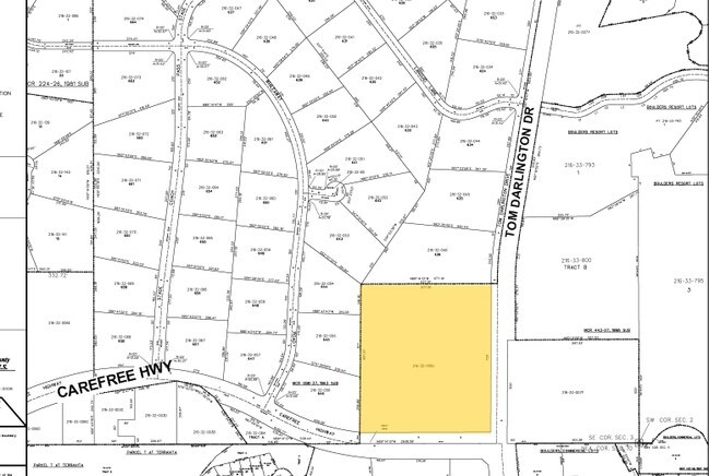
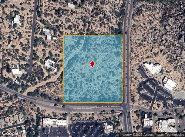
Nw Corner Carefree Hwy
Phoenix-Mesa-Scottsdale, AZ
Carefree Plat 3B
216-32-008J
TH PT SE4 SE4 SEC 3 DAF COM SE COR SEC TH W 667.16F TO POB TH N 772.63F TH W 667.16F TH S 772.63F TO S LN SEC TH E ALG SD S LN TO POB EX E 50F RD & EX RD DESC P/D 10379-718
Residentialacreage
Maricopa
AE
Arizona
04013C0891M
10.35 AC
2025
N Scottsdale/Carefree
2025
Phoenix
030401
DEMOGRAPHICS near Nw Corner Carefree Hwy
1 Mile
3 Mile
5 Mile
2024 Total Population
3,479
23,439
51,283
2029 Population
3,899
25,882
56,274
Pop Growth 2024-2029
+ 12.07%
+ 10.42%
+ 9.73%
Average Age
62
55
52
2024 Total Households
1,643
10,369
21,837
HH Growth 2024-2029
+ 12.23%
+ 10.65%
+ 10.00%
Median Household Inc
$154,867
$134,486
$132,685
Avg Household Size
2.10
2.20
2.30
2024 Avg HH Vehicles
2.00
2.00
2.00
Median Home Value
$789,757
$788,323
$759,167
Median Year Built
1996
1998
1998
Nearby Places
Map Layers
Map Styles
 Street
 Aerial
- Restaurants
- Banks
- Shops
- Fitness
- Groceries
PUBLIC TRANSPORTATION
AIRPORT
Phoenix Sky Harbor International
DRIVE
WALK
Distance
Phoenix Sky Harbor International
47 min
32.2 mi
Freight Ports
Port of San Diego
DRIVE
WALK
Distance
Port of San Diego
431 min
381.6 mi
Nearby Properties
Address
Land Use
TOTAL SIZE
Lot Size
Zoning
Address
Land Use
TOTAL SIZE
Lot Size
Zoning
557,887 SF
163.54 AC
R-43
Address
Land Use
TOTAL SIZE
Lot Size
Zoning
170,385 SF
23.82 AC
C-C
Address
Land Use
TOTAL SIZE
Lot Size
Zoning
140,303 SF
29.18 AC
R-4R
Address
Land Use
TOTAL SIZE
Lot Size
Zoning
123,518 SF
14.92 AC
C-C
Address
Land Use
TOTAL SIZE
Lot Size
Zoning
10 SF
13.75 AC
R-35
Address
Land Use
TOTAL SIZE
Lot Size
Zoning
126,785 SF
17.94 AC
C-G
Address
Land Use
TOTAL SIZE
Lot Size
Zoning
55,995 SF
17.95 AC
R-35
Address
Land Use
TOTAL SIZE
Lot Size
Zoning
30,172 SF
14.13 AC
S1
Address
Land Use
TOTAL SIZE
Lot Size
Zoning
223,188 SF
13.68 AC
RT
Address
Land Use
TOTAL SIZE
Lot Size
Zoning
115,432 SF
12.98 AC
C-C
Address
Land Use
TOTAL SIZE
Lot Size
Zoning
67,241 SF
9.40 AC
R-43
Address
Land Use
TOTAL SIZE
Lot Size
Zoning
130,394 SF
10.22 AC
C-2
Address
Land Use
TOTAL SIZE
Lot Size
Zoning
82,175 SF
8.65 AC
C-C
Address
Land Use
TOTAL SIZE
Lot Size
Zoning
47,830 SF
5.22 AC
R-43
Address
Land Use
TOTAL SIZE
Lot Size
Zoning
84,248 SF
6.68 AC
C-C
Address
Land Use
TOTAL SIZE
Lot Size
Zoning
140,290 SF
5.13 AC
CP/GCP
Address
Land Use
TOTAL SIZE
Lot Size
Zoning
45,425 SF
22.94 AC
R-43AG
Address
Land Use
TOTAL SIZE
Lot Size
Zoning
35,734 SF
10.13 AC
R-43
Address
Land Use
TOTAL SIZE
Lot Size
Zoning
32,944 SF
6.89 AC
R-70
Address
Land Use
TOTAL SIZE
Lot Size
Zoning
60,652 SF
6.82 AC
C-C
Address
Land Use
TOTAL SIZE
Lot Size
Zoning
31,823 SF
1.80 AC
R-43
Address
Land Use
TOTAL SIZE
Lot Size
Zoning
65,744 SF
2.05 AC
Address
Land Use
TOTAL SIZE
Lot Size
Zoning
21,828 SF
58.46 AC
R-43
Address
Land Use
TOTAL SIZE
Lot Size
Zoning
38,754 SF
205.79 AC
R1-130
Address
Land Use
TOTAL SIZE
Lot Size
Zoning
15,261 SF
13.02 AC
R135
Address
Land Use
TOTAL SIZE
Lot Size
Zoning
38,493 SF
1.88 AC
C-C
Address
Land Use
TOTAL SIZE
Lot Size
Zoning
31,318 SF
5.37 AC
C-C
Address
Land Use
TOTAL SIZE
Lot Size
Zoning
27,058 SF
8.21 AC
O-S
Address
Land Use
TOTAL SIZE
Lot Size
Zoning
2.88 AC
R-43
The World's #1 Commercial Real Estate Marketplace
Connect with us
© 2025 CoStar Group
The information above has been obtained from sources believed reliable. While we do not doubt its accuracy we have not verified it and make no guarantee, warranty or representation about it. It is your responsibility to independently confirm its accuracy and completeness. Any projections, opinions, assumptions, or estimates used are for example only and do not represent the current or future performance of the property. The value of this transaction to you depends on tax and other factors which should be evaluated by your tax, financial, and legal advisors. You and your advisors should conduct a careful, independent investigation of the property to determine to your satisfaction the suitability of the property for your needs.