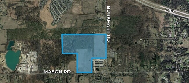
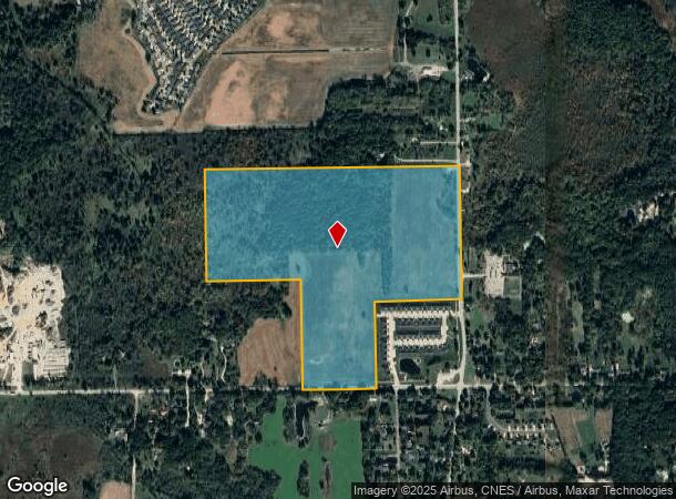
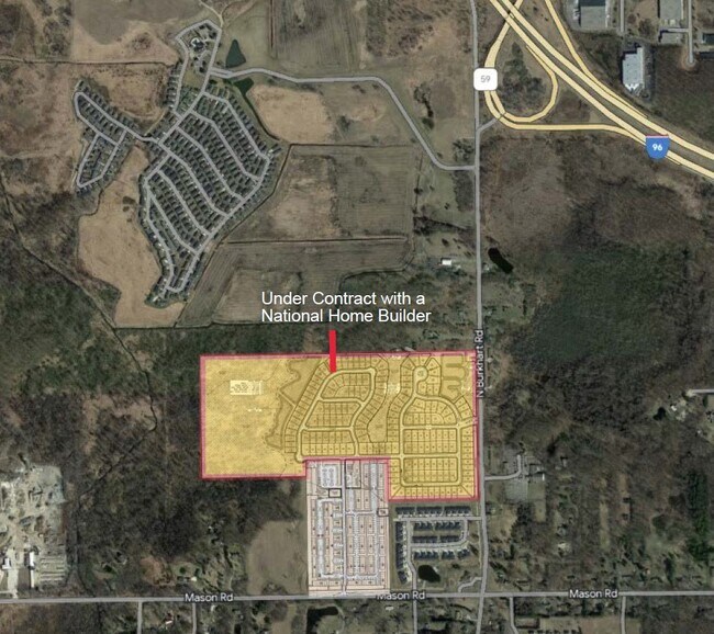
Property Record
Mason Rd, Howell, MI 48843
NEARBY LISTINGS FOR SALE OR LEASE
Property Detail
Mason Rd
06-32-400-013
SEC 32 T3N R4E COMM AT SE 1/4 COR SEC 32 TH S 89^ 55' 08" W 903.41 FT FOR POB TH S 89^ 55' 06" W 769.27 FT TH N 00^ 05' 59" E
Residentialacreage
Livingston
A
Michigan
26093C0301D
95.32 AC
2025
Livingston County
2025
Detroit
742403
Detroit-Warren-Dearborn, MI
DEMOGRAPHICS near Mason Rd
1 mile
3 mile
5 mile
2024 Total Population
1,716
9,415
32,517
2029 Population
1,747
9,620
33,429
Pop Growth 2024-2029
+ 1.81%
+ 2.18%
+ 2.80%
Average Age
42
42
41
2024 Total Households
658
3,580
12,818
HH Growth 2024-2029
+ 1.67%
+ 2.09%
+ 2.79%
Median Household Inc
$85,416
$84,278
$80,207
Avg Household Size
2.60
2.50
2.50
2024 Avg HH Vehicles
2.00
2.00
2.00
Median Home Value
$251,655
$261,044
$258,634
Median Year Built
1996
1992
1991
Nearby Places
Map Layers
Map Styles
 Street
 Aerial
Transit
 Traffic
 Biking
Places
Listings with unknown addresses are not visible on the map
- Restaurants
- Banks
- Shops
- Fitness
- Groceries
PUBLIC TRANSPORTATION
AIRPORT
Bishop International
Drive
Walk
Distance
Bishop International
61 min
39.5 mi
Freight Ports
Port of Toledo
Drive
Walk
Distance
Port of Toledo
111 min
92.4 mi
SALE & LEASE HISTORY
LISTING DATE
SALE/LEASE

Mar 15, 2022
For Sale
Nearby Properties
Address
Land Use
TOTAL SIZE
Lot Size
Zoning
Address
Land Use
TOTAL SIZE
Lot Size
Zoning
767,161 SF
127.33 AC
I-1
Address
Land Use
TOTAL SIZE
Lot Size
Zoning
331,100 SF
41.10 AC
RSC
Address
Land Use
TOTAL SIZE
Lot Size
Zoning
344,387 SF
27.72 AC
I-1
Address
Land Use
TOTAL SIZE
Lot Size
Zoning
89,443 SF
10.45 AC
R-M
Address
Land Use
TOTAL SIZE
Lot Size
Zoning
102,971 SF
11.95 AC
I-1
Address
Land Use
TOTAL SIZE
Lot Size
Zoning
171,564 SF
30.98 AC
O-1
Address
Land Use
TOTAL SIZE
Lot Size
Zoning
321,167 SF
27.01 AC
IFZ
Address
Land Use
TOTAL SIZE
Lot Size
Zoning
145,366 SF
13.60 AC
R-M
Address
Land Use
TOTAL SIZE
Lot Size
Zoning
37.65 AC
MFR
Address
Land Use
TOTAL SIZE
Lot Size
Zoning
24,644 SF
160 AC
R&D
Address
Land Use
TOTAL SIZE
Lot Size
Zoning
6,837 SF
128.76 AC
MHP
Address
Land Use
TOTAL SIZE
Lot Size
Zoning
152,606 SF
16 AC
R-M
Address
Land Use
TOTAL SIZE
Lot Size
Zoning
16.65 AC
MFR
Address
Land Use
TOTAL SIZE
Lot Size
Zoning
106,170 SF
6.68 AC
I
Address
Land Use
TOTAL SIZE
Lot Size
Zoning
119,260 SF
7.10 AC
IFZ
Address
Land Use
TOTAL SIZE
Lot Size
Zoning
154,040 SF
13.70 AC
I
Address
Land Use
TOTAL SIZE
Lot Size
Zoning
112,419 SF
9.31 AC
I
Address
Land Use
TOTAL SIZE
Lot Size
Zoning
107,867 SF
26.53 AC
AR
Address
Land Use
TOTAL SIZE
Lot Size
Zoning
119,436 SF
12.20 AC
I-1
Address
Land Use
TOTAL SIZE
Lot Size
Zoning
128,437 SF
8.55 AC
IFZ
Address
Land Use
TOTAL SIZE
Lot Size
Zoning
122,040 SF
9.81 AC
I
Address
Land Use
TOTAL SIZE
Lot Size
Zoning
22,660 SF
4.80 AC
IFZ
Address
Land Use
TOTAL SIZE
Lot Size
Zoning
81.26 AC
MHP
Address
Land Use
TOTAL SIZE
Lot Size
Zoning
55,100 SF
5 AC
NSC
Address
Land Use
TOTAL SIZE
Lot Size
Zoning
56,205 SF
3.68 AC
RSC
Address
Land Use
TOTAL SIZE
Lot Size
Zoning
54,662 SF
5.65 AC
RSC
Address
Land Use
TOTAL SIZE
Lot Size
Zoning
53,448 SF
5.16 AC
IFZ
Address
Land Use
TOTAL SIZE
Lot Size
Zoning
13.92 AC
IFZ
Address
Land Use
TOTAL SIZE
Lot Size
Zoning
50,496 SF
5.53 AC
R-M
Address
Land Use
TOTAL SIZE
Lot Size
Zoning
70,725 SF
125.03 AC
I-1
The World's #1 Commercial Real Estate Marketplace
Connect with us
© 2026 CoStar Group
The information above has been obtained from sources believed reliable. While we do not doubt its accuracy we have not verified it and make no guarantee, warranty or representation about it. It is your responsibility to independently confirm its accuracy and completeness. Any projections, opinions, assumptions, or estimates used are for example only and do not represent the current or future performance of the property. The value of this transaction to you depends on tax and other factors which should be evaluated by your tax, financial, and legal advisors. You and your advisors should conduct a careful, independent investigation of the property to determine to your satisfaction the suitability of the property for your needs.