Property Record
Nw Limestone Heights St, Arcadia, FL 34266
NEARBY LISTINGS FOR SALE OR LEASE
Property Detail
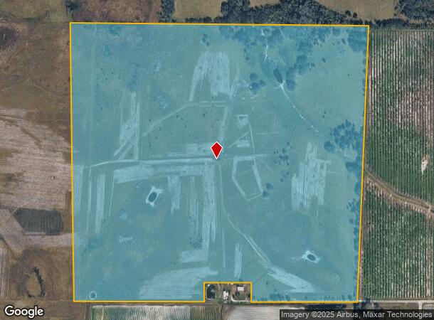
Nw Limestone Heights St
03-37-24-0000-0041-0000
NW1/4 LESS PARCEL 0040 SUBJ TO ESMT OR 470/636 INST:202314010696
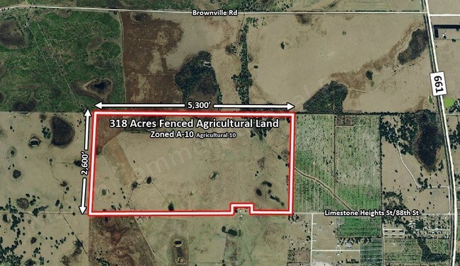
Pasture
DeSoto
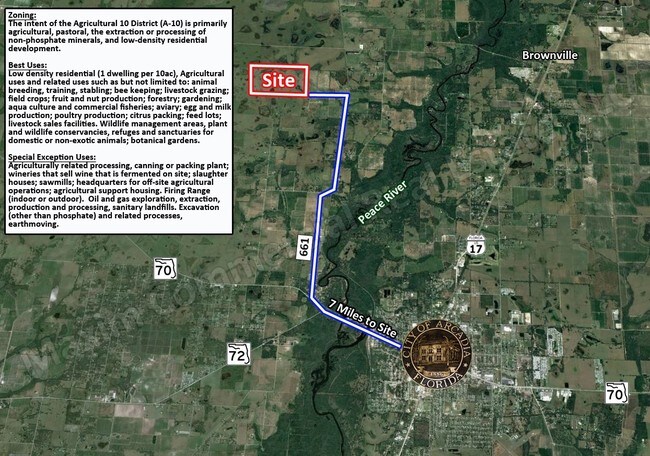
A
Florida
12027C0042C
158 AC
2024
Florida Central South Area
2024
Other Market Areas
010302
Arcadia, FL
DEMOGRAPHICS near Nw Limestone Heights St
1 mile
3 mile
5 mile
2024 Total Population
67
627
3,719
2029 Population
72
673
3,997
Pop Growth 2024-2029
+ 7.46%
+ 7.34%
+ 7.48%
Average Age
40
40
44
2024 Total Households
19
182
1,361
HH Growth 2024-2029
+ 10.53%
+ 7.69%
+ 8.16%
Median Household Inc
$21,875
$22,697
$35,951
Avg Household Size
2.60
2.70
2.50
2024 Avg HH Vehicles
1.00
1.00
2.00
Median Home Value
$162,499
$156,756
$129,848
Median Year Built
1985
1986
1993
Nearby Places
Map Layers
Map Styles
 Street
 Aerial
Transit
 Traffic
 Biking
Places
Listings with unknown addresses are not visible on the map
- Restaurants
- Banks
- Shops
- Fitness
- Groceries
PUBLIC TRANSPORTATION
AIRPORT
Punta Gorda
Drive
Walk
Distance
Punta Gorda
52 min
32.4 mi
Freight Ports
Port Manatee
Drive
Walk
Distance
Port Manatee
86 min
60.7 mi
SALE & LEASE HISTORY
LISTING DATE
SALE/LEASE

Oct 11, 2016
For Sale
Dec 02, 2016
For Sale
Nearby Properties
Address
Land Use
TOTAL SIZE
Lot Size
Zoning
Address
Land Use
TOTAL SIZE
Lot Size
Zoning
23,212 SF
6.56 AC
RMF-M
Address
Land Use
TOTAL SIZE
Lot Size
Zoning
12,528 SF
159 AC
A-10
Address
Land Use
TOTAL SIZE
Lot Size
Zoning
9,872 SF
1.95 AC
A-10
Address
Land Use
TOTAL SIZE
Lot Size
Zoning
2,817 SF
110.76 AC
A-10
Address
Land Use
TOTAL SIZE
Lot Size
Zoning
6,612 SF
10 AC
A-10
Address
Land Use
TOTAL SIZE
Lot Size
Zoning
5,376 SF
436.77 AC
A-10
Address
Land Use
TOTAL SIZE
Lot Size
Zoning
2,825 SF
314.74 AC
A-10
Address
Land Use
TOTAL SIZE
Lot Size
Zoning
3,017 SF
47.16 AC
A-10
Address
Land Use
TOTAL SIZE
Lot Size
Zoning
4,818 SF
17.76 AC
A-10
Address
Land Use
TOTAL SIZE
Lot Size
Zoning
3,784 SF
10 AC
A-10
Address
Land Use
TOTAL SIZE
Lot Size
Zoning
72.89 AC
A-10
Address
Land Use
TOTAL SIZE
Lot Size
Zoning
3,390 SF
10 AC
A-10
Address
Land Use
TOTAL SIZE
Lot Size
Zoning
3,520 SF
5 AC
A-10
Address
Land Use
TOTAL SIZE
Lot Size
Zoning
51.22 AC
A-10
Address
Land Use
TOTAL SIZE
Lot Size
Zoning
3,188 SF
40 AC
A-10
Address
Land Use
TOTAL SIZE
Lot Size
Zoning
3,067 SF
5.89 AC
A-10
Address
Land Use
TOTAL SIZE
Lot Size
Zoning
351.93 AC
A-10
Address
Land Use
TOTAL SIZE
Lot Size
Zoning
984 SF
133.36 AC
A-10
Address
Land Use
TOTAL SIZE
Lot Size
Zoning
3,284 SF
722 AC
A-10
Address
Land Use
TOTAL SIZE
Lot Size
Zoning
2,588 SF
5 AC
A-10
Address
Land Use
TOTAL SIZE
Lot Size
Zoning
4,736 SF
3.33 AC
RM
Address
Land Use
TOTAL SIZE
Lot Size
Zoning
4,546 SF
42.56 AC
A-10
Address
Land Use
TOTAL SIZE
Lot Size
Zoning
5,860 SF
10.44 AC
A-10
Address
Land Use
TOTAL SIZE
Lot Size
Zoning
1,566 SF
10.07 AC
A-10
Address
Land Use
TOTAL SIZE
Lot Size
Zoning
4,660 SF
19.22 AC
A-10
Address
Land Use
TOTAL SIZE
Lot Size
Zoning
2,403 SF
5.10 AC
A-10
Address
Land Use
TOTAL SIZE
Lot Size
Zoning
2,723 SF
5 AC
A-10
Address
Land Use
TOTAL SIZE
Lot Size
Zoning
2,824 SF
190 AC
A-10
Address
Land Use
TOTAL SIZE
Lot Size
Zoning
1,154 SF
5.14 AC
A-10
Address
Land Use
TOTAL SIZE
Lot Size
Zoning
1,104 SF
5 AC
A-10
The World's #1 Commercial Real Estate Marketplace
Connect with us
© 2026 CoStar Group
The information above has been obtained from sources believed reliable. While we do not doubt its accuracy we have not verified it and make no guarantee, warranty or representation about it. It is your responsibility to independently confirm its accuracy and completeness. Any projections, opinions, assumptions, or estimates used are for example only and do not represent the current or future performance of the property. The value of this transaction to you depends on tax and other factors which should be evaluated by your tax, financial, and legal advisors. You and your advisors should conduct a careful, independent investigation of the property to determine to your satisfaction the suitability of the property for your needs.