Property Record
7767 Archibald Ave, Eastvale, CA 92880
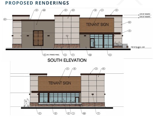

Current Lease Availabilities
NEARBY LISTINGS FOR SALE OR LEASE
Property Detail
7767 Archibald Ave
Riverside-San Bernardino-Ontario, CA
Parcel Map No 9292
144-130-011
Riverside
Sfr
California
X
0.85 AC
06065C0679H
Corona/Eastvale
1,366 SF
Inland Empire (California)
DEMOGRAPHICS near 7767 Archibald Ave
1 Mile
3 Mile
5 Mile
2024 Total Population
20,047
103,055
198,541
2029 Population
20,531
105,706
203,209
Pop Growth 2024-2029
+ 2.41%
+ 2.57%
+ 2.35%
Average Age
36
36
37
2024 Total Households
4,989
25,925
52,989
HH Growth 2024-2029
+ 2.08%
+ 2.35%
+ 2.03%
Median Household Inc
$174,063
$150,576
$130,171
Avg Household Size
3.90
3.60
3.50
2024 Avg HH Vehicles
3.00
3.00
3.00
Median Home Value
$766,923
$752,182
$742,399
Median Year Built
2007
2006
2002
Nearby Places
Map Layers
Map Styles
 Street
 Aerial
- Restaurants
- Banks
- Shops
- Fitness
- Groceries
PUBLIC TRANSPORTATION
COMMUTER RAIL
North Main Corona (91 Line - Southern California Regional Rail Authority (Metrolink), Inland Empire-Orange County Line - Southern California Regional Rail Authority (Metrolink))
DRIVE
WALK
Distance
North Main Corona (91 Line - Southern California Regional Rail Authority (Metrolink), Inland Empire-Orange County Line - Southern California Regional Rail Authority (Metrolink))
10 min
5.5 mi
West Corona (91 Line - Southern California Regional Rail Authority (Metrolink), Inland Empire-Orange County Line - Southern California Regional Rail Authority (Metrolink))
DRIVE
WALK
Distance
West Corona (91 Line - Southern California Regional Rail Authority (Metrolink), Inland Empire-Orange County Line - Southern California Regional Rail Authority (Metrolink))
13 min
6.7 mi
AIRPORT
Ontario International
DRIVE
WALK
Distance
Ontario International
14 min
7.8 mi
John Wayne/Orange County
DRIVE
WALK
Distance
John Wayne/Orange County
42 min
32.4 mi
Long Beach (Daugherty Field)
DRIVE
WALK
Distance
Long Beach (Daugherty Field)
59 min
46.9 mi
Freight Ports
Port of Long Beach
DRIVE
WALK
Distance
Port of Long Beach
65 min
46.5 mi
Nearby Properties
Address
Land Use
TOTAL SIZE
Lot Size
Zoning
Address
Land Use
TOTAL SIZE
Lot Size
Zoning
3,891,832 SF
67.79 AC
Address
Land Use
TOTAL SIZE
Lot Size
Zoning
1,225,320 SF
59.25 AC
Address
Land Use
TOTAL SIZE
Lot Size
Zoning
501,649 SF
21.61 AC
Address
Land Use
TOTAL SIZE
Lot Size
Zoning
1,240,128 SF
61.76 AC
Address
Land Use
TOTAL SIZE
Lot Size
Zoning
165,463 SF
17.43 AC
Address
Land Use
TOTAL SIZE
Lot Size
Zoning
488,330 SF
75.71 AC
Address
Land Use
TOTAL SIZE
Lot Size
Zoning
1,191,717 SF
53.86 AC
Address
Land Use
TOTAL SIZE
Lot Size
Zoning
674,696 SF
26.82 AC
Address
Land Use
TOTAL SIZE
Lot Size
Zoning
1,180,908 SF
47.62 AC
Address
Land Use
TOTAL SIZE
Lot Size
Zoning
286,192 SF
11.93 AC
Address
Land Use
TOTAL SIZE
Lot Size
Zoning
1,000,944 SF
47.56 AC
Address
Land Use
TOTAL SIZE
Lot Size
Zoning
700,280 SF
33.15 AC
Address
Land Use
TOTAL SIZE
Lot Size
Zoning
589,012 SF
30.87 AC
Address
Land Use
TOTAL SIZE
Lot Size
Zoning
364,193 SF
23.77 AC
Address
Land Use
TOTAL SIZE
Lot Size
Zoning
197,892 SF
9.28 AC
Address
Land Use
TOTAL SIZE
Lot Size
Zoning
725,160 SF
37 AC
Address
Land Use
TOTAL SIZE
Lot Size
Zoning
600,470 SF
30.64 AC
Address
Land Use
TOTAL SIZE
Lot Size
Zoning
161,120 SF
8 AC
Address
Land Use
TOTAL SIZE
Lot Size
Zoning
565,925 SF
29.35 AC
Address
Land Use
TOTAL SIZE
Lot Size
Zoning
505,735 SF
25.52 AC
Address
Land Use
TOTAL SIZE
Lot Size
Zoning
298,560 SF
9.51 AC
Address
Land Use
TOTAL SIZE
Lot Size
Zoning
958,800 SF
9.61 AC
Address
Land Use
TOTAL SIZE
Lot Size
Zoning
10.74 AC
Address
Land Use
TOTAL SIZE
Lot Size
Zoning
600,140 SF
30.62 AC
Address
Land Use
TOTAL SIZE
Lot Size
Zoning
448,255 SF
22.62 AC
Address
Land Use
TOTAL SIZE
Lot Size
Zoning
503,140 SF
25.69 AC
Address
Land Use
TOTAL SIZE
Lot Size
Zoning
154,581 SF
8.30 AC
Address
Land Use
TOTAL SIZE
Lot Size
Zoning
349,000 SF
15.05 AC
Address
Land Use
TOTAL SIZE
Lot Size
Zoning
160,264 SF
9.21 AC
M1
The World's #1 Commercial Real Estate Marketplace
Connect with us
© 2026 CoStar Group
The information above has been obtained from sources believed reliable. While we do not doubt its accuracy we have not verified it and make no guarantee, warranty or representation about it. It is your responsibility to independently confirm its accuracy and completeness. Any projections, opinions, assumptions, or estimates used are for example only and do not represent the current or future performance of the property. The value of this transaction to you depends on tax and other factors which should be evaluated by your tax, financial, and legal advisors. You and your advisors should conduct a careful, independent investigation of the property to determine to your satisfaction the suitability of the property for your needs.