Property Record
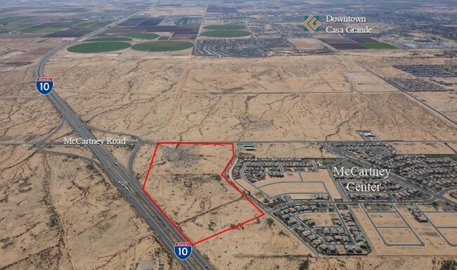
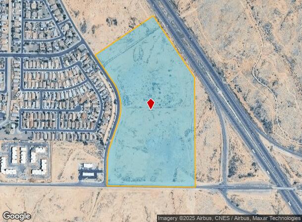
E Mccartney Rd, , AZ
NEARBY LISTINGS FOR SALE OR LEASE
-
-
-
-
-
SEC N Trekell Rd and E Rodeo Rd
Casa Grande, AZ 85122
$7,451,374 - $23,945,368
24.53 - 34.49 AC Lot
Land
-
-
-
View all listings for sale on LoopNet.com
Property Detail
E Mccartney Rd
Phoenix-Mesa-Scottsdale, AZ
Surveys
515-35-025A
BEG @ SE COR SEC 5-5S-6E TH N-1499.35 TH N 34D W-1027.91 TH S 55D W-955 TH S 34D E-500 TH SLY CURVE DIST-449.79 TH CONT ALONG CURV E DIST-107.97 TH S 19D W-306.17 TH SLY CURVE DIST-256.82 TH S-310 TH E-1175 TO POB AKA COMMERICAL PCLS D, E & F BK 17 O
Vacantlandnec
Pinal
X
Arizona
04021C1200E
52.71 AC
2024
Pinal County
2025
Phoenix
000000
DEMOGRAPHICS near E Mccartney Rd
1 Mile
3 Mile
5 Mile
2024 Total Population
1,556
21,451
63,470
2029 Population
2,016
27,404
80,475
Pop Growth 2024-2029
+ 29.56%
+ 27.75%
+ 26.79%
Average Age
37
39
40
2024 Total Households
480
7,337
22,990
HH Growth 2024-2029
+ 29.58%
+ 27.49%
+ 26.29%
Median Household Inc
$89,945
$75,922
$65,764
Avg Household Size
3.10
2.80
2.70
2024 Avg HH Vehicles
2.00
2.00
2.00
Median Home Value
$384,905
$323,389
$259,065
Median Year Built
2008
2005
2001
Nearby Places
Map Layers
Map Styles
 Street
 Aerial
- Restaurants
- Banks
- Shops
- Fitness
- Groceries
PUBLIC TRANSPORTATION
AIRPORT
Phoenix-Mesa Gateway
DRIVE
WALK
Distance
Phoenix-Mesa Gateway
54 min
38.8 mi
Freight Ports
Port of San Diego
DRIVE
WALK
Distance
Port of San Diego
381 min
357.5 mi
SALE & LEASE HISTORY
LISTING DATE
SALE/LEASE

Sep 24, 2016
For Sale
Sep 19, 2022
For Sale
Oct 23, 2018
For Lease
Oct 23, 2018
For Sale
Oct 09, 2017
For Sale
May 16, 2017
For Lease
Nearby Properties
Address
Land Use
TOTAL SIZE
Lot Size
Zoning
Address
Land Use
TOTAL SIZE
Lot Size
Zoning
289,599 SF
65.03 AC
Address
Land Use
TOTAL SIZE
Lot Size
Zoning
55,295 SF
12.14 AC
Address
Land Use
TOTAL SIZE
Lot Size
Zoning
107,832 SF
11.50 AC
Address
Land Use
TOTAL SIZE
Lot Size
Zoning
49,634 SF
14.10 AC
Address
Land Use
TOTAL SIZE
Lot Size
Zoning
59.61 AC
UNDESIGNAT
Address
Land Use
TOTAL SIZE
Lot Size
Zoning
3.23 AC
UNDESIGNAT
Address
Land Use
TOTAL SIZE
Lot Size
Zoning
Address
Land Use
TOTAL SIZE
Lot Size
Zoning
160 AC
Address
Land Use
TOTAL SIZE
Lot Size
Zoning
21,475 SF
2.63 AC
Address
Land Use
TOTAL SIZE
Lot Size
Zoning
67,365 SF
4.78 AC
UNDESIGNAT
Address
Land Use
TOTAL SIZE
Lot Size
Zoning
206,509 SF
12.40 AC
Address
Land Use
TOTAL SIZE
Lot Size
Zoning
14,736 SF
2.04 AC
Address
Land Use
TOTAL SIZE
Lot Size
Zoning
28.29 AC
UNDESIGNAT
Address
Land Use
TOTAL SIZE
Lot Size
Zoning
50.60 AC
CR1A
Address
Land Use
TOTAL SIZE
Lot Size
Zoning
20,991 SF
0.82 AC
Address
Land Use
TOTAL SIZE
Lot Size
Zoning
45.05 AC
Address
Land Use
TOTAL SIZE
Lot Size
Zoning
59.45 AC
UNDESIGNAT
Address
Land Use
TOTAL SIZE
Lot Size
Zoning
40.76 AC
UNDESIGNAT
Address
Land Use
TOTAL SIZE
Lot Size
Zoning
14,252 SF
16 AC
Address
Land Use
TOTAL SIZE
Lot Size
Zoning
Address
Land Use
TOTAL SIZE
Lot Size
Zoning
14,100 SF
40 AC
GR
Address
Land Use
TOTAL SIZE
Lot Size
Zoning
163.16 AC
Address
Land Use
TOTAL SIZE
Lot Size
Zoning
33.58 AC
UNDESIGNAT
Address
Land Use
TOTAL SIZE
Lot Size
Zoning
35.68 AC
UNDESIGNAT
Address
Land Use
TOTAL SIZE
Lot Size
Zoning
12,231 SF
1.23 AC
UNDESIGNAT
Address
Land Use
TOTAL SIZE
Lot Size
Zoning
192.87 AC
GR
Address
Land Use
TOTAL SIZE
Lot Size
Zoning
29.92 AC
UNDESIGNAT
The World's #1 Commercial Real Estate Marketplace
Connect with us
© 2025 CoStar Group
The information above has been obtained from sources believed reliable. While we do not doubt its accuracy we have not verified it and make no guarantee, warranty or representation about it. It is your responsibility to independently confirm its accuracy and completeness. Any projections, opinions, assumptions, or estimates used are for example only and do not represent the current or future performance of the property. The value of this transaction to you depends on tax and other factors which should be evaluated by your tax, financial, and legal advisors. You and your advisors should conduct a careful, independent investigation of the property to determine to your satisfaction the suitability of the property for your needs.