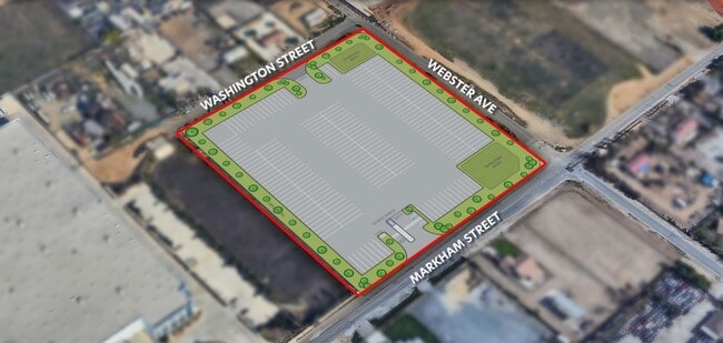
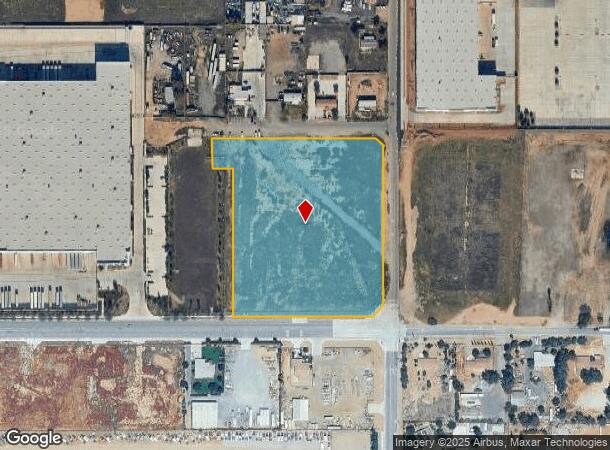
Property Record
850 W Markham St, Perris, CA 92571
Current Lease Availabilities
NEARBY LISTINGS FOR SALE OR LEASE
Property Detail
850 W Markham St
Riverside-San Bernardino-Ontario, CA
Parcel Map No 36678
314-160-001
6.78 ACRES NET IN PAR 2 PM 242/064 PM 36678
Commercialacreage
Riverside
D
California
06065C1430H
6.78 AC
2024
Moreno Valley/Perris
2025
Inland Empire (California)
042625
DEMOGRAPHICS near 850 W Markham St
1 mile
3 mile
5 mile
2024 Total Population
402
44,630
183,331
2029 Population
413
46,183
190,741
Pop Growth 2024-2029
+ 2.74%
+ 3.48%
+ 4.04%
Average Age
35
34
34
2024 Total Households
103
10,443
44,879
HH Growth 2024-2029
+ 1.94%
+ 2.82%
+ 3.46%
Median Household Inc
$112,500
$83,035
$76,227
Avg Household Size
3.60
4.00
3.90
2024 Avg HH Vehicles
3.00
3.00
3.00
Median Home Value
$420,000
$405,672
$389,642
Median Year Built
2001
1994
1990
Nearby Places
Map Layers
Map Styles
 Street
 Aerial
Transit
 Traffic
 Biking
Places
Listings with unknown addresses are not visible on the map
- Restaurants
- Banks
- Shops
- Fitness
- Groceries
PUBLIC TRANSPORTATION
COMMUTER RAIL
Perris Downtown (Metrolink 91-Perris Valley Line - Metrolink Trains)
Drive
Walk
Distance
Perris Downtown (Metrolink 91-Perris Valley Line - Metrolink Trains)
9 min
5.4 mi
Moreno Valley/March Field (Metrolink 91-Perris Valley Line - Metrolink Trains)
Drive
Walk
Distance
Moreno Valley/March Field (Metrolink 91-Perris Valley Line - Metrolink Trains)
9 min
5.6 mi
AIRPORT
Ontario International
Drive
Walk
Distance
Ontario International
38 min
29.7 mi
Freight Ports
Port of Long Beach
Drive
Walk
Distance
Port of Long Beach
88 min
64.4 mi
Nearby Properties
Address
Land Use
TOTAL SIZE
Lot Size
Zoning
Address
Land Use
TOTAL SIZE
Lot Size
Zoning
1,530,974 SF
71.21 AC
Address
Land Use
TOTAL SIZE
Lot Size
Zoning
1,851,898 SF
128.07 AC
Address
Land Use
TOTAL SIZE
Lot Size
Zoning
1,189,664 SF
55.26 AC
Address
Land Use
TOTAL SIZE
Lot Size
Zoning
1,224,874 SF
59.05 AC
Address
Land Use
TOTAL SIZE
Lot Size
Zoning
1,009,869 SF
46.76 AC
Address
Land Use
TOTAL SIZE
Lot Size
Zoning
783,407 SF
36.72 AC
Address
Land Use
TOTAL SIZE
Lot Size
Zoning
656,695 SF
30.75 AC
RA5
Address
Land Use
TOTAL SIZE
Lot Size
Zoning
1,138,800 SF
43.93 AC
Address
Land Use
TOTAL SIZE
Lot Size
Zoning
1,309,754 SF
57.79 AC
IL
Address
Land Use
TOTAL SIZE
Lot Size
Zoning
1,331,763 SF
62.60 AC
Address
Land Use
TOTAL SIZE
Lot Size
Zoning
579,708 SF
17.70 AC
LI
Address
Land Use
TOTAL SIZE
Lot Size
Zoning
343 SF
83.52 AC
LI
Address
Land Use
TOTAL SIZE
Lot Size
Zoning
678,087 SF
30.24 AC
Address
Land Use
TOTAL SIZE
Lot Size
Zoning
83.15 AC
Address
Land Use
TOTAL SIZE
Lot Size
Zoning
1,461,146 SF
72.62 AC
Address
Land Use
TOTAL SIZE
Lot Size
Zoning
436,350 SF
19.47 AC
Address
Land Use
TOTAL SIZE
Lot Size
Zoning
1,364,580 SF
80.02 AC
Address
Land Use
TOTAL SIZE
Lot Size
Zoning
692,465 SF
34.46 AC
Address
Land Use
TOTAL SIZE
Lot Size
Zoning
325,560 SF
16.65 AC
Address
Land Use
TOTAL SIZE
Lot Size
Zoning
695,786 SF
92.37 AC
Address
Land Use
TOTAL SIZE
Lot Size
Zoning
340,285 SF
14.39 AC
Address
Land Use
TOTAL SIZE
Lot Size
Zoning
1,297,200 SF
57.36 AC
Address
Land Use
TOTAL SIZE
Lot Size
Zoning
1,172,289 SF
41.82 AC
Address
Land Use
TOTAL SIZE
Lot Size
Zoning
348,375 SF
21.80 AC
Address
Land Use
TOTAL SIZE
Lot Size
Zoning
332,377 SF
21.12 AC
Address
Land Use
TOTAL SIZE
Lot Size
Zoning
1,582,985 SF
83.28 AC
LI
Address
Land Use
TOTAL SIZE
Lot Size
Zoning
285,482 SF
9.65 AC
Address
Land Use
TOTAL SIZE
Lot Size
Zoning
800,218 SF
37.43 AC
The World's #1 Commercial Real Estate Marketplace
Connect with us
© 2026 CoStar Group
The information above has been obtained from sources believed reliable. While we do not doubt its accuracy we have not verified it and make no guarantee, warranty or representation about it. It is your responsibility to independently confirm its accuracy and completeness. Any projections, opinions, assumptions, or estimates used are for example only and do not represent the current or future performance of the property. The value of this transaction to you depends on tax and other factors which should be evaluated by your tax, financial, and legal advisors. You and your advisors should conduct a careful, independent investigation of the property to determine to your satisfaction the suitability of the property for your needs.