Property Record
Unknown, , FL


Current Lease Availabilities
NEARBY LISTINGS FOR SALE OR LEASE
Property Detail
Unknown
Brevard County
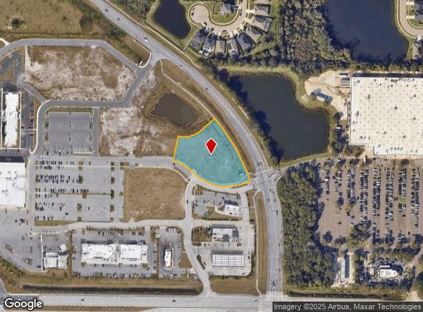
West Melbourne Interchange Center-Unit 4
Orlando
WEST MELBOURNE INTERCHANGE CENTER - UNIT FOUR, A REPLAT LOT 12
Palm Bay-Melbourne-Titusville, FL
Brevard
28-37-20-29-00000.0-0012.00
Florida
Commercialnec
12
2024
1.74 AC
2025
DEMOGRAPHICS near Unknown
1 Mile
3 Mile
5 Mile
2024 Total Population
11,287
82,062
164,776
2029 Population
12,834
89,343
180,576
Pop Growth 2024-2029
+ 13.71%
+ 8.87%
+ 9.59%
Average Age
42
43
43
2024 Total Households
5,107
34,004
66,203
HH Growth 2024-2029
+ 13.55%
+ 8.74%
+ 9.46%
Median Household Inc
$62,070
$58,875
$55,545
Avg Household Size
2.20
2.30
2.40
2024 Avg HH Vehicles
2.00
2.00
2.00
Median Home Value
$232,293
$235,178
$223,754
Median Year Built
2001
1989
1988
Nearby Places
- Restaurants
- Banks
- Shops
- Fitness
- Groceries
PUBLIC TRANSPORTATION
AIRPORT
Melbourne Orlando International
DRIVE
WALK
Distance
Melbourne Orlando International
15 min
5.7 mi
Freight Ports
Port Canaveral
DRIVE
WALK
Distance
Port Canaveral
48 min
39.2 mi
Nearby Properties
Address
Land Use
TOTAL SIZE
Lot Size
Zoning
Address
Land Use
TOTAL SIZE
Lot Size
Zoning
1,245,196 SF
110.73 AC
I1
Address
Land Use
TOTAL SIZE
Lot Size
Zoning
506,643 SF
80 AC
RA
Address
Land Use
TOTAL SIZE
Lot Size
Zoning
380,944 SF
32.18 AC
RA
Address
Land Use
TOTAL SIZE
Lot Size
Zoning
458,852 SF
23.05 AC
GU
Address
Land Use
TOTAL SIZE
Lot Size
Zoning
391,740 SF
30 AC
Address
Land Use
TOTAL SIZE
Lot Size
Zoning
582,248 SF
65.30 AC
RA
Address
Land Use
TOTAL SIZE
Lot Size
Zoning
292,165 SF
24.39 AC
RM15
Address
Land Use
TOTAL SIZE
Lot Size
Zoning
373,700 SF
12.96 AC
Address
Land Use
TOTAL SIZE
Lot Size
Zoning
368,326 SF
14.77 AC
C1
Address
Land Use
TOTAL SIZE
Lot Size
Zoning
387,843 SF
27.19 AC
R3
Address
Land Use
TOTAL SIZE
Lot Size
Zoning
393,147 SF
38.03 AC
RM20
Address
Land Use
TOTAL SIZE
Lot Size
Zoning
349,772 SF
16.27 AC
R2
Address
Land Use
TOTAL SIZE
Lot Size
Zoning
297,886 SF
32.38 AC
C-1
Address
Land Use
TOTAL SIZE
Lot Size
Zoning
268,487 SF
20.08 AC
RA
Address
Land Use
TOTAL SIZE
Lot Size
Zoning
257,044 SF
14.99 AC
Address
Land Use
TOTAL SIZE
Lot Size
Zoning
276,936 SF
18.44 AC
RM20
Address
Land Use
TOTAL SIZE
Lot Size
Zoning
542,262 SF
51.88 AC
CP
Address
Land Use
TOTAL SIZE
Lot Size
Zoning
201,017 SF
13.77 AC
RM20
Address
Land Use
TOTAL SIZE
Lot Size
Zoning
330,705 SF
25 AC
I1
Address
Land Use
TOTAL SIZE
Lot Size
Zoning
270,428 SF
19.69 AC
R2
Address
Land Use
TOTAL SIZE
Lot Size
Zoning
309,725 SF
14.70 AC
R2 (6)
Address
Land Use
TOTAL SIZE
Lot Size
Zoning
184,447 SF
14.06 AC
R2
Address
Land Use
TOTAL SIZE
Lot Size
Zoning
219,628 SF
29.84 AC
R2(6)
Address
Land Use
TOTAL SIZE
Lot Size
Zoning
203,448 SF
10.36 AC
C2
Address
Land Use
TOTAL SIZE
Lot Size
Zoning
139,968 SF
23.46 AC
CRA
Address
Land Use
TOTAL SIZE
Lot Size
Zoning
225,833 SF
14.45 AC
R2
Address
Land Use
TOTAL SIZE
Lot Size
Zoning
188,927 SF
17.97 AC
CP
Address
Land Use
TOTAL SIZE
Lot Size
Zoning
206,724 SF
11.74 AC
R3 (15)
Address
Land Use
TOTAL SIZE
Lot Size
Zoning
97,093 SF
20.87 AC
Address
Land Use
TOTAL SIZE
Lot Size
Zoning
205,308 SF
11.04 AC
RM20
The World's #1 Commercial Real Estate Marketplace
Connect with us
© 2025 CoStar Group
The information above has been obtained from sources believed reliable. While we do not doubt its accuracy we have not verified it and make no guarantee, warranty or representation about it. It is your responsibility to independently confirm its accuracy and completeness. Any projections, opinions, assumptions, or estimates used are for example only and do not represent the current or future performance of the property. The value of this transaction to you depends on tax and other factors which should be evaluated by your tax, financial, and legal advisors. You and your advisors should conduct a careful, independent investigation of the property to determine to your satisfaction the suitability of the property for your needs.