Property Record
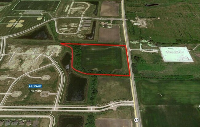
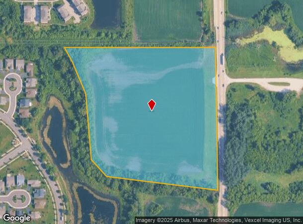
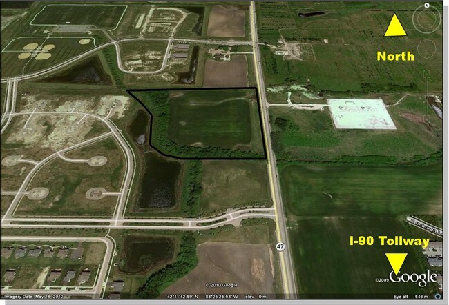
Il Route 47, Huntley, IL 60142
NEARBY LISTINGS FOR SALE OR LEASE
Property Detail
Il Route 47
Chicago-Naperville-Elgin, IL-IN-WI
Garliebn And Hardy Ujit Two Subdivsiion
18-21-100-019
DOC 2021R0040392 PT E PT N 837.7FT E1/2 NW1/4
Farms
McHenry
X
Illinois
17111C0308J
15.41 AC
2024
Far Northwest
2024
Chicago
871501
DEMOGRAPHICS near Il Route 47
1 Mile
3 Mile
5 Mile
2024 Total Population
6,289
38,007
87,747
2029 Population
6,366
38,078
87,794
Pop Growth 2024-2029
+ 1.22%
+ 0.19%
+ 0.05%
Average Age
35
37
42
2024 Total Households
1,913
12,105
31,869
HH Growth 2024-2029
+ 1.25%
+ 0.23%
+ 0.04%
Median Household Inc
$124,606
$118,689
$98,854
Avg Household Size
3.30
3.10
2.70
2024 Avg HH Vehicles
2.00
2.00
2.00
Median Home Value
$333,427
$287,144
$285,561
Median Year Built
2007
2001
1998
Nearby Places
Map Layers
Map Styles
 Street
 Aerial
- Restaurants
- Banks
- Shops
- Fitness
- Groceries
PUBLIC TRANSPORTATION
COMMUTER RAIL
Crystal Lake Station (Union Pacific Northwest Line - Northeast Illinois Regional Commuter Railroad (Metra))
DRIVE
WALK
Distance
Crystal Lake Station (Union Pacific Northwest Line - Northeast Illinois Regional Commuter Railroad (Metra))
15 min
9.1 mi
Freight Ports
Port Milwaukee
DRIVE
WALK
Distance
Port Milwaukee
107 min
76.3 mi
SALE & LEASE HISTORY
LISTING DATE
SALE/LEASE

Sep 24, 2016
For Sale
Mar 30, 2017
For Sale
Nearby Properties
Address
Land Use
TOTAL SIZE
Lot Size
Zoning
Address
Land Use
TOTAL SIZE
Lot Size
Zoning
7.26 AC
Address
Land Use
TOTAL SIZE
Lot Size
Zoning
11.86 AC
Address
Land Use
TOTAL SIZE
Lot Size
Zoning
3.50 AC
Address
Land Use
TOTAL SIZE
Lot Size
Zoning
Address
Land Use
TOTAL SIZE
Lot Size
Zoning
0.71 AC
Address
Land Use
TOTAL SIZE
Lot Size
Zoning
8.23 AC
Address
Land Use
TOTAL SIZE
Lot Size
Zoning
Address
Land Use
TOTAL SIZE
Lot Size
Zoning
92,850 SF
5 AC
Address
Land Use
TOTAL SIZE
Lot Size
Zoning
24,700 SF
3.08 AC
Address
Land Use
TOTAL SIZE
Lot Size
Zoning
85,500 SF
7 AC
Address
Land Use
TOTAL SIZE
Lot Size
Zoning
2.55 AC
Address
Land Use
TOTAL SIZE
Lot Size
Zoning
0.27 AC
Address
Land Use
TOTAL SIZE
Lot Size
Zoning
24,157 SF
1.97 AC
Address
Land Use
TOTAL SIZE
Lot Size
Zoning
71,064 SF
7 AC
Address
Land Use
TOTAL SIZE
Lot Size
Zoning
65,235 SF
4.74 AC
Address
Land Use
TOTAL SIZE
Lot Size
Zoning
48,150 SF
3.42 AC
Address
Land Use
TOTAL SIZE
Lot Size
Zoning
71,331 SF
8 AC
Address
Land Use
TOTAL SIZE
Lot Size
Zoning
Address
Land Use
TOTAL SIZE
Lot Size
Zoning
1.65 AC
Address
Land Use
TOTAL SIZE
Lot Size
Zoning
66,416 SF
3.04 AC
Address
Land Use
TOTAL SIZE
Lot Size
Zoning
45,000 SF
2.95 AC
Address
Land Use
TOTAL SIZE
Lot Size
Zoning
48,107 SF
2.21 AC
Address
Land Use
TOTAL SIZE
Lot Size
Zoning
8,934 SF
1.70 AC
Address
Land Use
TOTAL SIZE
Lot Size
Zoning
21,429 SF
1.31 AC
Address
Land Use
TOTAL SIZE
Lot Size
Zoning
35,100 SF
4.30 AC
Address
Land Use
TOTAL SIZE
Lot Size
Zoning
19,497 SF
3.52 AC
Address
Land Use
TOTAL SIZE
Lot Size
Zoning
16,082 SF
1.48 AC
Address
Land Use
TOTAL SIZE
Lot Size
Zoning
16,560 SF
2.07 AC
Address
Land Use
TOTAL SIZE
Lot Size
Zoning
17,666 SF
2.24 AC
The World's #1 Commercial Real Estate Marketplace
Connect with us
© 2025 CoStar Group
The information above has been obtained from sources believed reliable. While we do not doubt its accuracy we have not verified it and make no guarantee, warranty or representation about it. It is your responsibility to independently confirm its accuracy and completeness. Any projections, opinions, assumptions, or estimates used are for example only and do not represent the current or future performance of the property. The value of this transaction to you depends on tax and other factors which should be evaluated by your tax, financial, and legal advisors. You and your advisors should conduct a careful, independent investigation of the property to determine to your satisfaction the suitability of the property for your needs.