Property Record
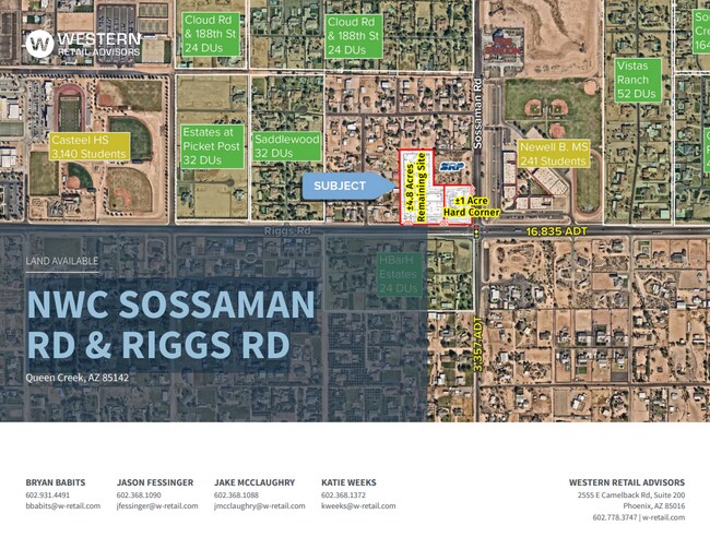
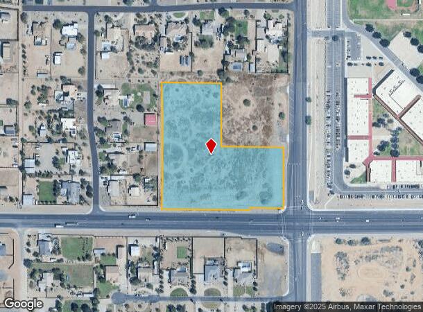
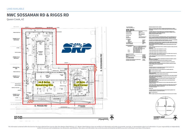
19126 E Riggs Rd, Queen Creek, AZ 85142
Current Lease Availabilities
NEARBY LISTINGS FOR SALE OR LEASE
Property Detail
19126 E Riggs Rd
304-90-438E
SE4 SE4 SE4 SEC 30 EX N 300F OF E 380F P/F 07-0949448 & EX S 80F RD EX ANY PT LY WI-IN N 10F S 80F W 415.23F TH/OF P/F 86-0674070 & P/F 16-0774263 & EX E 85F RD EX ANY PT LY WI-IN N 300F SD SE4 TH/OF P/F 16-0774263 & RM 7-44
Residentialacreage
Maricopa
X
Arizona
04013C3135L
5.80 AC
2025
Gateway Airport/Loop 202
2025
Phoenix
817200
Phoenix-Mesa-Scottsdale, AZ
DEMOGRAPHICS near 19126 E Riggs Rd
1 Mile
3 Mile
5 Mile
2024 Total Population
3,585
44,555
144,338
2029 Population
3,892
48,832
161,432
Pop Growth 2024-2029
+ 8.56%
+ 9.60%
+ 11.84%
Average Age
38
39
36
2024 Total Households
1,043
13,555
43,443
HH Growth 2024-2029
+ 8.53%
+ 9.40%
+ 11.88%
Median Household Inc
$121,913
$120,742
$118,524
Avg Household Size
3.40
3.20
3.30
2024 Avg HH Vehicles
3.00
2.00
2.00
Median Home Value
$642,979
$545,892
$468,145
Median Year Built
1997
2006
2009
Nearby Places
Map Layers
Map Styles
 Street
 Aerial
- Restaurants
- Banks
- Shops
- Fitness
- Groceries
PUBLIC TRANSPORTATION
AIRPORT
Phoenix-Mesa Gateway
DRIVE
WALK
Distance
Phoenix-Mesa Gateway
11 min
6.2 mi
Phoenix Sky Harbor International
DRIVE
WALK
Distance
Phoenix Sky Harbor International
48 min
32.9 mi
Freight Ports
Port of San Diego
DRIVE
WALK
Distance
Port of San Diego
409 min
370.6 mi
Nearby Properties
Address
Land Use
TOTAL SIZE
Lot Size
Zoning
Address
Land Use
TOTAL SIZE
Lot Size
Zoning
23,766 SF
29.45 AC
R-43
Address
Land Use
TOTAL SIZE
Lot Size
Zoning
32,858 SF
13.76 AC
C-G
Address
Land Use
TOTAL SIZE
Lot Size
Zoning
54,689 SF
5.41 AC
R-43
Address
Land Use
TOTAL SIZE
Lot Size
Zoning
53,995 SF
10.12 AC
Address
Land Use
TOTAL SIZE
Lot Size
Zoning
250,050 SF
17.47 AC
Address
Land Use
TOTAL SIZE
Lot Size
Zoning
339,494 SF
48.27 AC
R-4
Address
Land Use
TOTAL SIZE
Lot Size
Zoning
30,624 SF
13.41 AC
Address
Land Use
TOTAL SIZE
Lot Size
Zoning
30,944 SF
7.03 AC
Address
Land Use
TOTAL SIZE
Lot Size
Zoning
20,053 SF
3.86 AC
R-43
Address
Land Use
TOTAL SIZE
Lot Size
Zoning
139,348 SF
16.39 AC
R-12
Address
Land Use
TOTAL SIZE
Lot Size
Zoning
187,208 SF
34.75 AC
MDR
Address
Land Use
TOTAL SIZE
Lot Size
Zoning
6.02 AC
I-1
Address
Land Use
TOTAL SIZE
Lot Size
Zoning
270,126 SF
12.65 AC
C-TC
Address
Land Use
TOTAL SIZE
Lot Size
Zoning
103,423 SF
27.10 AC
PF
Address
Land Use
TOTAL SIZE
Lot Size
Zoning
117,552 SF
30.35 AC
R143
Address
Land Use
TOTAL SIZE
Lot Size
Zoning
92,160 SF
14.95 AC
PF
Address
Land Use
TOTAL SIZE
Lot Size
Zoning
95,413 SF
11.30 AC
R-43
Address
Land Use
TOTAL SIZE
Lot Size
Zoning
100,758 SF
12.30 AC
R-7
Address
Land Use
TOTAL SIZE
Lot Size
Zoning
179,893 SF
15 AC
C-G
Address
Land Use
TOTAL SIZE
Lot Size
Zoning
61,641 SF
39.91 AC
PF
Address
Land Use
TOTAL SIZE
Lot Size
Zoning
112,277 SF
9.68 AC
C-TC
Address
Land Use
TOTAL SIZE
Lot Size
Zoning
101,394 SF
8.70 AC
MDR
Address
Land Use
TOTAL SIZE
Lot Size
Zoning
69,001 SF
16.70 AC
DC
Address
Land Use
TOTAL SIZE
Lot Size
Zoning
3.34 AC
I-1
Address
Land Use
TOTAL SIZE
Lot Size
Zoning
119,569 SF
11.13 AC
C-G
Address
Land Use
TOTAL SIZE
Lot Size
Zoning
182,360 SF
10.52 AC
M-H
Address
Land Use
TOTAL SIZE
Lot Size
Zoning
2.16 AC
C-G
Address
Land Use
TOTAL SIZE
Lot Size
Zoning
125,933 SF
7.92 AC
C-G
Address
Land Use
TOTAL SIZE
Lot Size
Zoning
11,691 SF
3.61 AC
Address
Land Use
TOTAL SIZE
Lot Size
Zoning
58,874 SF
13.78 AC
R-43
The World's #1 Commercial Real Estate Marketplace
Connect with us
© 2025 CoStar Group
The information above has been obtained from sources believed reliable. While we do not doubt its accuracy we have not verified it and make no guarantee, warranty or representation about it. It is your responsibility to independently confirm its accuracy and completeness. Any projections, opinions, assumptions, or estimates used are for example only and do not represent the current or future performance of the property. The value of this transaction to you depends on tax and other factors which should be evaluated by your tax, financial, and legal advisors. You and your advisors should conduct a careful, independent investigation of the property to determine to your satisfaction the suitability of the property for your needs.