Property Record
Nwk Jersey City Tpke, Kearny, NJ 07032
NEARBY LISTINGS FOR SALE OR LEASE
Property Detail
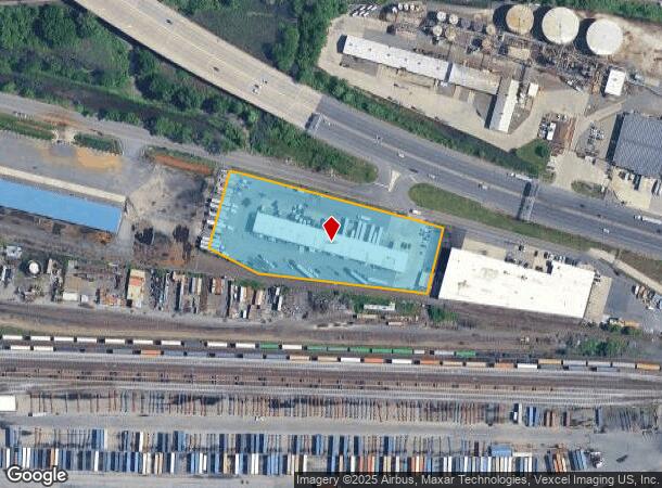
Nwk Jersey City Tpke
07-00284-0000-00021-05-HM
Hudson
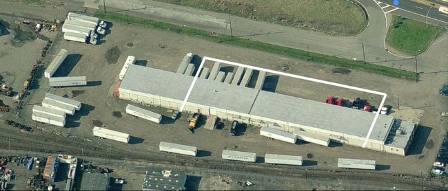
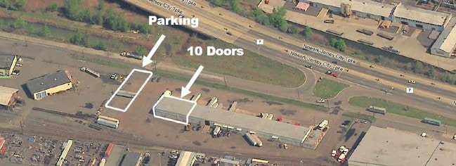
Warehouse
New Jersey
AE
21.5
34003C0331H
3.54 AC
2024
Lyndhurst/Harrison
2025
Northern New Jersey
012700
New York-Jersey City-White Plains, NY-NJ
21,620 SF
DEMOGRAPHICS near Nwk Jersey City Tpke
1 Mile
3 Mile
5 Mile
2024 Total Population
1,665
266,734
893,874
2029 Population
1,568
256,187
858,181
Pop Growth 2024-2029
(5.83%)
(3.95%)
(3.99%)
Average Age
33
37
38
2024 Total Households
471
104,255
373,882
HH Growth 2024-2029
(7.01%)
(4.25%)
(4.28%)
Median Household Inc
$39,226
$74,119
$86,734
Avg Household Size
2.90
2.40
2.30
2024 Avg HH Vehicles
1.00
1.00
1.00
Median Home Value
$690,217
$480,281
$566,517
Median Year Built
2002
1961
1964
Nearby Places
Map Layers
Map Styles
 Street
 Aerial
- Restaurants
- Banks
- Shops
- Fitness
- Groceries
PUBLIC TRANSPORTATION
COMMUTER RAIL
Journal Square (Journal Square-33rd Street - Port Authority Trans-Hudson (PATH), Newark Penn Station-World Trade Center - Port Authority Trans-Hudson (PATH))
DRIVE
WALK
Distance
Journal Square (Journal Square-33rd Street - Port Authority Trans-Hudson (PATH), Newark Penn Station-World Trade Center - Port Authority Trans-Hudson (PATH))
5 min
2.0 mi
Grove Street (Journal Square-33rd Street - Port Authority Trans-Hudson (PATH), Newark Penn Station-World Trade Center - Port Authority Trans-Hudson (PATH))
DRIVE
WALK
Distance
Grove Street (Journal Square-33rd Street - Port Authority Trans-Hudson (PATH), Newark Penn Station-World Trade Center - Port Authority Trans-Hudson (PATH))
7 min
3.4 mi
AIRPORT
Newark Liberty International
DRIVE
WALK
Distance
Newark Liberty International
14 min
8.6 mi
LaGuardia
DRIVE
WALK
Distance
LaGuardia
33 min
15.4 mi
John F Kennedy International
DRIVE
WALK
Distance
John F Kennedy International
45 min
23.6 mi
Freight Ports
Maher Terminal
DRIVE
WALK
Distance
Maher Terminal
18 min
8.2 mi
Nearby Properties
Address
Land Use
TOTAL SIZE
Lot Size
Zoning
Address
Land Use
TOTAL SIZE
Lot Size
Zoning
9.33 AC
C-1
Address
Land Use
TOTAL SIZE
Lot Size
Zoning
25.69 AC
Address
Land Use
TOTAL SIZE
Lot Size
Zoning
1.71 AC
C-1
Address
Land Use
TOTAL SIZE
Lot Size
Zoning
4.51 AC
Address
Land Use
TOTAL SIZE
Lot Size
Zoning
Address
Land Use
TOTAL SIZE
Lot Size
Zoning
1.15 AC
Address
Land Use
TOTAL SIZE
Lot Size
Zoning
Address
Land Use
TOTAL SIZE
Lot Size
Zoning
1.83 AC
I-2
Address
Land Use
TOTAL SIZE
Lot Size
Zoning
2,500 SF
43.35 AC
Address
Land Use
TOTAL SIZE
Lot Size
Zoning
9.28 AC
Address
Land Use
TOTAL SIZE
Lot Size
Zoning
Address
Land Use
TOTAL SIZE
Lot Size
Zoning
169.40 AC
Address
Land Use
TOTAL SIZE
Lot Size
Zoning
1.25 AC
I-2
Address
Land Use
TOTAL SIZE
Lot Size
Zoning
Address
Land Use
TOTAL SIZE
Lot Size
Zoning
0.33 AC
Address
Land Use
TOTAL SIZE
Lot Size
Zoning
1.71 AC
C-1
Address
Land Use
TOTAL SIZE
Lot Size
Zoning
0.51 AC
Address
Land Use
TOTAL SIZE
Lot Size
Zoning
3.18 AC
Address
Land Use
TOTAL SIZE
Lot Size
Zoning
Address
Land Use
TOTAL SIZE
Lot Size
Zoning
Address
Land Use
TOTAL SIZE
Lot Size
Zoning
Address
Land Use
TOTAL SIZE
Lot Size
Zoning
1.04 AC
Address
Land Use
TOTAL SIZE
Lot Size
Zoning
2.18 AC
C-2
Address
Land Use
TOTAL SIZE
Lot Size
Zoning
1.09 AC
I-2
Address
Land Use
TOTAL SIZE
Lot Size
Zoning
0.95 AC
Address
Land Use
TOTAL SIZE
Lot Size
Zoning
Address
Land Use
TOTAL SIZE
Lot Size
Zoning
12.67 AC
Address
Land Use
TOTAL SIZE
Lot Size
Zoning
5.64 AC
C-2
Address
Land Use
TOTAL SIZE
Lot Size
Zoning
108.75 AC
Address
Land Use
TOTAL SIZE
Lot Size
Zoning
710 SF
39.32 AC
The World's #1 Commercial Real Estate Marketplace
Connect with us
© 2025 CoStar Group
The information above has been obtained from sources believed reliable. While we do not doubt its accuracy we have not verified it and make no guarantee, warranty or representation about it. It is your responsibility to independently confirm its accuracy and completeness. Any projections, opinions, assumptions, or estimates used are for example only and do not represent the current or future performance of the property. The value of this transaction to you depends on tax and other factors which should be evaluated by your tax, financial, and legal advisors. You and your advisors should conduct a careful, independent investigation of the property to determine to your satisfaction the suitability of the property for your needs.