Property Record
S Waterleaf Dr, Westfield, IN 46074
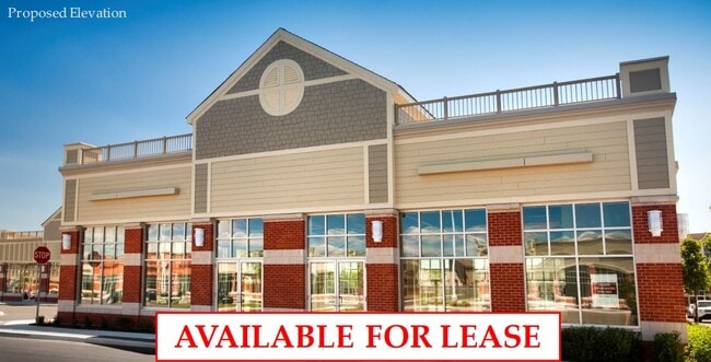
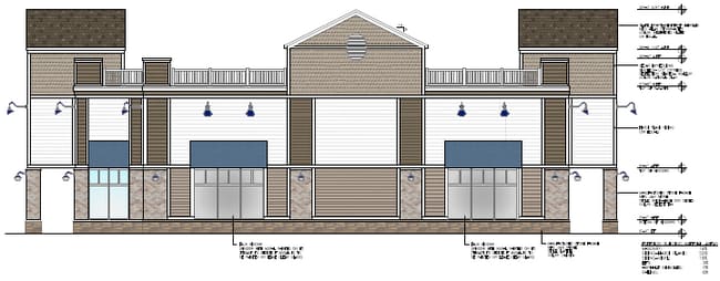
Current Lease Availabilities
NEARBY LISTINGS FOR SALE OR LEASE
Property Detail
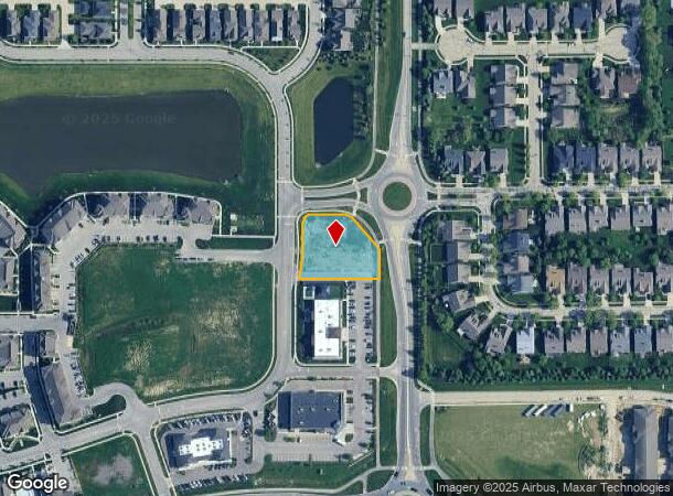
S Waterleaf Dr
Indianapolis-Carmel-Anderson, IN
Harmony Mixed Use District
29-09-16-005-002.001-015
ACREAGE .76, SECTION 16, TOWNSHIP 18, RANGE 3, HARMONY MIXED USE DISTRICT, REPLAT INFORMATION: LOT 2, LOT 2B, IRREGULAR SHAPE
Commercialacreage
Hamilton
X
Indiana
18057C0120G
2
2023
0.76 AC
2024
Carmel
110301
Indianapolis
DEMOGRAPHICS near S Waterleaf Dr
1 Mile
3 Mile
5 Mile
2024 Total Population
10,099
62,596
129,698
2029 Population
11,624
70,793
146,874
Pop Growth 2024-2029
+ 15.10%
+ 13.10%
+ 13.24%
Average Age
39
38
39
2024 Total Households
3,377
22,518
48,430
HH Growth 2024-2029
+ 15.37%
+ 13.21%
+ 13.33%
Median Household Inc
$151,445
$123,607
$113,659
Avg Household Size
2.90
2.70
2.60
2024 Avg HH Vehicles
2.00
2.00
2.00
Median Home Value
$419,826
$387,164
$395,799
Median Year Built
2006
2005
2002
Nearby Places
- Restaurants
- Banks
- Shops
- Fitness
- Groceries
PUBLIC TRANSPORTATION
AIRPORT
Indianapolis International
DRIVE
WALK
Distance
Indianapolis International
53 min
30.2 mi
Freight Ports
Port of Toledo
DRIVE
WALK
Distance
Port of Toledo
264 min
217.9 mi
Nearby Properties
Address
Land Use
TOTAL SIZE
Lot Size
Zoning
Address
Land Use
TOTAL SIZE
Lot Size
Zoning
435,973 SF
Address
Land Use
TOTAL SIZE
Lot Size
Zoning
342,574 SF
5.64 AC
Address
Land Use
TOTAL SIZE
Lot Size
Zoning
504,699 SF
40 AC
Address
Land Use
TOTAL SIZE
Lot Size
Zoning
383,016 SF
16.62 AC
Address
Land Use
TOTAL SIZE
Lot Size
Zoning
412,120 SF
12.16 AC
Address
Land Use
TOTAL SIZE
Lot Size
Zoning
393,106 SF
13.37 AC
Address
Land Use
TOTAL SIZE
Lot Size
Zoning
236,320 SF
20.74 AC
Address
Land Use
TOTAL SIZE
Lot Size
Zoning
280,428 SF
12.81 AC
Address
Land Use
TOTAL SIZE
Lot Size
Zoning
388,202 SF
23.97 AC
Address
Land Use
TOTAL SIZE
Lot Size
Zoning
261,335 SF
4.28 AC
Address
Land Use
TOTAL SIZE
Lot Size
Zoning
402,521 SF
153.38 AC
Address
Land Use
TOTAL SIZE
Lot Size
Zoning
245,922 SF
19.03 AC
Address
Land Use
TOTAL SIZE
Lot Size
Zoning
331,800 SF
1.54 AC
Address
Land Use
TOTAL SIZE
Lot Size
Zoning
257,957 SF
9.06 AC
Address
Land Use
TOTAL SIZE
Lot Size
Zoning
153,184 SF
1.17 AC
Address
Land Use
TOTAL SIZE
Lot Size
Zoning
210,424 SF
14.10 AC
Address
Land Use
TOTAL SIZE
Lot Size
Zoning
188,239 SF
11.15 AC
Address
Land Use
TOTAL SIZE
Lot Size
Zoning
228,713 SF
7.06 AC
Address
Land Use
TOTAL SIZE
Lot Size
Zoning
351,756 SF
8.38 AC
Address
Land Use
TOTAL SIZE
Lot Size
Zoning
212,140 SF
5.47 AC
Address
Land Use
TOTAL SIZE
Lot Size
Zoning
96,054 SF
9.88 AC
Address
Land Use
TOTAL SIZE
Lot Size
Zoning
101,294 SF
1.44 AC
Address
Land Use
TOTAL SIZE
Lot Size
Zoning
145,444 SF
34.32 AC
Address
Land Use
TOTAL SIZE
Lot Size
Zoning
189,622 SF
7.43 AC
Address
Land Use
TOTAL SIZE
Lot Size
Zoning
141,255 SF
21.61 AC
Address
Land Use
TOTAL SIZE
Lot Size
Zoning
150,702 SF
4.76 AC
Address
Land Use
TOTAL SIZE
Lot Size
Zoning
192,344 SF
19.05 AC
Address
Land Use
TOTAL SIZE
Lot Size
Zoning
87,040 SF
24.23 AC
Address
Land Use
TOTAL SIZE
Lot Size
Zoning
128,546 SF
3.82 AC
Address
Land Use
TOTAL SIZE
Lot Size
Zoning
147,081 SF
56.70 AC
The World's #1 Commercial Real Estate Marketplace
Connect with us
© 2025 CoStar Group
The information above has been obtained from sources believed reliable. While we do not doubt its accuracy we have not verified it and make no guarantee, warranty or representation about it. It is your responsibility to independently confirm its accuracy and completeness. Any projections, opinions, assumptions, or estimates used are for example only and do not represent the current or future performance of the property. The value of this transaction to you depends on tax and other factors which should be evaluated by your tax, financial, and legal advisors. You and your advisors should conduct a careful, independent investigation of the property to determine to your satisfaction the suitability of the property for your needs.