Property Record
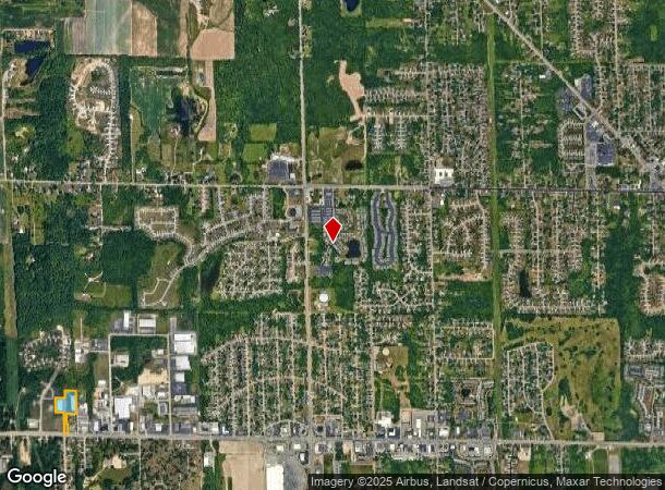
455 Lake Michigan Dr Nw, Grand Rapids, MI 49534
Current Lease Availabilities
NEARBY LISTINGS FOR SALE OR LEASE
Property Detail
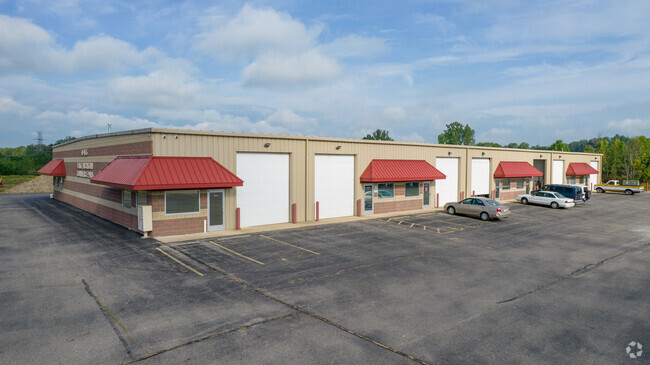
455 Lake Michigan Dr Nw
Grand Rapids-Wyoming, MI
Lake Michigan Commerce Park
70-10-24-397-000
GIS REF ONLY LAKE MICHIGAN COMMERCE PARK, UNITS 1 THRU 29, 397-001 THRU 397-029, AS RECORDED IN OTTAWA COUNTY REGISTER OF
Commercialacreage
Ottawa
X
Michigan
26081C0385D
4.75 AC
0
Northern Ottawa County
2025
West Michigan
011701
DEMOGRAPHICS near 455 Lake Michigan Dr Nw
1 Mile
3 Mile
5 Mile
2024 Total Population
3,620
25,584
74,309
2029 Population
3,859
26,354
76,232
Pop Growth 2024-2029
+ 6.60%
+ 3.01%
+ 2.59%
Average Age
38
40
38
2024 Total Households
1,288
10,439
28,013
HH Growth 2024-2029
+ 6.60%
+ 2.83%
+ 2.50%
Median Household Inc
$76,660
$73,357
$74,249
Avg Household Size
2.70
2.40
2.40
2024 Avg HH Vehicles
2.00
2.00
2.00
Median Home Value
$236,696
$258,126
$245,717
Median Year Built
1998
1987
1977
Nearby Places
Map Layers
Map Styles
 Street
 Aerial
- Restaurants
- Banks
- Shops
- Fitness
- Groceries
PUBLIC TRANSPORTATION
COMMUTER RAIL
Grand Rapids Vernon J. Ehlers Station (Pere Marquette - Amtrak)
DRIVE
WALK
Distance
Grand Rapids Vernon J. Ehlers Station (Pere Marquette - Amtrak)
13 min
6.8 mi
AIRPORT
Gerald R Ford International
DRIVE
WALK
Distance
Gerald R Ford International
33 min
21.1 mi
Freight Ports
Port Milwaukee
DRIVE
WALK
Distance
Port Milwaukee
304 min
260.8 mi
Nearby Properties
Address
Land Use
TOTAL SIZE
Lot Size
Zoning
Address
Land Use
TOTAL SIZE
Lot Size
Zoning
390,682 SF
47.73 AC
ARM - MULT
Address
Land Use
TOTAL SIZE
Lot Size
Zoning
389,181 SF
51.01 AC
RPUD - 2
Address
Land Use
TOTAL SIZE
Lot Size
Zoning
32.89 AC
TN-LDR
Address
Land Use
TOTAL SIZE
Lot Size
Zoning
455,639 SF
42.06 AC
MH
Address
Land Use
TOTAL SIZE
Lot Size
Zoning
340,744 SF
69.50 AC
RPUD - 2
Address
Land Use
TOTAL SIZE
Lot Size
Zoning
343,973 SF
29.15 AC
MON-LDR
Address
Land Use
TOTAL SIZE
Lot Size
Zoning
278,832 SF
NOT APP
Address
Land Use
TOTAL SIZE
Lot Size
Zoning
245,620 SF
20.13 AC
RPUD - 2
Address
Land Use
TOTAL SIZE
Lot Size
Zoning
410,206 SF
54.36 AC
MH
Address
Land Use
TOTAL SIZE
Lot Size
Zoning
162,765 SF
22.63 AC
MP
Address
Land Use
TOTAL SIZE
Lot Size
Zoning
209,522 SF
27.89 AC
CPUD
Address
Land Use
TOTAL SIZE
Lot Size
Zoning
147,232 SF
18.42 AC
ARM - MULT
Address
Land Use
TOTAL SIZE
Lot Size
Zoning
247,168 SF
9.60 AC
MP
Address
Land Use
TOTAL SIZE
Lot Size
Zoning
332,315 SF
17.71 AC
MP
Address
Land Use
TOTAL SIZE
Lot Size
Zoning
107,800 SF
13.29 AC
CPUD
Address
Land Use
TOTAL SIZE
Lot Size
Zoning
250,469 SF
14.11 AC
ML
Address
Land Use
TOTAL SIZE
Lot Size
Zoning
200,831 SF
11.69 AC
MH
Address
Land Use
TOTAL SIZE
Lot Size
Zoning
140,841 SF
8.96 AC
Address
Land Use
TOTAL SIZE
Lot Size
Zoning
197,220 SF
10.94 AC
MP
Address
Land Use
TOTAL SIZE
Lot Size
Zoning
222,833 SF
20.49 AC
MH
Address
Land Use
TOTAL SIZE
Lot Size
Zoning
85,472 SF
12.17 AC
ARM - MULT
Address
Land Use
TOTAL SIZE
Lot Size
Zoning
150,000 SF
19.41 AC
IPUD
Address
Land Use
TOTAL SIZE
Lot Size
Zoning
104,000 SF
NOT APP
Address
Land Use
TOTAL SIZE
Lot Size
Zoning
Address
Land Use
TOTAL SIZE
Lot Size
Zoning
141,672 SF
11.82 AC
MP
Address
Land Use
TOTAL SIZE
Lot Size
Zoning
78,872 SF
3.09 AC
MON-LDR
Address
Land Use
TOTAL SIZE
Lot Size
Zoning
200,000 SF
13.41 AC
MP
Address
Land Use
TOTAL SIZE
Lot Size
Zoning
65,491 SF
7.29 AC
MP
Address
Land Use
TOTAL SIZE
Lot Size
Zoning
195,000 SF
11.09 AC
MP
Address
Land Use
TOTAL SIZE
Lot Size
Zoning
88,113 SF
12.50 AC
The World's #1 Commercial Real Estate Marketplace
Connect with us
© 2025 CoStar Group
The information above has been obtained from sources believed reliable. While we do not doubt its accuracy we have not verified it and make no guarantee, warranty or representation about it. It is your responsibility to independently confirm its accuracy and completeness. Any projections, opinions, assumptions, or estimates used are for example only and do not represent the current or future performance of the property. The value of this transaction to you depends on tax and other factors which should be evaluated by your tax, financial, and legal advisors. You and your advisors should conduct a careful, independent investigation of the property to determine to your satisfaction the suitability of the property for your needs.