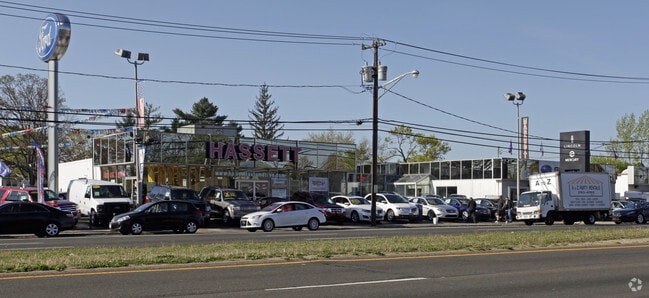
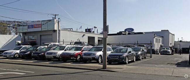
Property Record
Oakland Ave, Seaford, NY 11783

NEARBY LISTINGS FOR SALE OR LEASE
Property Detail
Oakland Ave
2089-57-103-00-0213-0
213,218
Autorepair
Nassau
X
New York
36059C0242G
213
2025
0.26 AC
2025
Southeast Nassau
522700
Long Island (New York)
11,000 SF
Nassau County-Suffolk County, NY
DEMOGRAPHICS near Oakland Ave
1 Mile
3 Mile
5 Mile
2024 Total Population
18,776
151,905
384,525
2029 Population
18,426
148,961
377,364
Pop Growth 2024-2029
(1.86%)
(1.94%)
(1.86%)
Average Age
42
42
42
2024 Total Households
6,265
50,586
124,587
HH Growth 2024-2029
(2.00%)
(2.09%)
(1.98%)
Median Household Inc
$152,582
$148,905
$130,206
Avg Household Size
2.90
2.90
3.00
2024 Avg HH Vehicles
2.00
2.00
2.00
Median Home Value
$675,422
$671,033
$603,621
Median Year Built
1954
1955
1955
Nearby Places
- Restaurants
- Banks
- Shops
- Fitness
- Groceries
PUBLIC TRANSPORTATION
COMMUTER RAIL
Wantagh Station (Babylon Branch - Long Island Rail Road)
DRIVE
WALK
Distance
Wantagh Station (Babylon Branch - Long Island Rail Road)
1 min
8 min
0.4 mi
Seaford Station (Babylon Branch - Long Island Rail Road)
DRIVE
WALK
Distance
Seaford Station (Babylon Branch - Long Island Rail Road)
2 min
1.1 mi
AIRPORT
John F Kennedy International
DRIVE
WALK
Distance
John F Kennedy International
26 min
17.8 mi
LaGuardia
DRIVE
WALK
Distance
LaGuardia
36 min
24.8 mi
Long Island MacArthur
DRIVE
WALK
Distance
Long Island MacArthur
35 min
25.4 mi
Freight Ports
NY - Red Hook Container Terminal
DRIVE
WALK
Distance
NY - Red Hook Container Terminal
47 min
29.2 mi
Nearby Properties
Address
Land Use
TOTAL SIZE
Lot Size
Zoning
Address
Land Use
TOTAL SIZE
Lot Size
Zoning
49,840 SF
729.60 AC
Address
Land Use
TOTAL SIZE
Lot Size
Zoning
163.85 AC
Address
Land Use
TOTAL SIZE
Lot Size
Zoning
20,080 SF
91.79 AC
Address
Land Use
TOTAL SIZE
Lot Size
Zoning
105,868 SF
198 AC
Address
Land Use
TOTAL SIZE
Lot Size
Zoning
4,356 SF
246.70 AC
Address
Land Use
TOTAL SIZE
Lot Size
Zoning
20,000 SF
123.34 AC
Address
Land Use
TOTAL SIZE
Lot Size
Zoning
147.58 AC
Address
Land Use
TOTAL SIZE
Lot Size
Zoning
Address
Land Use
TOTAL SIZE
Lot Size
Zoning
19.88 AC
Address
Land Use
TOTAL SIZE
Lot Size
Zoning
119,692 SF
24.59 AC
Address
Land Use
TOTAL SIZE
Lot Size
Zoning
249,762 SF
18.36 AC
Address
Land Use
TOTAL SIZE
Lot Size
Zoning
3,900 SF
52.04 AC
Address
Land Use
TOTAL SIZE
Lot Size
Zoning
57,874 SF
21 AC
Address
Land Use
TOTAL SIZE
Lot Size
Zoning
Address
Land Use
TOTAL SIZE
Lot Size
Zoning
9,515 SF
121.73 AC
Address
Land Use
TOTAL SIZE
Lot Size
Zoning
17,305 SF
51.61 AC
Address
Land Use
TOTAL SIZE
Lot Size
Zoning
10,072 SF
22.75 AC
Address
Land Use
TOTAL SIZE
Lot Size
Zoning
1,500 SF
125.69 AC
Address
Land Use
TOTAL SIZE
Lot Size
Zoning
67,408 SF
66.13 AC
Address
Land Use
TOTAL SIZE
Lot Size
Zoning
120,000 SF
28.96 AC
Address
Land Use
TOTAL SIZE
Lot Size
Zoning
80,895 SF
26.22 AC
Address
Land Use
TOTAL SIZE
Lot Size
Zoning
2,145 SF
52.37 AC
Address
Land Use
TOTAL SIZE
Lot Size
Zoning
86.38 AC
Address
Land Use
TOTAL SIZE
Lot Size
Zoning
1,181 SF
25.01 AC
Address
Land Use
TOTAL SIZE
Lot Size
Zoning
76,790 SF
19.32 AC
Address
Land Use
TOTAL SIZE
Lot Size
Zoning
253,201 SF
16.01 AC
Address
Land Use
TOTAL SIZE
Lot Size
Zoning
112,053 SF
16.13 AC
Address
Land Use
TOTAL SIZE
Lot Size
Zoning
65,102 SF
27.67 AC
Address
Land Use
TOTAL SIZE
Lot Size
Zoning
13,200 SF
9.44 AC
Address
Land Use
TOTAL SIZE
Lot Size
Zoning
28.33 AC
The World's #1 Commercial Real Estate Marketplace
Connect with us
© 2025 CoStar Group
The information above has been obtained from sources believed reliable. While we do not doubt its accuracy we have not verified it and make no guarantee, warranty or representation about it. It is your responsibility to independently confirm its accuracy and completeness. Any projections, opinions, assumptions, or estimates used are for example only and do not represent the current or future performance of the property. The value of this transaction to you depends on tax and other factors which should be evaluated by your tax, financial, and legal advisors. You and your advisors should conduct a careful, independent investigation of the property to determine to your satisfaction the suitability of the property for your needs.