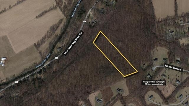
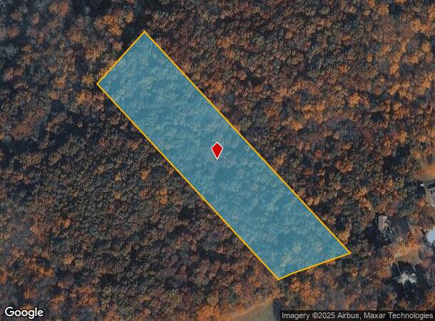
Property Record
Off Musconetcong River Rd, Lebanon, NJ 08833
NEARBY LISTINGS FOR SALE OR LEASE
-
-
View all Lebanon listings for sale on LoopNet.com
Property Detail
Off Musconetcong River Rd
19-00069-0000-00028
Hunterdon
Vacantlandnec
New Jersey
X
28
34041C0327E
8.50 AC
2024
Route 78 West
2025
Northern New Jersey
010802
Newark, NJ-PA
DEMOGRAPHICS near Off Musconetcong River Rd
1 Mile
3 Mile
5 Mile
2024 Total Population
852
14,525
28,812
2029 Population
868
14,712
29,270
Pop Growth 2024-2029
+ 1.88%
+ 1.29%
+ 1.59%
Average Age
45
43
44
2024 Total Households
320
5,868
11,109
HH Growth 2024-2029
+ 2.19%
+ 1.23%
+ 1.62%
Median Household Inc
$117,229
$89,737
$98,002
Avg Household Size
2.60
2.40
2.50
2024 Avg HH Vehicles
3.00
2.00
2.00
Median Home Value
$408,784
$318,679
$336,395
Median Year Built
1976
1970
1970
Nearby Places
Map Layers
Map Styles
 Street
 Aerial
- Restaurants
- Banks
- Shops
- Fitness
- Groceries
PUBLIC TRANSPORTATION
COMMUTER RAIL
High Bridge (Raritan Valley Line - NJ Transit Commuter Rail (NJ Transit))
DRIVE
WALK
Distance
High Bridge (Raritan Valley Line - NJ Transit Commuter Rail (NJ Transit))
15 min
7.8 mi
Annandale (Raritan Valley Line - NJ Transit Commuter Rail (NJ Transit))
DRIVE
WALK
Distance
Annandale (Raritan Valley Line - NJ Transit Commuter Rail (NJ Transit))
18 min
9.7 mi
AIRPORT
Lehigh Valley International
DRIVE
WALK
Distance
Lehigh Valley International
58 min
31.7 mi
Freight Ports
New York Container Terminal
DRIVE
WALK
Distance
New York Container Terminal
75 min
53.9 mi
SALE & LEASE HISTORY
LISTING DATE
SALE/LEASE

Sep 14, 2021
For Sale
Nearby Properties
Address
Land Use
TOTAL SIZE
Lot Size
Zoning
Address
Land Use
TOTAL SIZE
Lot Size
Zoning
52.10 AC
PCOS
Address
Land Use
TOTAL SIZE
Lot Size
Zoning
215.75 AC
RC
Address
Land Use
TOTAL SIZE
Lot Size
Zoning
Address
Land Use
TOTAL SIZE
Lot Size
Zoning
Address
Land Use
TOTAL SIZE
Lot Size
Zoning
22.84 AC
HC
Address
Land Use
TOTAL SIZE
Lot Size
Zoning
226,375 SF
50.41 AC
Address
Land Use
TOTAL SIZE
Lot Size
Zoning
20.43 AC
R4
Address
Land Use
TOTAL SIZE
Lot Size
Zoning
6.24 AC
PVD
Address
Land Use
TOTAL SIZE
Lot Size
Zoning
3.98 AC
B-4
Address
Land Use
TOTAL SIZE
Lot Size
Zoning
8.97 AC
Address
Land Use
TOTAL SIZE
Lot Size
Zoning
Address
Land Use
TOTAL SIZE
Lot Size
Zoning
Address
Land Use
TOTAL SIZE
Lot Size
Zoning
1,280 SF
240.85 AC
PVD
Address
Land Use
TOTAL SIZE
Lot Size
Zoning
1.87 AC
PVD
Address
Land Use
TOTAL SIZE
Lot Size
Zoning
5.40 AC
OR
Address
Land Use
TOTAL SIZE
Lot Size
Zoning
5.50 AC
OR
Address
Land Use
TOTAL SIZE
Lot Size
Zoning
5.08 AC
HC
Address
Land Use
TOTAL SIZE
Lot Size
Zoning
5,752 SF
2.09 AC
RA
Address
Land Use
TOTAL SIZE
Lot Size
Zoning
203 AC
MR
Address
Land Use
TOTAL SIZE
Lot Size
Zoning
4.89 AC
R4
Address
Land Use
TOTAL SIZE
Lot Size
Zoning
12,448 SF
2 AC
RC
Address
Land Use
TOTAL SIZE
Lot Size
Zoning
6.04 AC
HC
Address
Land Use
TOTAL SIZE
Lot Size
Zoning
1,520 SF
302.94 AC
RC
Address
Land Use
TOTAL SIZE
Lot Size
Zoning
38,415 SF
4 AC
Address
Land Use
TOTAL SIZE
Lot Size
Zoning
1.98 AC
PVD
Address
Land Use
TOTAL SIZE
Lot Size
Zoning
1.70 AC
HC
Address
Land Use
TOTAL SIZE
Lot Size
Zoning
7,500 SF
6.05 AC
HC
Address
Land Use
TOTAL SIZE
Lot Size
Zoning
2,010 SF
1.68 AC
B1
Address
Land Use
TOTAL SIZE
Lot Size
Zoning
5.52 AC
R4
Address
Land Use
TOTAL SIZE
Lot Size
Zoning
3 AC
B-2
The World's #1 Commercial Real Estate Marketplace
Connect with us
© 2025 CoStar Group
The information above has been obtained from sources believed reliable. While we do not doubt its accuracy we have not verified it and make no guarantee, warranty or representation about it. It is your responsibility to independently confirm its accuracy and completeness. Any projections, opinions, assumptions, or estimates used are for example only and do not represent the current or future performance of the property. The value of this transaction to you depends on tax and other factors which should be evaluated by your tax, financial, and legal advisors. You and your advisors should conduct a careful, independent investigation of the property to determine to your satisfaction the suitability of the property for your needs.