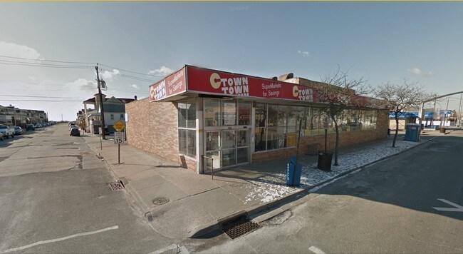
Property Record
Ohio Ave, Long Beach, NY 11561
NEARBY LISTINGS FOR SALE OR LEASE
Property Detail
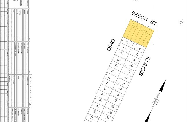
Ohio Ave
Nassau County-Suffolk County, NY
West End Long Beach
1000-58-116-00-0008-0
1-6
Storebuilding
Nassau
AE
New York
36059C0304G
1
2025
0.04 AC
2025
Southern Nassau
416401
Long Island (New York)
1,800 SF
DEMOGRAPHICS near Ohio Ave
1 Mile
3 Mile
5 Mile
2024 Total Population
9,416
78,721
235,954
2029 Population
9,254
76,444
228,010
Pop Growth 2024-2029
(1.72%)
(2.89%)
(3.37%)
Average Age
44
42
40
2024 Total Households
3,950
30,177
81,596
HH Growth 2024-2029
(1.87%)
(2.69%)
(3.34%)
Median Household Inc
$138,042
$96,469
$95,074
Avg Household Size
2.30
2.40
2.70
2024 Avg HH Vehicles
2.00
1.00
1.00
Median Home Value
$744,176
$747,399
$697,962
Median Year Built
1949
1959
1958
Nearby Places
- Restaurants
- Banks
- Shops
- Fitness
- Groceries
PUBLIC TRANSPORTATION
COMMUTER RAIL
Long Beach Station (Long Beach Branch - Long Island Rail Road)
DRIVE
WALK
Distance
Long Beach Station (Long Beach Branch - Long Island Rail Road)
4 min
2.1 mi
Island Park Station (Long Beach Branch - Long Island Rail Road)
DRIVE
WALK
Distance
Island Park Station (Long Beach Branch - Long Island Rail Road)
6 min
3.4 mi
AIRPORT
John F Kennedy International
DRIVE
WALK
Distance
John F Kennedy International
23 min
12.6 mi
LaGuardia
DRIVE
WALK
Distance
LaGuardia
32 min
18.3 mi
Newark Liberty International
DRIVE
WALK
Distance
Newark Liberty International
59 min
38.0 mi
Freight Ports
NY - Red Hook Container Terminal
DRIVE
WALK
Distance
NY - Red Hook Container Terminal
43 min
22.5 mi
Nearby Properties
Address
Land Use
TOTAL SIZE
Lot Size
Zoning
Address
Land Use
TOTAL SIZE
Lot Size
Zoning
52.80 AC
PARK
Address
Land Use
TOTAL SIZE
Lot Size
Zoning
188,656 SF
5.78 AC
R5
Address
Land Use
TOTAL SIZE
Lot Size
Zoning
119,788 SF
3.90 AC
R5
Address
Land Use
TOTAL SIZE
Lot Size
Zoning
6,077 SF
19.66 AC
PARK
Address
Land Use
TOTAL SIZE
Lot Size
Zoning
77,576 SF
1.38 AC
R5
Address
Land Use
TOTAL SIZE
Lot Size
Zoning
163,623 SF
2.94 AC
R5
Address
Land Use
TOTAL SIZE
Lot Size
Zoning
189,500 SF
2.87 AC
R6
Address
Land Use
TOTAL SIZE
Lot Size
Zoning
95,000 SF
2.31 AC
R4-1
Address
Land Use
TOTAL SIZE
Lot Size
Zoning
72,790 SF
1.09 AC
R5
Address
Land Use
TOTAL SIZE
Lot Size
Zoning
44,939 SF
0.78 AC
R5
Address
Land Use
TOTAL SIZE
Lot Size
Zoning
242,771 SF
3.24 AC
R5
Address
Land Use
TOTAL SIZE
Lot Size
Zoning
40,272 SF
2.13 AC
R5
Address
Land Use
TOTAL SIZE
Lot Size
Zoning
44,261 SF
0.64 AC
R4A
Address
Land Use
TOTAL SIZE
Lot Size
Zoning
68,735 SF
0.45 AC
R6
Address
Land Use
TOTAL SIZE
Lot Size
Zoning
57.65 AC
R6
Address
Land Use
TOTAL SIZE
Lot Size
Zoning
59,673 SF
0.88 AC
R4-1
Address
Land Use
TOTAL SIZE
Lot Size
Zoning
145,703 SF
1.31 AC
R6
Address
Land Use
TOTAL SIZE
Lot Size
Zoning
32,900 SF
0.57 AC
R4-1
Address
Land Use
TOTAL SIZE
Lot Size
Zoning
95,300 SF
1.46 AC
R5
Address
Land Use
TOTAL SIZE
Lot Size
Zoning
144,202 SF
1.51 AC
R6
Address
Land Use
TOTAL SIZE
Lot Size
Zoning
37,600 SF
0.80 AC
R2X
Address
Land Use
TOTAL SIZE
Lot Size
Zoning
10,938 SF
2.09 AC
R5
Address
Land Use
TOTAL SIZE
Lot Size
Zoning
81,500 SF
1.02 AC
R5
Address
Land Use
TOTAL SIZE
Lot Size
Zoning
65,874 SF
1.22 AC
R5
Address
Land Use
TOTAL SIZE
Lot Size
Zoning
42,750 SF
0.89 AC
R5
Address
Land Use
TOTAL SIZE
Lot Size
Zoning
61,433 SF
1.56 AC
R4A
Address
Land Use
TOTAL SIZE
Lot Size
Zoning
59,280 SF
0.23 AC
R6
Address
Land Use
TOTAL SIZE
Lot Size
Zoning
20,360 SF
1.73 AC
R4-1
Address
Land Use
TOTAL SIZE
Lot Size
Zoning
38,025 SF
0.41 AC
R5
Address
Land Use
TOTAL SIZE
Lot Size
Zoning
42,900 SF
0.52 AC
R5
The World's #1 Commercial Real Estate Marketplace
Connect with us
© 2025 CoStar Group
The information above has been obtained from sources believed reliable. While we do not doubt its accuracy we have not verified it and make no guarantee, warranty or representation about it. It is your responsibility to independently confirm its accuracy and completeness. Any projections, opinions, assumptions, or estimates used are for example only and do not represent the current or future performance of the property. The value of this transaction to you depends on tax and other factors which should be evaluated by your tax, financial, and legal advisors. You and your advisors should conduct a careful, independent investigation of the property to determine to your satisfaction the suitability of the property for your needs.