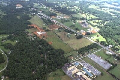
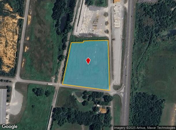
Property Record
Old 27 Hwy, Rock Spring, GA 30739
NEARBY LISTINGS FOR SALE OR LEASE
Property Detail
Old 27 Hwy
Chattanooga, TN-GA
Battlebluff
03273-052
PTLL 95 8/4 LOTS 1-5 MATHIS SURVEY
Governmentalpublicusegeneral
Walker
X
Georgia
13047C0130E
1-5
0
5.21 AC
2024
Walker County
020601
Chattanooga
DEMOGRAPHICS near Old 27 Hwy
1 Mile
3 Mile
5 Mile
2024 Total Population
1,217
6,619
16,929
2029 Population
1,257
6,853
17,560
Pop Growth 2024-2029
+ 3.29%
+ 3.54%
+ 3.73%
Average Age
42
42
42
2024 Total Households
412
2,270
6,072
HH Growth 2024-2029
+ 3.16%
+ 3.35%
+ 3.72%
Median Household Inc
$80,814
$79,487
$75,391
Avg Household Size
2.60
2.60
2.60
2024 Avg HH Vehicles
2.00
2.00
2.00
Median Home Value
$205,372
$224,000
$246,105
Median Year Built
1990
1992
1993
Nearby Places
Map Layers
Map Styles
 Street
 Aerial
- Restaurants
- Banks
- Shops
- Fitness
- Groceries
PUBLIC TRANSPORTATION
AIRPORT
Lovell Field
DRIVE
WALK
Distance
Lovell Field
36 min
19.0 mi
Freight Ports
Georgia Ports - Savannah
DRIVE
WALK
Distance
Georgia Ports - Savannah
408 min
352.4 mi
Nearby Properties
Address
Land Use
TOTAL SIZE
Lot Size
Zoning
Address
Land Use
TOTAL SIZE
Lot Size
Zoning
393,974 SF
23.02 AC
I
Address
Land Use
TOTAL SIZE
Lot Size
Zoning
194,702 SF
320 AC
A1
Address
Land Use
TOTAL SIZE
Lot Size
Zoning
139,313 SF
R2
Address
Land Use
TOTAL SIZE
Lot Size
Zoning
114,092 SF
94.52 AC
A1
Address
Land Use
TOTAL SIZE
Lot Size
Zoning
71,328 SF
17.28 AC
C1
Address
Land Use
TOTAL SIZE
Lot Size
Zoning
14,716 SF
2.10 AC
C1
Address
Land Use
TOTAL SIZE
Lot Size
Zoning
2,805 SF
2.46 AC
PUD
Address
Land Use
TOTAL SIZE
Lot Size
Zoning
38,500 SF
4.06 AC
R2
Address
Land Use
TOTAL SIZE
Lot Size
Zoning
14,725 SF
10.47 AC
R2
Address
Land Use
TOTAL SIZE
Lot Size
Zoning
3.87 AC
C1
Address
Land Use
TOTAL SIZE
Lot Size
Zoning
16.18 AC
C1
Address
Land Use
TOTAL SIZE
Lot Size
Zoning
36,190 SF
14.79 AC
A1
Address
Land Use
TOTAL SIZE
Lot Size
Zoning
10,780 SF
1.80 AC
C1
Address
Land Use
TOTAL SIZE
Lot Size
Zoning
19,000 SF
10 AC
R2
Address
Land Use
TOTAL SIZE
Lot Size
Zoning
1,614 SF
4.91 AC
R2
Address
Land Use
TOTAL SIZE
Lot Size
Zoning
33,300 SF
5.83 AC
A1
Address
Land Use
TOTAL SIZE
Lot Size
Zoning
3,448 SF
2.96 AC
C1
Address
Land Use
TOTAL SIZE
Lot Size
Zoning
72,840 SF
16.54 AC
R2
Address
Land Use
TOTAL SIZE
Lot Size
Zoning
189 AC
A1
Address
Land Use
TOTAL SIZE
Lot Size
Zoning
6,000 SF
0.99 AC
C1
Address
Land Use
TOTAL SIZE
Lot Size
Zoning
11,820 SF
4.12 AC
C1
Address
Land Use
TOTAL SIZE
Lot Size
Zoning
333 AC
A1
Address
Land Use
TOTAL SIZE
Lot Size
Zoning
9.60 AC
R2
Address
Land Use
TOTAL SIZE
Lot Size
Zoning
518.95 AC
A1
Address
Land Use
TOTAL SIZE
Lot Size
Zoning
8,340 SF
1.02 AC
C
Address
Land Use
TOTAL SIZE
Lot Size
Zoning
8 AC
PUD
Address
Land Use
TOTAL SIZE
Lot Size
Zoning
4,181 SF
11.34 AC
C1
Address
Land Use
TOTAL SIZE
Lot Size
Zoning
67.52 AC
A1
Address
Land Use
TOTAL SIZE
Lot Size
Zoning
8,960 SF
0.89 AC
R2
Address
Land Use
TOTAL SIZE
Lot Size
Zoning
8,050 SF
22.98 AC
I
The World's #1 Commercial Real Estate Marketplace
Connect with us
© 2025 CoStar Group
The information above has been obtained from sources believed reliable. While we do not doubt its accuracy we have not verified it and make no guarantee, warranty or representation about it. It is your responsibility to independently confirm its accuracy and completeness. Any projections, opinions, assumptions, or estimates used are for example only and do not represent the current or future performance of the property. The value of this transaction to you depends on tax and other factors which should be evaluated by your tax, financial, and legal advisors. You and your advisors should conduct a careful, independent investigation of the property to determine to your satisfaction the suitability of the property for your needs.