Property Record
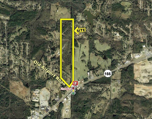
774 Old Airport Rd, Carrollton, GA 30116

NEARBY LISTINGS FOR SALE OR LEASE
Property Detail
774 Old Airport Rd
Atlanta-Sandy Springs-Roswell, GA
Terry Dobbins Inc Surv
C04-0220045
53.26AC/OLD AIRPORT RD CO131
Agriculturalland
Carroll
X
Georgia
13045C0260D
1
2025
53.26 AC
2025
Villa Rica/West Outlying
910709
Atlanta
DEMOGRAPHICS near 774 Old Airport Rd
1 Mile
3 Mile
5 Mile
2024 Total Population
1,757
17,497
44,922
2029 Population
1,951
19,369
49,884
Pop Growth 2024-2029
+ 11.04%
+ 10.70%
+ 11.05%
Average Age
36
37
36
2024 Total Households
637
6,397
16,074
HH Growth 2024-2029
+ 11.15%
+ 10.76%
+ 11.22%
Median Household Inc
$49,804
$51,649
$48,165
Avg Household Size
2.70
2.60
2.60
2024 Avg HH Vehicles
2.00
2.00
2.00
Median Home Value
$148,292
$180,615
$208,736
Median Year Built
1984
1987
1987
Nearby Places
Map Layers
Map Styles
 Street
 Aerial
- Restaurants
- Banks
- Shops
- Fitness
- Groceries
Nearby Properties
Address
Land Use
TOTAL SIZE
Lot Size
Zoning
Address
Land Use
TOTAL SIZE
Lot Size
Zoning
73,900 SF
10.57 AC
C2
Address
Land Use
TOTAL SIZE
Lot Size
Zoning
56,458 SF
21.87 AC
R3
Address
Land Use
TOTAL SIZE
Lot Size
Zoning
56,288 SF
4.69 AC
C2
Address
Land Use
TOTAL SIZE
Lot Size
Zoning
163,568 SF
16.80 AC
C2
Address
Land Use
TOTAL SIZE
Lot Size
Zoning
42,905 SF
9.76 AC
002
Address
Land Use
TOTAL SIZE
Lot Size
Zoning
90,485 SF
10.35 AC
C2
Address
Land Use
TOTAL SIZE
Lot Size
Zoning
13,299 SF
226.96 AC
R20
Address
Land Use
TOTAL SIZE
Lot Size
Zoning
45,480 SF
62.18 AC
R20
Address
Land Use
TOTAL SIZE
Lot Size
Zoning
135,902 SF
121.50 AC
A
Address
Land Use
TOTAL SIZE
Lot Size
Zoning
29,561 SF
5.89 AC
C2
Address
Land Use
TOTAL SIZE
Lot Size
Zoning
100.74 AC
PUD
Address
Land Use
TOTAL SIZE
Lot Size
Zoning
63,888 SF
8.40 AC
I
Address
Land Use
TOTAL SIZE
Lot Size
Zoning
96.23 AC
M1
Address
Land Use
TOTAL SIZE
Lot Size
Zoning
46,146 SF
5.74 AC
C
Address
Land Use
TOTAL SIZE
Lot Size
Zoning
39,147 SF
9 AC
R2
Address
Land Use
TOTAL SIZE
Lot Size
Zoning
27,572 SF
1.71 AC
C2
Address
Land Use
TOTAL SIZE
Lot Size
Zoning
22,580 SF
9.71 AC
R2
Address
Land Use
TOTAL SIZE
Lot Size
Zoning
32,390 SF
9.84 AC
R2
Address
Land Use
TOTAL SIZE
Lot Size
Zoning
22,800 SF
39.40 AC
M1
Address
Land Use
TOTAL SIZE
Lot Size
Zoning
13,632 SF
5 AC
R2
Address
Land Use
TOTAL SIZE
Lot Size
Zoning
34,158 SF
26.14 AC
A
Address
Land Use
TOTAL SIZE
Lot Size
Zoning
9,920 SF
1.17 AC
C2
Address
Land Use
TOTAL SIZE
Lot Size
Zoning
38,400 SF
4.77 AC
I
Address
Land Use
TOTAL SIZE
Lot Size
Zoning
38,182 SF
28.01 AC
C
Address
Land Use
TOTAL SIZE
Lot Size
Zoning
29,210 SF
9.06 AC
R2
Address
Land Use
TOTAL SIZE
Lot Size
Zoning
49,414 SF
8.80 AC
RM10
Address
Land Use
TOTAL SIZE
Lot Size
Zoning
5,121 SF
2.56 AC
C2
Address
Land Use
TOTAL SIZE
Lot Size
Zoning
33,076 SF
11.86 AC
COMM/AG
Address
Land Use
TOTAL SIZE
Lot Size
Zoning
13,694 SF
10.24 AC
C2
Address
Land Use
TOTAL SIZE
Lot Size
Zoning
67,902 SF
12.45 AC
C2
The World's #1 Commercial Real Estate Marketplace
Connect with us
© 2026 CoStar Group
The information above has been obtained from sources believed reliable. While we do not doubt its accuracy we have not verified it and make no guarantee, warranty or representation about it. It is your responsibility to independently confirm its accuracy and completeness. Any projections, opinions, assumptions, or estimates used are for example only and do not represent the current or future performance of the property. The value of this transaction to you depends on tax and other factors which should be evaluated by your tax, financial, and legal advisors. You and your advisors should conduct a careful, independent investigation of the property to determine to your satisfaction the suitability of the property for your needs.