Property Record
Old Airport Rd, Concord, NC 28025
NEARBY LISTINGS FOR SALE OR LEASE
-
-
View all Concord listings for sale on LoopNet.com
Property Detail
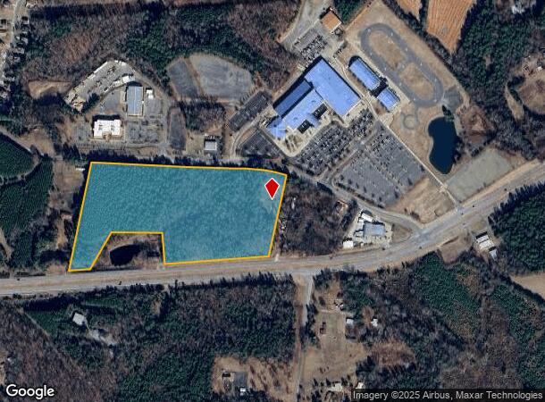
Old Airport Rd
Charlotte-Concord-Gastonia, NC-SC
East 7349
5559-19-5238-0000
S/S AIRPORT RD & N/S HWY 49
Commercialnec
Cabarrus
X
North Carolina
3710555900J
22.13 AC
2025
Cabarrus County
2025
Charlotte
042202
DEMOGRAPHICS near Old Airport Rd
1 Mile
3 Mile
5 Mile
2024 Total Population
1,443
10,437
44,926
2029 Population
1,617
11,735
50,583
Pop Growth 2024-2029
+ 12.06%
+ 12.44%
+ 12.59%
Average Age
40
41
39
2024 Total Households
518
3,890
16,089
HH Growth 2024-2029
+ 10.62%
+ 11.00%
+ 11.19%
Median Household Inc
$72,514
$70,149
$70,299
Avg Household Size
2.70
2.60
2.70
2024 Avg HH Vehicles
2.00
2.00
2.00
Median Home Value
$277,352
$268,053
$240,501
Median Year Built
1989
1986
1988
Nearby Places
Map Layers
Map Styles
 Street
 Aerial
- Restaurants
- Banks
- Shops
- Fitness
- Groceries
PUBLIC TRANSPORTATION
AIRPORT
Concord-Padgett Regional
DRIVE
WALK
Distance
Concord-Padgett Regional
29 min
17.1 mi
Charlotte/Douglas International
DRIVE
WALK
Distance
Charlotte/Douglas International
49 min
32.6 mi
Freight Ports
Port of Wilmington
DRIVE
WALK
Distance
Port of Wilmington
250 min
196.0 mi
Nearby Properties
Address
Land Use
TOTAL SIZE
Lot Size
Zoning
Address
Land Use
TOTAL SIZE
Lot Size
Zoning
46,811 SF
68.68 AC
PID
Address
Land Use
TOTAL SIZE
Lot Size
Zoning
158,606 SF
53.21 AC
O-I
Address
Land Use
TOTAL SIZE
Lot Size
Zoning
126,483 SF
28 AC
OI
Address
Land Use
TOTAL SIZE
Lot Size
Zoning
146,052 SF
98.84 AC
CR
Address
Land Use
TOTAL SIZE
Lot Size
Zoning
40,632 SF
28.71 AC
PID
Address
Land Use
TOTAL SIZE
Lot Size
Zoning
34,085 SF
4.26 AC
C-2
Address
Land Use
TOTAL SIZE
Lot Size
Zoning
14,060 SF
7.59 AC
LDR
Address
Land Use
TOTAL SIZE
Lot Size
Zoning
53.95 AC
C-2
Address
Land Use
TOTAL SIZE
Lot Size
Zoning
55,652 SF
7.33 AC
C-2
Address
Land Use
TOTAL SIZE
Lot Size
Zoning
70,500 SF
3.77 AC
GC
Address
Land Use
TOTAL SIZE
Lot Size
Zoning
9,518 SF
14 AC
GC
Address
Land Use
TOTAL SIZE
Lot Size
Zoning
15,359 SF
2.62 AC
C-2
Address
Land Use
TOTAL SIZE
Lot Size
Zoning
12,816 SF
2.35 AC
C-2
Address
Land Use
TOTAL SIZE
Lot Size
Zoning
14,264 SF
12.43 AC
CR
Address
Land Use
TOTAL SIZE
Lot Size
Zoning
11,741 SF
106.41 AC
CR
Address
Land Use
TOTAL SIZE
Lot Size
Zoning
24,577 SF
12.09 AC
O-I
Address
Land Use
TOTAL SIZE
Lot Size
Zoning
85.43 AC
CR
Address
Land Use
TOTAL SIZE
Lot Size
Zoning
5,946 SF
9.20 AC
O-I
Address
Land Use
TOTAL SIZE
Lot Size
Zoning
4,391 SF
1.20 AC
C-2
Address
Land Use
TOTAL SIZE
Lot Size
Zoning
23,418 SF
2.94 AC
C-2
Address
Land Use
TOTAL SIZE
Lot Size
Zoning
8,734 SF
1.39 AC
C-2
Address
Land Use
TOTAL SIZE
Lot Size
Zoning
6,095 SF
3.89 AC
C-2
Address
Land Use
TOTAL SIZE
Lot Size
Zoning
7,174 SF
3.46 AC
CR
Address
Land Use
TOTAL SIZE
Lot Size
Zoning
101.37 AC
AO
Address
Land Use
TOTAL SIZE
Lot Size
Zoning
96.31 AC
CR
Address
Land Use
TOTAL SIZE
Lot Size
Zoning
4,572 SF
4 AC
CR
Address
Land Use
TOTAL SIZE
Lot Size
Zoning
10,980 SF
5.57 AC
O-I
Address
Land Use
TOTAL SIZE
Lot Size
Zoning
12,839 SF
6.47 AC
RM-1
Address
Land Use
TOTAL SIZE
Lot Size
Zoning
7,536 SF
0.80 AC
C-2
Address
Land Use
TOTAL SIZE
Lot Size
Zoning
6,394 SF
26.46 AC
CR
The World's #1 Commercial Real Estate Marketplace
Connect with us
© 2026 CoStar Group
The information above has been obtained from sources believed reliable. While we do not doubt its accuracy we have not verified it and make no guarantee, warranty or representation about it. It is your responsibility to independently confirm its accuracy and completeness. Any projections, opinions, assumptions, or estimates used are for example only and do not represent the current or future performance of the property. The value of this transaction to you depends on tax and other factors which should be evaluated by your tax, financial, and legal advisors. You and your advisors should conduct a careful, independent investigation of the property to determine to your satisfaction the suitability of the property for your needs.