Property Record
Old Carnesville Rd, , GA

Property Detail
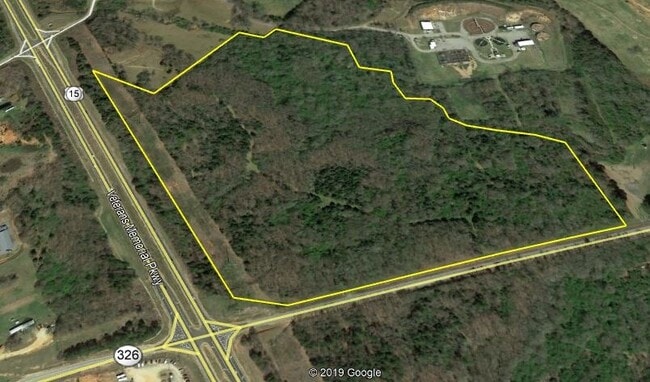
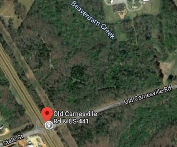
Old Carnesville Rd
009-004B
TRACTS 2 & 3 PLAT BK 32 PG 105
Agriculturalland
JACKSON
002
Georgia
A Areas with a 1% annual chance of flooding and a 26% chance of flooding over the life of a 30-year mortgage.
48.73 AC
2025
Jackson County
2025
Atlanta
010300
Jefferson, GA
NEARBY LISTINGS FOR SALE OR LEASE
DEMOGRAPHICS near Old Carnesville Rd
1 mile
3 mile
5 mile
2024 Total Population
1,642
11,703
17,345
2029 Population
1,948
13,738
20,186
Pop Growth 2024-2029
+ 18.64%
+ 17.39%
+ 16.38%
Average Age
39
39
40
2024 Total Households
633
4,417
6,448
HH Growth 2024-2029
+ 18.80%
+ 17.55%
+ 16.50%
Median Household Inc
$64,700
$70,212
$66,428
Avg Household Size
2.60
2.60
2.60
2024 Avg HH Vehicles
2.00
2.00
2.00
Median Home Value
$254,069
$295,060
$299,777
Median Year Built
1989
1989
1990
Nearby Places
Map Layers
Map Styles
 Street
 Aerial
Transit
 Traffic
 Biking
Places
Listings with unknown addresses are not visible on the map
- Restaurants
- Banks
- Shops
- Fitness
- Groceries
SALE & LEASE HISTORY
LISTING DATE
SALE/LEASE

Jan 27, 2020
For Sale
Nearby Properties
Address
Land Use
TOTAL SIZE
Lot Size
Zoning
Address
Land Use
TOTAL SIZE
Lot Size
Zoning
14.17 AC
001
Address
Land Use
TOTAL SIZE
Lot Size
Zoning
64,666 SF
16.89 AC
MI
Address
Land Use
TOTAL SIZE
Lot Size
Zoning
1,208 SF
106.45 AC
M1
Address
Land Use
TOTAL SIZE
Lot Size
Zoning
9,706 SF
1.65 AC
E1
Address
Land Use
TOTAL SIZE
Lot Size
Zoning
40,000 SF
0.94 AC
002
Address
Land Use
TOTAL SIZE
Lot Size
Zoning
1.07 AC
OCR
Address
Land Use
TOTAL SIZE
Lot Size
Zoning
962,280 SF
74.52 AC
MI
Address
Land Use
TOTAL SIZE
Lot Size
Zoning
1 AC
CBD
Address
Land Use
TOTAL SIZE
Lot Size
Zoning
1 AC
CBD
Address
Land Use
TOTAL SIZE
Lot Size
Zoning
1,350 SF
0.72 AC
CBD
Address
Land Use
TOTAL SIZE
Lot Size
Zoning
126,216 SF
14.49 AC
E1
Address
Land Use
TOTAL SIZE
Lot Size
Zoning
110,920 SF
49.30 AC
001
Address
Land Use
TOTAL SIZE
Lot Size
Zoning
86,931 SF
54.41 AC
001
Address
Land Use
TOTAL SIZE
Lot Size
Zoning
101,750 SF
17.02 AC
C2
Address
Land Use
TOTAL SIZE
Lot Size
Zoning
0.51 AC
Address
Land Use
TOTAL SIZE
Lot Size
Zoning
151,192 SF
27.32 AC
C2
Address
Land Use
TOTAL SIZE
Lot Size
Zoning
38 AC
AR
Address
Land Use
TOTAL SIZE
Lot Size
Zoning
89,000 SF
12.50 AC
M1
Address
Land Use
TOTAL SIZE
Lot Size
Zoning
84,742 SF
23.90 AC
001
Address
Land Use
TOTAL SIZE
Lot Size
Zoning
0.28 AC
CBD
Address
Land Use
TOTAL SIZE
Lot Size
Zoning
7,980 SF
15 AC
002
Address
Land Use
TOTAL SIZE
Lot Size
Zoning
13,398 SF
15 AC
B2
Address
Land Use
TOTAL SIZE
Lot Size
Zoning
0.30 AC
001
Address
Land Use
TOTAL SIZE
Lot Size
Zoning
0.29 AC
E1
Address
Land Use
TOTAL SIZE
Lot Size
Zoning
114,246 SF
15.02 AC
C2
Address
Land Use
TOTAL SIZE
Lot Size
Zoning
4,584 SF
0.14 AC
E1
Address
Land Use
TOTAL SIZE
Lot Size
Zoning
89,642 SF
96.31 AC
003
Address
Land Use
TOTAL SIZE
Lot Size
Zoning
32,616 SF
7.17 AC
OCR
Address
Land Use
TOTAL SIZE
Lot Size
Zoning
28,800 SF
24.67 AC
MI
Address
Land Use
TOTAL SIZE
Lot Size
Zoning
4,072 SF
5.12 AC
C2
The World's #1 Commercial Real Estate Marketplace
Connect with us
© 2026 CoStar Group
The information above has been obtained from sources believed reliable. While we do not doubt its accuracy we have not verified it and make no guarantee, warranty or representation about it. It is your responsibility to independently confirm its accuracy and completeness. Any projections, opinions, assumptions, or estimates used are for example only and do not represent the current or future performance of the property. The value of this transaction to you depends on tax and other factors which should be evaluated by your tax, financial, and legal advisors. You and your advisors should conduct a careful, independent investigation of the property to determine to your satisfaction the suitability of the property for your needs.