Property Record
Old Cedarfield Dr, Blacksburg, VA 24060
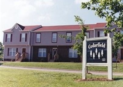

Property Detail
Old Cedarfield Dr
001793
CEDAR RUN CEDARFIELD PH III
Multifamilydwelling
MONTGOMERY
RM-48
Virginia
B and X Area of moderate flood hazard, usually the area between the limits of the 100-year and 500-year floods.
9.39 AC
2025
Ellett-Jennelle
2025
Other Market Areas
020100
Blacksburg-Christiansburg-Radford, VA
36,702 SF
NEARBY LISTINGS FOR SALE OR LEASE
-
-
View all Blacksburg listings for sale on LoopNet.com
DEMOGRAPHICS near Old Cedarfield Dr
1 mile
3 mile
5 mile
2025 Total Population
4,437
22,685
56,498
2030 Population
4,485
22,702
56,629
Pop Growth 2025-2030
+ 1.08%
+ 0.07%
+ 0.23%
Average Age
34
35
36
2025 Total Households
2,127
10,265
24,189
HH Growth 2025-2030
+ 1.13%
+ 0.13%
+ 0.25%
Median Household Inc
$46,521
$50,123
$60,482
Avg Household Size
2.10
2.10
2.30
2025 Avg HH Vehicles
2.00
2.00
2.00
Median Home Value
$479,999
$432,271
$362,855
Median Year Built
1986
1983
1988
Nearby Places
Map Layers
Map Styles
 Street
 Aerial
Layers
 Traffic
 Biking
Places
Listings with unknown addresses are not visible on the map
- Restaurants
- Banks
- Shops
- Fitness
- Groceries
PUBLIC TRANSPORTATION
AIRPORT
Roanoke/Blacksburg Regional (Woodrum Field)
Drive
Walk
Distance
Roanoke/Blacksburg Regional (Woodrum Field)
55 min
38.6 mi
Freight Ports
Virginia Port Authority - Richmond
Drive
Walk
Distance
Virginia Port Authority - Richmond
257 min
222.5 mi
Nearby Properties
Address
Land Use
TOTAL SIZE
Lot Size
Zoning
Address
Land Use
TOTAL SIZE
Lot Size
Zoning
120,948 SF
15.28 AC
RM-48
Address
Land Use
TOTAL SIZE
Lot Size
Zoning
3.23 AC
DC
Address
Land Use
TOTAL SIZE
Lot Size
Zoning
47,153 SF
30.90 AC
R&D
Address
Land Use
TOTAL SIZE
Lot Size
Zoning
50,000 SF
25.93 AC
R&D
Address
Land Use
TOTAL SIZE
Lot Size
Zoning
96,768 SF
20.18 AC
RM1
Address
Land Use
TOTAL SIZE
Lot Size
Zoning
4,332 SF
24.35 AC
RM-48
Address
Land Use
TOTAL SIZE
Lot Size
Zoning
189,259 SF
31.06 AC
R&D
Address
Land Use
TOTAL SIZE
Lot Size
Zoning
7.38 AC
R&D
Address
Land Use
TOTAL SIZE
Lot Size
Zoning
197,024 SF
9.86 AC
PR
Address
Land Use
TOTAL SIZE
Lot Size
Zoning
183,569 SF
8.38 AC
PR
Address
Land Use
TOTAL SIZE
Lot Size
Zoning
33,716 SF
15.72 AC
R&D
Address
Land Use
TOTAL SIZE
Lot Size
Zoning
140,302 SF
1.09 AC
DC
Address
Land Use
TOTAL SIZE
Lot Size
Zoning
7,820 SF
58.14 AC
R&D
Address
Land Use
TOTAL SIZE
Lot Size
Zoning
5.58 AC
MXD
Address
Land Use
TOTAL SIZE
Lot Size
Zoning
3.47 AC
MXD
Address
Land Use
TOTAL SIZE
Lot Size
Zoning
6.48 AC
GC
Address
Land Use
TOTAL SIZE
Lot Size
Zoning
66,896 SF
4 AC
O
Address
Land Use
TOTAL SIZE
Lot Size
Zoning
51,036 SF
14.21 AC
R&D
Address
Land Use
TOTAL SIZE
Lot Size
Zoning
3,654 SF
3.72 AC
RM-48
Address
Land Use
TOTAL SIZE
Lot Size
Zoning
57,936 SF
10.38 AC
R&D
Address
Land Use
TOTAL SIZE
Lot Size
Zoning
2.08 AC
GC
Address
Land Use
TOTAL SIZE
Lot Size
Zoning
95,793 SF
6.95 AC
PR
Address
Land Use
TOTAL SIZE
Lot Size
Zoning
149,655 SF
12.51 AC
GC
Address
Land Use
TOTAL SIZE
Lot Size
Zoning
12,893 SF
13.07 AC
GC
Address
Land Use
TOTAL SIZE
Lot Size
Zoning
1.57 AC
R-4
Address
Land Use
TOTAL SIZE
Lot Size
Zoning
111,796 SF
15.03 AC
IN
Address
Land Use
TOTAL SIZE
Lot Size
Zoning
60,264 SF
7.25 AC
RM-27
Address
Land Use
TOTAL SIZE
Lot Size
Zoning
94,900 SF
6.95 AC
PR
Address
Land Use
TOTAL SIZE
Lot Size
Zoning
19,668 SF
9.59 AC
RM-48
Address
Land Use
TOTAL SIZE
Lot Size
Zoning
253,134 SF
1.60 AC
DC
The World's #1 Commercial Real Estate Marketplace
Connect with us
© 2026 CoStar Group
The information above has been obtained from sources believed reliable. While we do not doubt its accuracy we have not verified it and make no guarantee, warranty or representation about it. It is your responsibility to independently confirm its accuracy and completeness. Any projections, opinions, assumptions, or estimates used are for example only and do not represent the current or future performance of the property. The value of this transaction to you depends on tax and other factors which should be evaluated by your tax, financial, and legal advisors. You and your advisors should conduct a careful, independent investigation of the property to determine to your satisfaction the suitability of the property for your needs.