Property Record
Old Columbus Rd, Springfield, OH 45503
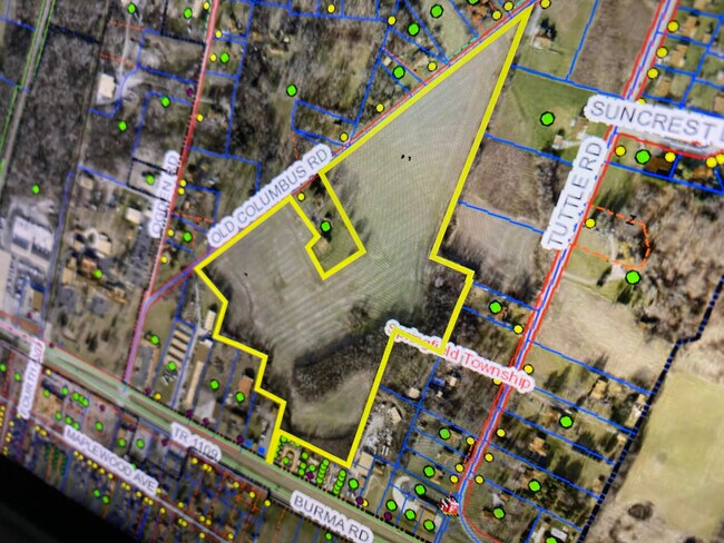

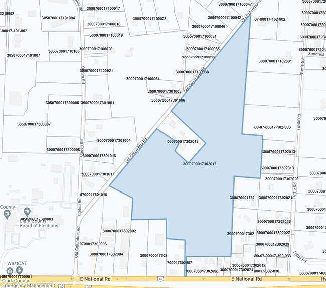
Property Detail
Old Columbus Rd
Springfield, OH
N W & S W QRS
30-00700-01730-2017
CLARK
Agriculturalland
Ohio
R-1
17
B and X Area of moderate flood hazard, usually the area between the limits of the 100-year and 500-year floods.
31.11 AC
2024
Northeast Dayton
2025
Cincinnati/Dayton
002403
NEARBY LISTINGS FOR SALE OR LEASE
DEMOGRAPHICS near Old Columbus Rd
1 mile
3 mile
5 mile
2025 Total Population
5,602
36,563
78,369
2030 Population
5,612
36,625
78,530
Pop Growth 2025-2030
+ 0.18%
+ 0.17%
+ 0.21%
Average Age
41
39
41
2025 Total Households
2,392
15,285
32,659
HH Growth 2025-2030
+ 0.25%
+ 0.12%
+ 0.15%
Median Household Inc
$55,810
$48,954
$51,487
Avg Household Size
2.30
2.30
2.30
2025 Avg HH Vehicles
2.00
2.00
2.00
Median Home Value
$151,116
$128,292
$151,930
Median Year Built
1957
1951
1956
Nearby Places
Map Layers
Map Styles
 Street
 Aerial
Transit
 Traffic
 Biking
Places
Listings with unknown addresses are not visible on the map
- Restaurants
- Banks
- Shops
- Fitness
- Groceries
PUBLIC TRANSPORTATION
AIRPORT
James M Cox Dayton International
Drive
Walk
Distance
James M Cox Dayton International
39 min
29.7 mi
Freight Ports
Port of Toledo
Drive
Walk
Distance
Port of Toledo
193 min
133.6 mi
SALE & LEASE HISTORY
LISTING DATE
SALE/LEASE

Nov 28, 2022
For Sale
Nearby Properties
Address
Land Use
TOTAL SIZE
Lot Size
Zoning
Address
Land Use
TOTAL SIZE
Lot Size
Zoning
878,848 SF
115.07 AC
Address
Land Use
TOTAL SIZE
Lot Size
Zoning
399,308 SF
11.06 AC
Address
Land Use
TOTAL SIZE
Lot Size
Zoning
107.87 AC
Address
Land Use
TOTAL SIZE
Lot Size
Zoning
103,458 SF
5.51 AC
Address
Land Use
TOTAL SIZE
Lot Size
Zoning
12,657 SF
8.17 AC
Address
Land Use
TOTAL SIZE
Lot Size
Zoning
399,308 SF
11.06 AC
Address
Land Use
TOTAL SIZE
Lot Size
Zoning
516,191 SF
91.52 AC
A
Address
Land Use
TOTAL SIZE
Lot Size
Zoning
386,728 SF
34.66 AC
Address
Land Use
TOTAL SIZE
Lot Size
Zoning
375,053 SF
50.43 AC
Address
Land Use
TOTAL SIZE
Lot Size
Zoning
8,316 SF
34.41 AC
R-1
Address
Land Use
TOTAL SIZE
Lot Size
Zoning
25.44 AC
Address
Land Use
TOTAL SIZE
Lot Size
Zoning
Address
Land Use
TOTAL SIZE
Lot Size
Zoning
199,566 SF
109.96 AC
Address
Land Use
TOTAL SIZE
Lot Size
Zoning
229,125 SF
40.19 AC
Address
Land Use
TOTAL SIZE
Lot Size
Zoning
6,521 SF
94.30 AC
Address
Land Use
TOTAL SIZE
Lot Size
Zoning
Address
Land Use
TOTAL SIZE
Lot Size
Zoning
Address
Land Use
TOTAL SIZE
Lot Size
Zoning
878,588 SF
115.07 AC
Address
Land Use
TOTAL SIZE
Lot Size
Zoning
217,626 SF
17.85 AC
Address
Land Use
TOTAL SIZE
Lot Size
Zoning
36,172 SF
2.14 AC
Address
Land Use
TOTAL SIZE
Lot Size
Zoning
Address
Land Use
TOTAL SIZE
Lot Size
Zoning
399,308 SF
31.78 AC
Address
Land Use
TOTAL SIZE
Lot Size
Zoning
1.05 AC
Address
Land Use
TOTAL SIZE
Lot Size
Zoning
Address
Land Use
TOTAL SIZE
Lot Size
Zoning
20,448 SF
7.35 AC
Address
Land Use
TOTAL SIZE
Lot Size
Zoning
74,122 SF
3.39 AC
Address
Land Use
TOTAL SIZE
Lot Size
Zoning
197,451 SF
9.49 AC
Address
Land Use
TOTAL SIZE
Lot Size
Zoning
36,858 SF
17.81 AC
Address
Land Use
TOTAL SIZE
Lot Size
Zoning
Address
Land Use
TOTAL SIZE
Lot Size
Zoning
50,170 SF
7.09 AC
The World's #1 Commercial Real Estate Marketplace
Connect with us
© 2026 CoStar Group
The information above has been obtained from sources believed reliable. While we do not doubt its accuracy we have not verified it and make no guarantee, warranty or representation about it. It is your responsibility to independently confirm its accuracy and completeness. Any projections, opinions, assumptions, or estimates used are for example only and do not represent the current or future performance of the property. The value of this transaction to you depends on tax and other factors which should be evaluated by your tax, financial, and legal advisors. You and your advisors should conduct a careful, independent investigation of the property to determine to your satisfaction the suitability of the property for your needs.