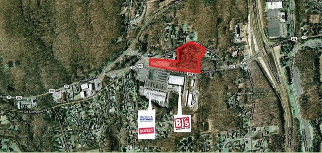
Property Record
Old Crompond Rd, Yorktown Heights, NY 10598

Current Lease Availabilities
NEARBY LISTINGS FOR SALE OR LEASE
Property Detail
Old Crompond Rd
5400-026-018-00001-000-0026
Westchester
Commercialacreage
New York
A
25.000
36119C0037F
1.02 AC
2025
Northwest
2024
Westchester/So Connecticut
014805
New York-Jersey City-White Plains, NY-NJ
DEMOGRAPHICS near Old Crompond Rd
1 Mile
3 Mile
5 Mile
2024 Total Population
2,679
32,785
86,824
2029 Population
2,622
31,918
84,824
Pop Growth 2024-2029
(2.13%)
(2.64%)
(2.30%)
Average Age
43
43
43
2024 Total Households
845
11,585
30,931
HH Growth 2024-2029
(2.37%)
(2.91%)
(2.51%)
Median Household Inc
$197,367
$145,809
$125,704
Avg Household Size
2.90
2.70
2.70
2024 Avg HH Vehicles
2.00
2.00
2.00
Median Home Value
$577,869
$507,367
$469,867
Median Year Built
1961
1965
1965
Nearby Places
Map Layers
Map Styles
 Street
 Aerial
- Restaurants
- Banks
- Shops
- Fitness
- Groceries
PUBLIC TRANSPORTATION
COMMUTER RAIL
Peekskill Station (Hudson Line - Metro-North Commuter Railroad Company (Metro-North))
DRIVE
WALK
Distance
Peekskill Station (Hudson Line - Metro-North Commuter Railroad Company (Metro-North))
10 min
6.1 mi
Cortlandt Station (Hudson Line - Metro-North Commuter Railroad Company (Metro-North))
DRIVE
WALK
Distance
Cortlandt Station (Hudson Line - Metro-North Commuter Railroad Company (Metro-North))
18 min
9.2 mi
AIRPORT
Westchester County
DRIVE
WALK
Distance
Westchester County
32 min
24.3 mi
New York Stewart International
DRIVE
WALK
Distance
New York Stewart International
50 min
29.3 mi
Freight Ports
NY - Red Hook Container Terminal
DRIVE
WALK
Distance
NY - Red Hook Container Terminal
74 min
51.7 mi
Nearby Properties
Address
Land Use
TOTAL SIZE
Lot Size
Zoning
Address
Land Use
TOTAL SIZE
Lot Size
Zoning
Address
Land Use
TOTAL SIZE
Lot Size
Zoning
878 SF
62.50 AC
R1-20
Address
Land Use
TOTAL SIZE
Lot Size
Zoning
Address
Land Use
TOTAL SIZE
Lot Size
Zoning
13 AC
R1-40
Address
Land Use
TOTAL SIZE
Lot Size
Zoning
Address
Land Use
TOTAL SIZE
Lot Size
Zoning
Address
Land Use
TOTAL SIZE
Lot Size
Zoning
1,124 SF
8 AC
R1-80
Address
Land Use
TOTAL SIZE
Lot Size
Zoning
2,241 SF
595 AC
R1-16
Address
Land Use
TOTAL SIZE
Lot Size
Zoning
Address
Land Use
TOTAL SIZE
Lot Size
Zoning
82.53 AC
Address
Land Use
TOTAL SIZE
Lot Size
Zoning
1,504 SF
45.28 AC
R1-80
Address
Land Use
TOTAL SIZE
Lot Size
Zoning
Address
Land Use
TOTAL SIZE
Lot Size
Zoning
Address
Land Use
TOTAL SIZE
Lot Size
Zoning
38.05 AC
Address
Land Use
TOTAL SIZE
Lot Size
Zoning
12 AC
R1-40
Address
Land Use
TOTAL SIZE
Lot Size
Zoning
1,449 SF
580 AC
R1-16
Address
Land Use
TOTAL SIZE
Lot Size
Zoning
Address
Land Use
TOTAL SIZE
Lot Size
Zoning
35.97 AC
Address
Land Use
TOTAL SIZE
Lot Size
Zoning
1,642 SF
11.50 AC
R1-20
Address
Land Use
TOTAL SIZE
Lot Size
Zoning
64.38 AC
Address
Land Use
TOTAL SIZE
Lot Size
Zoning
12.38 AC
R1-40
Address
Land Use
TOTAL SIZE
Lot Size
Zoning
38.76 AC
CRC
Address
Land Use
TOTAL SIZE
Lot Size
Zoning
10.19 AC
R1-40
Address
Land Use
TOTAL SIZE
Lot Size
Zoning
1,809 SF
4.33 AC
C-2R
Address
Land Use
TOTAL SIZE
Lot Size
Zoning
Address
Land Use
TOTAL SIZE
Lot Size
Zoning
Address
Land Use
TOTAL SIZE
Lot Size
Zoning
9.77 AC
IN
Address
Land Use
TOTAL SIZE
Lot Size
Zoning
14.94 AC
C-1
Address
Land Use
TOTAL SIZE
Lot Size
Zoning
Address
Land Use
TOTAL SIZE
Lot Size
Zoning
879 SF
24.13 AC
OB
The World's #1 Commercial Real Estate Marketplace
Connect with us
© 2025 CoStar Group
The information above has been obtained from sources believed reliable. While we do not doubt its accuracy we have not verified it and make no guarantee, warranty or representation about it. It is your responsibility to independently confirm its accuracy and completeness. Any projections, opinions, assumptions, or estimates used are for example only and do not represent the current or future performance of the property. The value of this transaction to you depends on tax and other factors which should be evaluated by your tax, financial, and legal advisors. You and your advisors should conduct a careful, independent investigation of the property to determine to your satisfaction the suitability of the property for your needs.