Property Record
Old Franklin Tpke, Rocky Mount, VA 24151
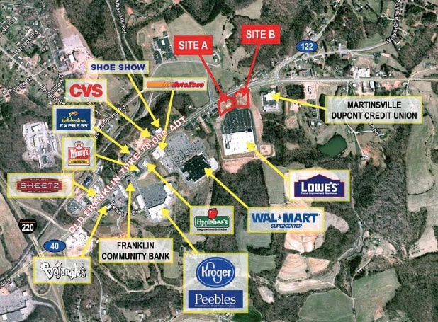

This Property Is For Sale
Property Detail
Old Franklin Tpke
2020002200
RT 40 NEW TRACT 1
Commercialacreage
FRANKLIN
GB
Virginia
B and X Area of moderate flood hazard, usually the area between the limits of the 100-year and 500-year floods.
1.33 AC
2025
South Franklin County
2025
Roanoke
020801
Roanoke, VA
NEARBY LISTINGS FOR SALE OR LEASE
-
-
View all Rocky Mount listings for sale on LoopNet.com
DEMOGRAPHICS near Old Franklin Tpke
1 mile
3 mile
5 mile
2025 Total Population
663
6,750
13,903
2030 Population
654
6,672
13,751
Pop Growth 2025-2030
(1.36%)
(1.16%)
(1.09%)
Average Age
43
42
42
2025 Total Households
295
2,920
5,849
HH Growth 2025-2030
(1.69%)
(1.40%)
(1.32%)
Median Household Inc
$80,580
$61,540
$64,334
Avg Household Size
2.30
2.20
2.30
2025 Avg HH Vehicles
3.00
2.00
2.00
Median Home Value
$212,500
$186,423
$203,439
Median Year Built
1984
1977
1978
Nearby Places
Map Layers
Map Styles
 Street
 Aerial
Layers
 Traffic
 Biking
Places
Listings with unknown addresses are not visible on the map
- Restaurants
- Banks
- Shops
- Fitness
- Groceries
PUBLIC TRANSPORTATION
AIRPORT
Roanoke/Blacksburg Regional (Woodrum Field)
Drive
Walk
Distance
Roanoke/Blacksburg Regional (Woodrum Field)
42 min
29.9 mi
Freight Ports
Virginia Port Authority - Richmond
Drive
Walk
Distance
Virginia Port Authority - Richmond
228 min
167.6 mi
Nearby Properties
Address
Land Use
TOTAL SIZE
Lot Size
Zoning
Address
Land Use
TOTAL SIZE
Lot Size
Zoning
131,046 SF
32.45 AC
POS
Address
Land Use
TOTAL SIZE
Lot Size
Zoning
96,370 SF
32.42 AC
POS
Address
Land Use
TOTAL SIZE
Lot Size
Zoning
63,050 SF
15 AC
C1
Address
Land Use
TOTAL SIZE
Lot Size
Zoning
47,686 SF
3.10 AC
CBD
Address
Land Use
TOTAL SIZE
Lot Size
Zoning
54,056 SF
13.35 AC
GB
Address
Land Use
TOTAL SIZE
Lot Size
Zoning
153,292 SF
35.07 AC
GB
Address
Land Use
TOTAL SIZE
Lot Size
Zoning
50,708 SF
17.03 AC
GB
Address
Land Use
TOTAL SIZE
Lot Size
Zoning
54,377 SF
8.44 AC
C1
Address
Land Use
TOTAL SIZE
Lot Size
Zoning
136,420 SF
35.66 AC
GB
Address
Land Use
TOTAL SIZE
Lot Size
Zoning
52,205 SF
6.15 AC
R2
Address
Land Use
TOTAL SIZE
Lot Size
Zoning
70,122 SF
15.97 AC
GB
Address
Land Use
TOTAL SIZE
Lot Size
Zoning
49,482 SF
CBD
Address
Land Use
TOTAL SIZE
Lot Size
Zoning
61,498 SF
12.67 AC
R1
Address
Land Use
TOTAL SIZE
Lot Size
Zoning
39,180 SF
4.32 AC
CBD
Address
Land Use
TOTAL SIZE
Lot Size
Zoning
71,079 SF
16.70 AC
POS
Address
Land Use
TOTAL SIZE
Lot Size
Zoning
508,300 SF
37.84 AC
M1
Address
Land Use
TOTAL SIZE
Lot Size
Zoning
45.10 AC
A1
Address
Land Use
TOTAL SIZE
Lot Size
Zoning
265,449 SF
12.25 AC
M2
Address
Land Use
TOTAL SIZE
Lot Size
Zoning
100,000 SF
10.51 AC
M1
Address
Land Use
TOTAL SIZE
Lot Size
Zoning
44,994 SF
15 AC
POS
Address
Land Use
TOTAL SIZE
Lot Size
Zoning
189,640 SF
17.98 AC
M1
Address
Land Use
TOTAL SIZE
Lot Size
Zoning
71,830 SF
17.41 AC
M2
Address
Land Use
TOTAL SIZE
Lot Size
Zoning
41,971 SF
4.50 AC
GB
Address
Land Use
TOTAL SIZE
Lot Size
Zoning
104,382 SF
25.06 AC
M1
Address
Land Use
TOTAL SIZE
Lot Size
Zoning
30,954 SF
2.46 AC
C1
Address
Land Use
TOTAL SIZE
Lot Size
Zoning
25,720 SF
41.19 AC
SM
Address
Land Use
TOTAL SIZE
Lot Size
Zoning
31,080 SF
1.18 AC
CBD
Address
Land Use
TOTAL SIZE
Lot Size
Zoning
377,400 SF
20.30 AC
M1
Address
Land Use
TOTAL SIZE
Lot Size
Zoning
25,036 SF
1.70 AC
GB
Address
Land Use
TOTAL SIZE
Lot Size
Zoning
14,616 SF
1.38 AC
The World's #1 Commercial Real Estate Marketplace
Connect with us
© 2026 CoStar Group
The information above has been obtained from sources believed reliable. While we do not doubt its accuracy we have not verified it and make no guarantee, warranty or representation about it. It is your responsibility to independently confirm its accuracy and completeness. Any projections, opinions, assumptions, or estimates used are for example only and do not represent the current or future performance of the property. The value of this transaction to you depends on tax and other factors which should be evaluated by your tax, financial, and legal advisors. You and your advisors should conduct a careful, independent investigation of the property to determine to your satisfaction the suitability of the property for your needs.