Property Record
590 Kings Pl, Riverdale, GA 30296
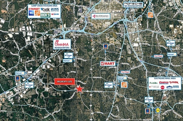
This Property Is For Sale
NEARBY LISTINGS FOR SALE OR LEASE
Property Detail
590 Kings Pl
13-0188-LL-161-8
Lake Royale
Sfr
Fulton
X
Georgia
13063C0062F
188
2024
0.17 AC
2025
North Clayton/Airport
010537
Atlanta
2,538 SF
Atlanta-Sandy Springs-Roswell, GA
DEMOGRAPHICS near 590 Kings Pl
1 Mile
3 Mile
5 Mile
2024 Total Population
4,714
52,276
158,957
2029 Population
4,832
53,206
161,586
Pop Growth 2024-2029
+ 2.50%
+ 1.78%
+ 1.65%
Average Age
38
39
37
2024 Total Households
1,540
18,576
59,317
HH Growth 2024-2029
+ 2.66%
+ 1.80%
+ 1.63%
Median Household Inc
$69,113
$64,323
$53,336
Avg Household Size
2.90
2.70
2.60
2024 Avg HH Vehicles
2.00
2.00
2.00
Median Home Value
$226,930
$188,087
$174,596
Median Year Built
1996
1989
1987
Nearby Places
- Restaurants
- Banks
- Shops
- Fitness
- Groceries
PUBLIC TRANSPORTATION
AIRPORT
Hartsfield - Jackson Atlanta International
DRIVE
WALK
Distance
Hartsfield - Jackson Atlanta International
19 min
9.4 mi
Freight Ports
Georgia Ports - Savannah
DRIVE
WALK
Distance
Georgia Ports - Savannah
274 min
241.7 mi
Nearby Properties
Address
Land Use
TOTAL SIZE
Lot Size
Zoning
Address
Land Use
TOTAL SIZE
Lot Size
Zoning
294 SF
21.17 AC
PUD
Address
Land Use
TOTAL SIZE
Lot Size
Zoning
3,904,656 SF
30.58 AC
RM
Address
Land Use
TOTAL SIZE
Lot Size
Zoning
278 SF
18.53 AC
PUD
Address
Land Use
TOTAL SIZE
Lot Size
Zoning
57.05 AC
GB
Address
Land Use
TOTAL SIZE
Lot Size
Zoning
147,540 SF
47.10 AC
C RP
Address
Land Use
TOTAL SIZE
Lot Size
Zoning
481 SF
90.43 AC
RMH
Address
Land Use
TOTAL SIZE
Lot Size
Zoning
257,723 SF
28.76 AC
C1
Address
Land Use
TOTAL SIZE
Lot Size
Zoning
213 SF
16.60 AC
C
Address
Land Use
TOTAL SIZE
Lot Size
Zoning
176 SF
17.67 AC
RM
Address
Land Use
TOTAL SIZE
Lot Size
Zoning
214 SF
20.97 AC
C
Address
Land Use
TOTAL SIZE
Lot Size
Zoning
200 SF
11 AC
C
Address
Land Use
TOTAL SIZE
Lot Size
Zoning
137,872 SF
14.23 AC
Address
Land Use
TOTAL SIZE
Lot Size
Zoning
138,822 SF
15.49 AC
C
Address
Land Use
TOTAL SIZE
Lot Size
Zoning
93,568 SF
15.84 AC
R4C
Address
Land Use
TOTAL SIZE
Lot Size
Zoning
95,422 SF
17.28 AC
Address
Land Use
TOTAL SIZE
Lot Size
Zoning
86,781 SF
16 AC
RS110
Address
Land Use
TOTAL SIZE
Lot Size
Zoning
138,852 SF
6.72 AC
C CH
Address
Land Use
TOTAL SIZE
Lot Size
Zoning
105,795 SF
13.55 AC
C
Address
Land Use
TOTAL SIZE
Lot Size
Zoning
132,252 SF
14.33 AC
C1C
Address
Land Use
TOTAL SIZE
Lot Size
Zoning
106 SF
10.19 AC
RM
Address
Land Use
TOTAL SIZE
Lot Size
Zoning
39,498 SF
28.80 AC
GB
Address
Land Use
TOTAL SIZE
Lot Size
Zoning
97,408 SF
16.01 AC
C1
Address
Land Use
TOTAL SIZE
Lot Size
Zoning
78,669 SF
16.60 AC
C
Address
Land Use
TOTAL SIZE
Lot Size
Zoning
49.20 AC
MX
Address
Land Use
TOTAL SIZE
Lot Size
Zoning
84,682 SF
9.32 AC
C
Address
Land Use
TOTAL SIZE
Lot Size
Zoning
91,767 SF
19.83 AC
R4
Address
Land Use
TOTAL SIZE
Lot Size
Zoning
100,000 SF
8.96 AC
AG1
Address
Land Use
TOTAL SIZE
Lot Size
Zoning
103,897 SF
14.92 AC
C
Address
Land Use
TOTAL SIZE
Lot Size
Zoning
40,014 SF
10.42 AC
GB
Address
Land Use
TOTAL SIZE
Lot Size
Zoning
108 SF
10.82 AC
RM
The World's #1 Commercial Real Estate Marketplace
Connect with us
© 2025 CoStar Group
The information above has been obtained from sources believed reliable. While we do not doubt its accuracy we have not verified it and make no guarantee, warranty or representation about it. It is your responsibility to independently confirm its accuracy and completeness. Any projections, opinions, assumptions, or estimates used are for example only and do not represent the current or future performance of the property. The value of this transaction to you depends on tax and other factors which should be evaluated by your tax, financial, and legal advisors. You and your advisors should conduct a careful, independent investigation of the property to determine to your satisfaction the suitability of the property for your needs.