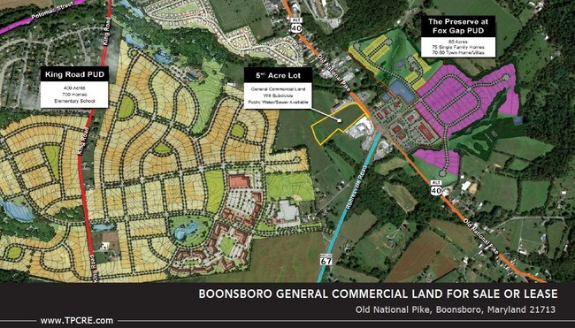
Property Record
Old National Pike, Boonsboro, MD 21713


Save to a Folder
{{folder.Name}}
{{folder.ListingIds.length}} Properties
{{folder.ListingIds.length}} Property
Create a New Folder
Property Detail
Old National Pike
Hagerstown-Martinsburg, MD-WV
5.18 ACRES REM LAN OLD NATIONAL PIKE
06-012906
WASHINGTON
Agriculturalland
Maryland
A
rem
AE The base floodplain where base flood elevations are provided. AE Zones are now used on new format FIRMs instead of A1-A30 Zones.
5.18 AC
2025
Washington County
2025
Washington, DC
011400
NEARBY LISTINGS FOR SALE OR LEASE
DEMOGRAPHICS near Old National Pike
1 mile
3 mile
5 mile
2025 Total Population
2,173
7,194
15,696
2030 Population
2,191
7,253
16,076
Pop Growth 2025-2030
+ 0.83%
+ 0.82%
+ 2.42%
Average Age
42
43
43
2025 Total Households
860
2,708
5,789
HH Growth 2025-2030
+ 0.93%
+ 0.85%
+ 2.42%
Median Household Inc
$103,455
$105,807
$115,877
Avg Household Size
2.50
2.60
2.70
2025 Avg HH Vehicles
2.00
2.00
3.00
Median Home Value
$358,271
$379,431
$417,570
Median Year Built
1981
1980
1981
Nearby Places
Map Layers
Map Styles
 Street
 Aerial
Layers
 Traffic
 Biking
Places
Listings with unknown addresses are not visible on the map
- Restaurants
- Banks
- Shops
- Fitness
- Groceries
PUBLIC TRANSPORTATION
AIRPORT
Hagerstown Regional/Richard A Henson Field
Drive
Walk
Distance
Hagerstown Regional/Richard A Henson Field
27 min
15.9 mi
Freight Ports
Port of Baltimore
Drive
Walk
Distance
Port of Baltimore
81 min
64.3 mi
SALE & LEASE HISTORY
LISTING DATE
SALE/LEASE

Sep 24, 2016
For Sale
Apr 07, 2017
For Lease
Apr 07, 2017
For Sale
Nearby Properties
Address
Land Use
TOTAL SIZE
Lot Size
Zoning
Address
Land Use
TOTAL SIZE
Lot Size
Zoning
37,491 SF
92.02 AC
A
Address
Land Use
TOTAL SIZE
Lot Size
Zoning
78,051 SF
10.05 AC
CG
Address
Land Use
TOTAL SIZE
Lot Size
Zoning
44,425 SF
12.09 AC
GC
Address
Land Use
TOTAL SIZE
Lot Size
Zoning
416 SF
152.23 AC
PI
Address
Land Use
TOTAL SIZE
Lot Size
Zoning
11,913 SF
5.19 AC
TC
Address
Land Use
TOTAL SIZE
Lot Size
Zoning
2,600 SF
1.60 AC
TR
Address
Land Use
TOTAL SIZE
Lot Size
Zoning
60,721 SF
187 AC
RC
Address
Land Use
TOTAL SIZE
Lot Size
Zoning
8,948 SF
10.40 AC
GC
Address
Land Use
TOTAL SIZE
Lot Size
Zoning
7,930 SF
1.72 AC
GC
Address
Land Use
TOTAL SIZE
Lot Size
Zoning
1,760 SF
50.76 AC
U
Address
Land Use
TOTAL SIZE
Lot Size
Zoning
10,200 SF
10 AC
U
Address
Land Use
TOTAL SIZE
Lot Size
Zoning
10,032 SF
1.38 AC
SR
Address
Land Use
TOTAL SIZE
Lot Size
Zoning
3,900 SF
4.72 AC
U
Address
Land Use
TOTAL SIZE
Lot Size
Zoning
6,185 SF
7.31 AC
U
Address
Land Use
TOTAL SIZE
Lot Size
Zoning
1,344 SF
122.93 AC
P
Address
Land Use
TOTAL SIZE
Lot Size
Zoning
11,708 SF
1.85 AC
CG
Address
Land Use
TOTAL SIZE
Lot Size
Zoning
9,100 SF
1.68 AC
GC
Address
Land Use
TOTAL SIZE
Lot Size
Zoning
1,800 SF
5.06 AC
A
Address
Land Use
TOTAL SIZE
Lot Size
Zoning
1,122 SF
0.11 AC
TC
Address
Land Use
TOTAL SIZE
Lot Size
Zoning
12,704 SF
3.25 AC
U
Address
Land Use
TOTAL SIZE
Lot Size
Zoning
1,462 SF
3.45 AC
GC
Address
Land Use
TOTAL SIZE
Lot Size
Zoning
5,220 SF
0.62 AC
GC
Address
Land Use
TOTAL SIZE
Lot Size
Zoning
59,604 SF
4.40 AC
GC
Address
Land Use
TOTAL SIZE
Lot Size
Zoning
2,880 SF
35.42 AC
A
Address
Land Use
TOTAL SIZE
Lot Size
Zoning
7,754 SF
3.15 AC
RB-E
Address
Land Use
TOTAL SIZE
Lot Size
Zoning
10,000 SF
1.67 AC
BL
Address
Land Use
TOTAL SIZE
Lot Size
Zoning
22.40 AC
MR
Address
Land Use
TOTAL SIZE
Lot Size
Zoning
22.10 AC
CG
Address
Land Use
TOTAL SIZE
Lot Size
Zoning
3,600 SF
0.76 AC
NC
Address
Land Use
TOTAL SIZE
Lot Size
Zoning
3,240 SF
109.08 AC
RC
The World's #1 Commercial Real Estate Marketplace
Connect with us
© 2026 CoStar Group
The information above has been obtained from sources believed reliable. While we do not doubt its accuracy we have not verified it and make no guarantee, warranty or representation about it. It is your responsibility to independently confirm its accuracy and completeness. Any projections, opinions, assumptions, or estimates used are for example only and do not represent the current or future performance of the property. The value of this transaction to you depends on tax and other factors which should be evaluated by your tax, financial, and legal advisors. You and your advisors should conduct a careful, independent investigation of the property to determine to your satisfaction the suitability of the property for your needs.