Property Record
Old River Rd, Rockton, IL 61072
Save to a Folder
{{folder.Name}}
{{folder.ListingIds.length}} Properties
{{folder.ListingIds.length}} Property
Create a New Folder
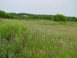
Property Detail
Old River Rd
Rockford, IL
BEG SE COR LT 45 OLD RIVER HILLS NO 1NE 148.12 FT NE 89.9 FT NW 245.5 FT NE132.29 FT E 520.85 FT TO W LN OLD RIVER RD S 258.32 FT W 253 FT S 99 FT E 2
03-25-428-008
WINNEBAGO
Vacantlandnec
Illinois
B and X Area of moderate flood hazard, usually the area between the limits of the 100-year and 500-year floods.
45
2025
6 AC
2025
I-39 Corr/Winnebago Cnty
004002
Chicago
NEARBY LISTINGS FOR SALE OR LEASE
DEMOGRAPHICS near Old River Rd
1 mile
3 mile
5 mile
2025 Total Population
1,783
20,886
51,238
2030 Population
1,744
20,893
51,472
Pop Growth 2025-2030
(2.19%)
+ 0.03%
+ 0.46%
Average Age
43
40
40
2025 Total Households
681
7,904
19,501
HH Growth 2025-2030
(2.20%)
+ 0.04%
+ 0.49%
Median Household Inc
$120,882
$92,973
$84,126
Avg Household Size
2.60
2.60
2.60
2025 Avg HH Vehicles
3.00
2.00
2.00
Median Home Value
$257,481
$214,181
$203,056
Median Year Built
1995
1993
1988
Nearby Places
Map Layers
Map Styles
 Street
 Aerial
Layers
 Traffic
 Biking
Places
Listings with unknown addresses are not visible on the map
- Restaurants
- Banks
- Shops
- Fitness
- Groceries
PUBLIC TRANSPORTATION
AIRPORT
Chicago/Rockford International
Drive
Walk
Distance
Chicago/Rockford International
42 min
20.8 mi
Freight Ports
Port Milwaukee
Drive
Walk
Distance
Port Milwaukee
101 min
81.0 mi
Nearby Properties
Address
Land Use
TOTAL SIZE
Lot Size
Zoning
Address
Land Use
TOTAL SIZE
Lot Size
Zoning
33.53 AC
Address
Land Use
TOTAL SIZE
Lot Size
Zoning
8 AC
CN - COMM
Address
Land Use
TOTAL SIZE
Lot Size
Zoning
Address
Land Use
TOTAL SIZE
Lot Size
Zoning
82,123 SF
1 AC
Address
Land Use
TOTAL SIZE
Lot Size
Zoning
218,074 SF
39.93 AC
IG GENERAL
Address
Land Use
TOTAL SIZE
Lot Size
Zoning
301,509 SF
10.27 AC
IG GENERAL
Address
Land Use
TOTAL SIZE
Lot Size
Zoning
21.80 AC
Address
Land Use
TOTAL SIZE
Lot Size
Zoning
Address
Land Use
TOTAL SIZE
Lot Size
Zoning
2.22 AC
Address
Land Use
TOTAL SIZE
Lot Size
Zoning
Address
Land Use
TOTAL SIZE
Lot Size
Zoning
7.70 AC
IL LIGHT I
Address
Land Use
TOTAL SIZE
Lot Size
Zoning
29,795 SF
1 AC
Address
Land Use
TOTAL SIZE
Lot Size
Zoning
Address
Land Use
TOTAL SIZE
Lot Size
Zoning
2.98 AC
Address
Land Use
TOTAL SIZE
Lot Size
Zoning
64,527 SF
4.25 AC
IL
Address
Land Use
TOTAL SIZE
Lot Size
Zoning
294,355 SF
53.53 AC
IG GENERAL
Address
Land Use
TOTAL SIZE
Lot Size
Zoning
61,500 SF
5.36 AC
IL
Address
Land Use
TOTAL SIZE
Lot Size
Zoning
67,185 SF
4 AC
Address
Land Use
TOTAL SIZE
Lot Size
Zoning
6,112 SF
2.41 AC
CR - COMM
Address
Land Use
TOTAL SIZE
Lot Size
Zoning
11.22 AC
IG
Address
Land Use
TOTAL SIZE
Lot Size
Zoning
49,212 SF
5.99 AC
Address
Land Use
TOTAL SIZE
Lot Size
Zoning
Address
Land Use
TOTAL SIZE
Lot Size
Zoning
7,031 SF
4.60 AC
IL
Address
Land Use
TOTAL SIZE
Lot Size
Zoning
39,445 SF
3.28 AC
CG - COMM
Address
Land Use
TOTAL SIZE
Lot Size
Zoning
6.69 AC
Address
Land Use
TOTAL SIZE
Lot Size
Zoning
15,750 SF
2 AC
Address
Land Use
TOTAL SIZE
Lot Size
Zoning
Address
Land Use
TOTAL SIZE
Lot Size
Zoning
1.99 AC
Address
Land Use
TOTAL SIZE
Lot Size
Zoning
Address
Land Use
TOTAL SIZE
Lot Size
Zoning
1.66 AC
The World's #1 Commercial Real Estate Marketplace
Connect with us
© 2026 CoStar Group
The information above has been obtained from sources believed reliable. While we do not doubt its accuracy we have not verified it and make no guarantee, warranty or representation about it. It is your responsibility to independently confirm its accuracy and completeness. Any projections, opinions, assumptions, or estimates used are for example only and do not represent the current or future performance of the property. The value of this transaction to you depends on tax and other factors which should be evaluated by your tax, financial, and legal advisors. You and your advisors should conduct a careful, independent investigation of the property to determine to your satisfaction the suitability of the property for your needs.