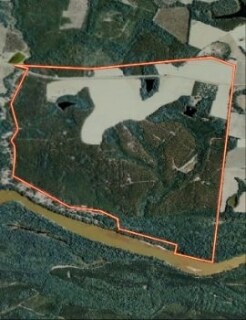
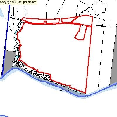
Property Record
Old River Rd, Uvalda, GA 30473

Property Detail
Old River Rd
C08-020
1072.61 AC-OLD RIVER RD
Privatepreserveopenspacevacantlandforestlandconservation
TOOMBS
UNZONED RU
Georgia
A Areas with a 1% annual chance of flooding and a 26% chance of flooding over the life of a 30-year mortgage.
1,072.61 AC
2025
Georgia South Area
2025
Other Market Areas
970600
Vidalia, GA
NEARBY LISTINGS FOR SALE OR LEASE
-
-
View all Uvalda listings for sale on LoopNet.com
DEMOGRAPHICS near Old River Rd
1 mile
3 mile
5 mile
2025 Total Population
211
698
2,179
2030 Population
225
739
2,273
Pop Growth 2025-2030
+ 6.64%
+ 5.87%
+ 4.31%
Average Age
42
42
42
2025 Total Households
86
287
893
HH Growth 2025-2030
+ 5.81%
+ 5.57%
+ 4.14%
Median Household Inc
$73,124
$70,460
$65,984
Avg Household Size
2.30
2.30
2.40
2025 Avg HH Vehicles
2.00
2.00
2.00
Median Home Value
$127,083
$129,605
$132,039
Median Year Built
1991
1992
1992
Nearby Places
Map Layers
Map Styles
 Street
 Aerial
Transit
 Traffic
 Biking
Places
Listings with unknown addresses are not visible on the map
- Restaurants
- Banks
- Shops
- Fitness
- Groceries
Nearby Properties
Address
Land Use
TOTAL SIZE
Lot Size
Zoning
Address
Land Use
TOTAL SIZE
Lot Size
Zoning
2,297.86 AC
Address
Land Use
TOTAL SIZE
Lot Size
Zoning
489.22 AC
UNZONED RU
Address
Land Use
TOTAL SIZE
Lot Size
Zoning
5,124 SF
2.55 AC
UNZONED RU
Address
Land Use
TOTAL SIZE
Lot Size
Zoning
5,560 SF
0.94 AC
COMMERCIAL
Address
Land Use
TOTAL SIZE
Lot Size
Zoning
282.40 AC
UNZONED RU
Address
Land Use
TOTAL SIZE
Lot Size
Zoning
236 AC
UNZONED RU
Address
Land Use
TOTAL SIZE
Lot Size
Zoning
788 AC
RURAL
Address
Land Use
TOTAL SIZE
Lot Size
Zoning
213.34 AC
RESIDENTIA
Address
Land Use
TOTAL SIZE
Lot Size
Zoning
206 AC
UNZONED RU
Address
Land Use
TOTAL SIZE
Lot Size
Zoning
203 AC
UNZONED RU
Address
Land Use
TOTAL SIZE
Lot Size
Zoning
167.98 AC
UNZONED RU
Address
Land Use
TOTAL SIZE
Lot Size
Zoning
205 AC
RESIDENTIA
Address
Land Use
TOTAL SIZE
Lot Size
Zoning
226.51 AC
UNZONED RU
Address
Land Use
TOTAL SIZE
Lot Size
Zoning
144.54 AC
UNZONED RU
Address
Land Use
TOTAL SIZE
Lot Size
Zoning
122.32 AC
UNZONED RU
Address
Land Use
TOTAL SIZE
Lot Size
Zoning
170 AC
RESIDENTIA
Address
Land Use
TOTAL SIZE
Lot Size
Zoning
1,880 SF
139.91 AC
UNZONED RU
Address
Land Use
TOTAL SIZE
Lot Size
Zoning
131 AC
UNZONED RU
Address
Land Use
TOTAL SIZE
Lot Size
Zoning
117 AC
UNZONED RU
Address
Land Use
TOTAL SIZE
Lot Size
Zoning
135.13 AC
UNZONED RU
Address
Land Use
TOTAL SIZE
Lot Size
Zoning
122.97 AC
UNZONED RU
Address
Land Use
TOTAL SIZE
Lot Size
Zoning
92.70 AC
RESIDENTIA
Address
Land Use
TOTAL SIZE
Lot Size
Zoning
89.30 AC
UNZONED RU
Address
Land Use
TOTAL SIZE
Lot Size
Zoning
100.23 AC
UNZONED RU
Address
Land Use
TOTAL SIZE
Lot Size
Zoning
90.72 AC
UNZONED RU
Address
Land Use
TOTAL SIZE
Lot Size
Zoning
85.90 AC
UNZONED RU
Address
Land Use
TOTAL SIZE
Lot Size
Zoning
85.46 AC
UNZONED RU
Address
Land Use
TOTAL SIZE
Lot Size
Zoning
72.94 AC
UNZONED RU
Address
Land Use
TOTAL SIZE
Lot Size
Zoning
118.14 AC
UNZONED RU
The World's #1 Commercial Real Estate Marketplace
Connect with us
© 2026 CoStar Group
The information above has been obtained from sources believed reliable. While we do not doubt its accuracy we have not verified it and make no guarantee, warranty or representation about it. It is your responsibility to independently confirm its accuracy and completeness. Any projections, opinions, assumptions, or estimates used are for example only and do not represent the current or future performance of the property. The value of this transaction to you depends on tax and other factors which should be evaluated by your tax, financial, and legal advisors. You and your advisors should conduct a careful, independent investigation of the property to determine to your satisfaction the suitability of the property for your needs.