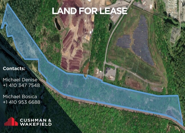
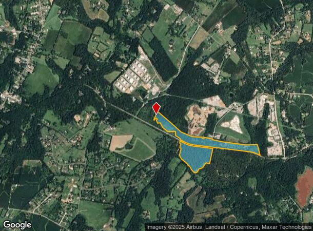
Property Record
Old Washington Rd, , MD
Property Detail
Old Washington Rd
14-009787
82.30 ACS OLD WASHINGTON RD ARTICLES OF MERGER
Industrialgeneral
Carroll
AE
Maryland
24013C0382D
82.30 AC
2025
Carroll County
2025
Baltimore
5142012057
Baltimore-Columbia-Towson, MD
3,740 SF
NEARBY LISTINGS FOR SALE OR LEASE
DEMOGRAPHICS near Old Washington Rd
1 mile
3 mile
5 mile
2024 Total Population
387
10,036
30,490
2029 Population
396
10,287
31,356
Pop Growth 2024-2029
+ 2.33%
+ 2.50%
+ 2.84%
Average Age
43
42
42
2024 Total Households
136
3,434
10,521
HH Growth 2024-2029
+ 2.94%
+ 2.50%
+ 2.88%
Median Household Inc
$130,000
$140,025
$142,152
Avg Household Size
2.80
2.90
2.80
2024 Avg HH Vehicles
3.00
3.00
3.00
Median Home Value
$591,270
$565,941
$557,179
Median Year Built
1980
1983
1985
Nearby Places
Map Layers
Map Styles
 Street
 Aerial
Transit
 Traffic
 Biking
Places
Listings with unknown addresses are not visible on the map
- Restaurants
- Banks
- Shops
- Fitness
- Groceries
PUBLIC TRANSPORTATION
AIRPORT
Baltimore/Washington International Thurgood Marshall
Drive
Walk
Distance
Baltimore/Washington International Thurgood Marshall
47 min
30.4 mi
Freight Ports
Port of Baltimore
Drive
Walk
Distance
Port of Baltimore
48 min
31.0 mi
SALE & LEASE HISTORY
LISTING DATE
SALE/LEASE

Jan 17, 2024
For Lease
Nearby Properties
Address
Land Use
TOTAL SIZE
Lot Size
Zoning
Address
Land Use
TOTAL SIZE
Lot Size
Zoning
9,130 SF
8.23 AC
RCDEO
Address
Land Use
TOTAL SIZE
Lot Size
Zoning
39.15 AC
I-2
Address
Land Use
TOTAL SIZE
Lot Size
Zoning
53.81 AC
I-2
Address
Land Use
TOTAL SIZE
Lot Size
Zoning
27,040 SF
11.58 AC
I-2
Address
Land Use
TOTAL SIZE
Lot Size
Zoning
25,333 SF
9.25 AC
RCDEO
Address
Land Use
TOTAL SIZE
Lot Size
Zoning
25,333 SF
14.29 AC
RCDEO
Address
Land Use
TOTAL SIZE
Lot Size
Zoning
10,560 SF
21.41 AC
R-100
Address
Land Use
TOTAL SIZE
Lot Size
Zoning
10,832 SF
4.99 AC
RCDEO
Address
Land Use
TOTAL SIZE
Lot Size
Zoning
32,730 SF
11.81 AC
B2RCD
Address
Land Use
TOTAL SIZE
Lot Size
Zoning
30,367 SF
14.19 AC
B2RCD
Address
Land Use
TOTAL SIZE
Lot Size
Zoning
9,384 SF
9 AC
RCDEO
Address
Land Use
TOTAL SIZE
Lot Size
Zoning
1,800 SF
66.61 AC
AGRIC
Address
Land Use
TOTAL SIZE
Lot Size
Zoning
14,698 SF
20.84 AC
AGRIC
Address
Land Use
TOTAL SIZE
Lot Size
Zoning
14,272 SF
56.78 AC
AGRIC
Address
Land Use
TOTAL SIZE
Lot Size
Zoning
9,060 SF
18.69 AC
RCDEO
Address
Land Use
TOTAL SIZE
Lot Size
Zoning
6,545 SF
5.17 AC
RCDEO
Address
Land Use
TOTAL SIZE
Lot Size
Zoning
6,923 SF
38.25 AC
RCDEO
Address
Land Use
TOTAL SIZE
Lot Size
Zoning
4,377 SF
58 AC
RCDEO
Address
Land Use
TOTAL SIZE
Lot Size
Zoning
4,056 SF
17.16 AC
AGRIC
Address
Land Use
TOTAL SIZE
Lot Size
Zoning
5,112 SF
4.12 AC
RCDEO
Address
Land Use
TOTAL SIZE
Lot Size
Zoning
640 SF
34.92 AC
I-2
Address
Land Use
TOTAL SIZE
Lot Size
Zoning
8,514 SF
26.57 AC
RCDEO
Address
Land Use
TOTAL SIZE
Lot Size
Zoning
1,615 SF
4.93 AC
I-2
Address
Land Use
TOTAL SIZE
Lot Size
Zoning
3,484 SF
110.95 AC
CONSE
Address
Land Use
TOTAL SIZE
Lot Size
Zoning
2,946 SF
84.30 AC
RCDEO
Address
Land Use
TOTAL SIZE
Lot Size
Zoning
4,900 SF
7.59 AC
I-2
Address
Land Use
TOTAL SIZE
Lot Size
Zoning
4,800 SF
1.71 AC
I-2
Address
Land Use
TOTAL SIZE
Lot Size
Zoning
10,200 SF
9 AC
I-2
Address
Land Use
TOTAL SIZE
Lot Size
Zoning
2,520 SF
3.19 AC
I-2
Address
Land Use
TOTAL SIZE
Lot Size
Zoning
7,682 SF
13.81 AC
RCDEO
The World's #1 Commercial Real Estate Marketplace
Connect with us
© 2026 CoStar Group
The information above has been obtained from sources believed reliable. While we do not doubt its accuracy we have not verified it and make no guarantee, warranty or representation about it. It is your responsibility to independently confirm its accuracy and completeness. Any projections, opinions, assumptions, or estimates used are for example only and do not represent the current or future performance of the property. The value of this transaction to you depends on tax and other factors which should be evaluated by your tax, financial, and legal advisors. You and your advisors should conduct a careful, independent investigation of the property to determine to your satisfaction the suitability of the property for your needs.