Property Record
Old Washington Rd, , MD
NEARBY LISTINGS FOR SALE OR LEASE
Property Detail
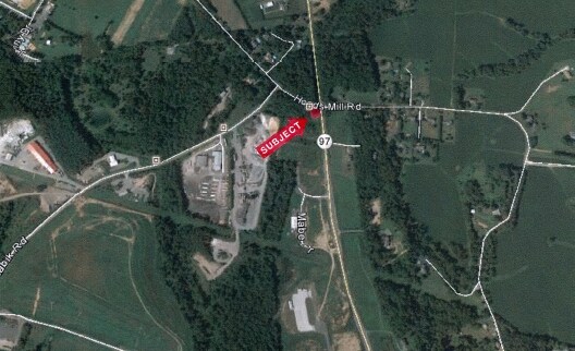
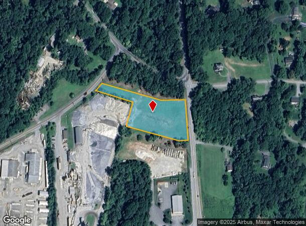
Old Washington Rd
Baltimore-Columbia-Towson, MD
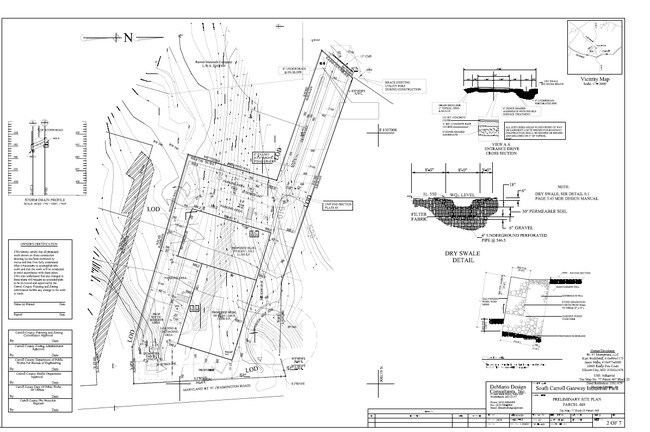
South Carroll Gateway Indl Park
14-053646
LT - 2.0927 ACS W OF MD RT 97
Industrialgeneral
Carroll
X
Maryland
24013C0382D
2.09 AC
2025
Carroll County
2025
Baltimore
5142022014
DEMOGRAPHICS near Old Washington Rd
1 mile
3 mile
5 mile
2024 Total Population
360
13,158
37,171
2029 Population
367
13,591
38,248
Pop Growth 2024-2029
+ 1.94%
+ 3.29%
+ 2.90%
Average Age
43
42
41
2024 Total Households
135
4,721
12,754
HH Growth 2024-2029
+ 1.48%
+ 3.30%
+ 2.96%
Median Household Inc
$112,500
$121,519
$140,321
Avg Household Size
2.70
2.70
2.80
2024 Avg HH Vehicles
3.00
2.00
2.00
Median Home Value
$467,741
$488,732
$487,039
Median Year Built
1977
1984
1986
Nearby Places
Map Layers
Map Styles
 Street
 Aerial
Transit
 Traffic
 Biking
Places
Listings with unknown addresses are not visible on the map
- Restaurants
- Banks
- Shops
- Fitness
- Groceries
PUBLIC TRANSPORTATION
AIRPORT
Baltimore/Washington International Thurgood Marshall
Drive
Walk
Distance
Baltimore/Washington International Thurgood Marshall
40 min
29.3 mi
Freight Ports
Port of Baltimore
Drive
Walk
Distance
Port of Baltimore
40 min
29.0 mi
SALE & LEASE HISTORY
LISTING DATE
SALE/LEASE

Sep 26, 2016
For Lease
Sep 24, 2016
For Sale
Nearby Properties
Address
Land Use
TOTAL SIZE
Lot Size
Zoning
Address
Land Use
TOTAL SIZE
Lot Size
Zoning
46,582 SF
40.96 AC
R-100
Address
Land Use
TOTAL SIZE
Lot Size
Zoning
12,261 SF
8.22 AC
R-750
Address
Land Use
TOTAL SIZE
Lot Size
Zoning
54,981 SF
5.05 AC
R-100
Address
Land Use
TOTAL SIZE
Lot Size
Zoning
72,054 SF
13.95 AC
R-100
Address
Land Use
TOTAL SIZE
Lot Size
Zoning
39.15 AC
I-2
Address
Land Use
TOTAL SIZE
Lot Size
Zoning
59,705 SF
6.21 AC
R-100
Address
Land Use
TOTAL SIZE
Lot Size
Zoning
53.81 AC
I-2
Address
Land Use
TOTAL SIZE
Lot Size
Zoning
27,040 SF
11.58 AC
I-2
Address
Land Use
TOTAL SIZE
Lot Size
Zoning
10,560 SF
21.41 AC
R-100
Address
Land Use
TOTAL SIZE
Lot Size
Zoning
4,146 SF
1 AC
R-100
Address
Land Use
TOTAL SIZE
Lot Size
Zoning
32,730 SF
11.81 AC
B2RCD
Address
Land Use
TOTAL SIZE
Lot Size
Zoning
24,276 SF
3.18 AC
R-750
Address
Land Use
TOTAL SIZE
Lot Size
Zoning
30,367 SF
14.19 AC
B2RCD
Address
Land Use
TOTAL SIZE
Lot Size
Zoning
11,322 SF
61.47 AC
RCDEO
Address
Land Use
TOTAL SIZE
Lot Size
Zoning
1,800 SF
66.61 AC
AGRIC
Address
Land Use
TOTAL SIZE
Lot Size
Zoning
9,013 SF
49.10 AC
RCDEO
Address
Land Use
TOTAL SIZE
Lot Size
Zoning
46,573 SF
1.42 AC
R-100
Address
Land Use
TOTAL SIZE
Lot Size
Zoning
14,698 SF
20.84 AC
AGRIC
Address
Land Use
TOTAL SIZE
Lot Size
Zoning
17,317 SF
0.34 AC
LOCAL
Address
Land Use
TOTAL SIZE
Lot Size
Zoning
4,465 SF
95.67 AC
CONSE
Address
Land Use
TOTAL SIZE
Lot Size
Zoning
12,500 SF
1.74 AC
RCDEO
Address
Land Use
TOTAL SIZE
Lot Size
Zoning
9,060 SF
18.69 AC
RCDEO
Address
Land Use
TOTAL SIZE
Lot Size
Zoning
51,577 SF
3.85 AC
R-750
Address
Land Use
TOTAL SIZE
Lot Size
Zoning
6,960 SF
2.05 AC
R-100
Address
Land Use
TOTAL SIZE
Lot Size
Zoning
6,923 SF
38.25 AC
RCDEO
Address
Land Use
TOTAL SIZE
Lot Size
Zoning
4,377 SF
58 AC
RCDEO
Address
Land Use
TOTAL SIZE
Lot Size
Zoning
4,056 SF
17.16 AC
AGRIC
Address
Land Use
TOTAL SIZE
Lot Size
Zoning
6,857 SF
3.60 AC
RCDEO
Address
Land Use
TOTAL SIZE
Lot Size
Zoning
640 SF
34.92 AC
I-2
Address
Land Use
TOTAL SIZE
Lot Size
Zoning
8,514 SF
26.57 AC
RCDEO
The World's #1 Commercial Real Estate Marketplace
Connect with us
© 2026 CoStar Group
The information above has been obtained from sources believed reliable. While we do not doubt its accuracy we have not verified it and make no guarantee, warranty or representation about it. It is your responsibility to independently confirm its accuracy and completeness. Any projections, opinions, assumptions, or estimates used are for example only and do not represent the current or future performance of the property. The value of this transaction to you depends on tax and other factors which should be evaluated by your tax, financial, and legal advisors. You and your advisors should conduct a careful, independent investigation of the property to determine to your satisfaction the suitability of the property for your needs.