Property Record
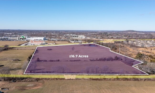
Old Wire Rd, Springdale, AR 72764


Property Detail
Old Wire Rd
Fayetteville-Springdale-Rogers, AR
PT FRL NW 14.724 AC FURTHER DESCRIBED PER 2019-24768 AS: TRACT 2: A PART OF THE FRACTIONAL NORTHWEST QUARTER (FRL NW1/4) OF S
815-28678-001
WASHINGTON
Industrialacreage
Arkansas
A Areas with a 1% annual chance of flooding and a 26% chance of flooding over the life of a 30-year mortgage.
14.72 AC
2025
Greater Springdale
2025
Fayetteville/Springdale/Rogers
010307
NEARBY LISTINGS FOR SALE OR LEASE
DEMOGRAPHICS near Old Wire Rd
1 mile
3 mile
5 mile
2025 Total Population
7,318
52,786
100,807
2030 Population
7,920
56,679
108,387
Pop Growth 2025-2030
+ 8.23%
+ 7.38%
+ 7.52%
Average Age
32
34
35
2025 Total Households
2,059
15,643
32,342
HH Growth 2025-2030
+ 8.55%
+ 7.52%
+ 7.73%
Median Household Inc
$58,134
$61,595
$69,300
Avg Household Size
3.40
3.20
3.00
2025 Avg HH Vehicles
2.00
2.00
2.00
Median Home Value
$236,242
$244,779
$274,623
Median Year Built
1998
1992
1994
Nearby Places
Map Layers
Map Styles
 Street
 Aerial
Transit
 Traffic
 Biking
Places
Listings with unknown addresses are not visible on the map
- Restaurants
- Banks
- Shops
- Fitness
- Groceries
PUBLIC TRANSPORTATION
AIRPORT
Northwest Arkansas Ntl
Drive
Walk
Distance
Northwest Arkansas Ntl
33 min
16.7 mi
Freight Ports
Tulsa Port of Inola
Drive
Walk
Distance
Tulsa Port of Inola
108 min
90.2 mi
SALE & LEASE HISTORY
LISTING DATE
SALE/LEASE

Mar 03, 2023
For Sale
Nearby Properties
Address
Land Use
TOTAL SIZE
Lot Size
Zoning
Address
Land Use
TOTAL SIZE
Lot Size
Zoning
58,764 SF
1.56 AC
Address
Land Use
TOTAL SIZE
Lot Size
Zoning
403,089 SF
1.93 AC
Address
Land Use
TOTAL SIZE
Lot Size
Zoning
153,718 SF
Address
Land Use
TOTAL SIZE
Lot Size
Zoning
341,266 SF
17.61 AC
Address
Land Use
TOTAL SIZE
Lot Size
Zoning
132,494 SF
21.56 AC
Address
Land Use
TOTAL SIZE
Lot Size
Zoning
191,100 SF
10.03 AC
Address
Land Use
TOTAL SIZE
Lot Size
Zoning
292,470 SF
17.27 AC
Address
Land Use
TOTAL SIZE
Lot Size
Zoning
174,333 SF
25 AC
I1I2
Address
Land Use
TOTAL SIZE
Lot Size
Zoning
16,698 SF
1.11 AC
Address
Land Use
TOTAL SIZE
Lot Size
Zoning
178,140 SF
4.39 AC
Address
Land Use
TOTAL SIZE
Lot Size
Zoning
348,916 SF
24.69 AC
Address
Land Use
TOTAL SIZE
Lot Size
Zoning
117,196 SF
9.74 AC
Address
Land Use
TOTAL SIZE
Lot Size
Zoning
224,408 SF
9.80 AC
I1
Address
Land Use
TOTAL SIZE
Lot Size
Zoning
206,446 SF
17.14 AC
Address
Land Use
TOTAL SIZE
Lot Size
Zoning
182,415 SF
68.93 AC
Address
Land Use
TOTAL SIZE
Lot Size
Zoning
182,415 SF
12.04 AC
Address
Land Use
TOTAL SIZE
Lot Size
Zoning
80,475 SF
0.45 AC
C3
Address
Land Use
TOTAL SIZE
Lot Size
Zoning
73,711 SF
3.59 AC
Address
Land Use
TOTAL SIZE
Lot Size
Zoning
147,762 SF
Address
Land Use
TOTAL SIZE
Lot Size
Zoning
352,195 SF
15 AC
Address
Land Use
TOTAL SIZE
Lot Size
Zoning
54,460 SF
6.38 AC
Address
Land Use
TOTAL SIZE
Lot Size
Zoning
153,968 SF
21 AC
Address
Land Use
TOTAL SIZE
Lot Size
Zoning
364,696 SF
4.49 AC
Address
Land Use
TOTAL SIZE
Lot Size
Zoning
189,244 SF
11.16 AC
I2
Address
Land Use
TOTAL SIZE
Lot Size
Zoning
55,663 SF
2.54 AC
Address
Land Use
TOTAL SIZE
Lot Size
Zoning
162,000 SF
16 AC
I2
Address
Land Use
TOTAL SIZE
Lot Size
Zoning
81,121 SF
10.99 AC
Address
Land Use
TOTAL SIZE
Lot Size
Zoning
38,058 SF
9.13 AC
Address
Land Use
TOTAL SIZE
Lot Size
Zoning
62,351 SF
4.75 AC
I2
Address
Land Use
TOTAL SIZE
Lot Size
Zoning
83,998 SF
3.58 AC
C2
The World's #1 Commercial Real Estate Marketplace
Connect with us
© 2026 CoStar Group
The information above has been obtained from sources believed reliable. While we do not doubt its accuracy we have not verified it and make no guarantee, warranty or representation about it. It is your responsibility to independently confirm its accuracy and completeness. Any projections, opinions, assumptions, or estimates used are for example only and do not represent the current or future performance of the property. The value of this transaction to you depends on tax and other factors which should be evaluated by your tax, financial, and legal advisors. You and your advisors should conduct a careful, independent investigation of the property to determine to your satisfaction the suitability of the property for your needs.